Pineville in Bell County, Kentucky — The American South (East South Central)
Bell County War Dead Memorial
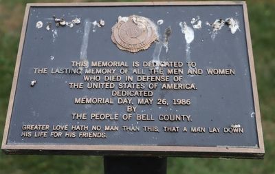
Photographed by Dave W, June 25, 2022
1. Bell County War Dead Memorial Marker
the lasting memory of all the men and women
who died in defense of
the United States of America.
dedicated Memorial Day, May 26, 1986
by the people of Bell County.
Greater love hath no man than this, that a man lay down
his life for his friends.
Erected 1986 by American Legion Bell County.
Topics. This memorial is listed in this topic list: Military.
Location. 36° 45.676′ N, 83° 41.737′ W. Memorial is in Pineville, Kentucky, in Bell County. It is on Kentucky Avenue. Touch for map. Memorial is at or near this postal address: 104 Kentucky Ave, Pineville KY 40977, United States of America. Touch for directions.

Regionally, this memorial is in Eastern Kentucky and in the Cumberland Plateau. It is also in the American South, specifically in the Upper South, in Appalachia, and specifically in Southern Appalachia. Globally, it is in North America, the Western Hemisphere, the Western World, and the Anglosphere. Historically, it finds itself in what was once the territory of the Mississippian Culture and also the Antebellum South.
this page online
Other nearby markers. At least 8 other markers are within 2 miles of this marker, measured as the crow flies: Mountain Gateway (here, next to this marker); Joshua Fry Bell (here, next to this marker); Daniel Boone's Trail (within shouting distance of this marker); Cumberland Ford (approx. 0.2 miles away); The Wilderness Road (approx. 0.4 miles away); Chained Rock (approx. 0.6 miles away); Wallsend Mine (approx. 0.6 miles away); Wilderness Road Cemetery (approx. 1.2 miles away). Touch for a list and map of all markers in Pineville.
Credits. This page was last revised on January 31, 2023. It was originally submitted on January 27, 2023, by Dave W of Co, Colorado. This page has been viewed 282 times since then and 27 times this year. Photo 1. submitted on January 27, 2023, by Dave W of Co, Colorado. • Bill Pfingsten was the editor who published this page.
