Vergennes Township in Lowell in Kent County, Michigan — The American Midwest (Great Lakes)
Island Park
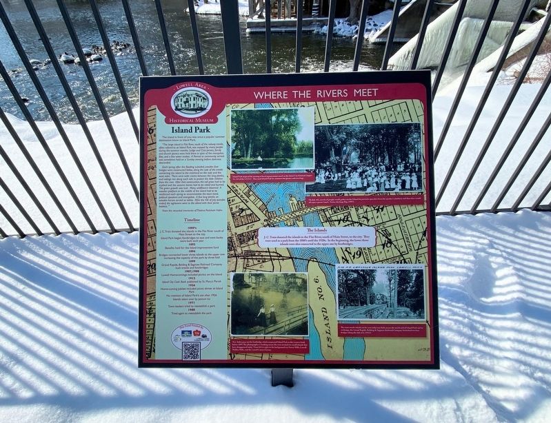
Where The Rivers Meet
"The large island in Flat River, south of the railway trestle, often refered to as Island Park, was enjoyed by many people during the summer months. Lodge and Club picnics, family and church picnics were held there in spite of the mosquitos, flies, and a few water snakes. A Revival or community service was sometimes held on a Sunday evening before darkness descended.
Each spring after the flooding subsided, wooden foot bridges were constructed below, along the side of the trestle connecting the island to the mainland on the east and the west sides. There were wide cracks between the long planks, and railings ran along each side to protect the little children from the river. After that construction, the tall grass had to be scythed and the autumn leaves had to be raked and burned. The green growth was lush. Many wildflowers bloomed. A wooden platform in the middle of the island had to be reinforced each spring to accommodate the town band, political speakers and evangelists. A few long planks on wooden horses served as tables. After the 4th of July parades ended, the sightseers went to the island with their picnic baskets."
-From the recorded memories of Thelma Peckham Hahn
Timeline
1880's
J. C. Train donated the islands in the Flat River south of Main Street to the city. Island Park began; footbridges to east and west banks were built each year
1892
Benefits held for the Island improvement fund
1894
Bridges connected lower three islands to the upper one increasing the capacity of the park by three fold
1899
Grand Rapids, Belding & Saginaw Railroad Company built trestle and footbridges
1907, 1908
Lowell Homecomings included picnics on the Island
1912
Island City Cook Book published by St. Mary's Parish
1926
Home-coming Jubilee included picnic dinner at Island Park No mention of Island Park's use after 1926 Islands taken over by poison ivy
1971
Town leaders tried to reestablish a park
1980
Tried again to reestablish the park
Island Park inspired the naming of local organizations such as the Island City Rebekah Chapter No. 282 of the I.O.O.F. They used Island Park for summertime picnics and meetings. On July 4th, crowds of people would gather on the Island for patriotic speeches from the speaker’s flatform and then they would all enjoy a picnic lunch. Notice the huge flag. (1907)
The Islands
J. C. Train donated the islands in the Flat
River, south of Main Street, to the city. They
were used as a park from the 1880's until the 1920s. In the beginning, the lower three
islands were also connected to the upper one by footbridges.
Two ladies pose on the footbridge which connected Island Park to the western bank before 1899. The photographer is looking across the river toward two small islands that have disappeared today. From left to right in the background are Forest Mills. Lowell Wollen Mills, and the Lowell Cutter Factory.
The train trestle which can be seen today was built across the north end of Island Park and in exchange, the Grand Rapids, Belding & Saginaw Railroad Company furnished two foot bridges along the side of it. (1912)
Erected by Lowell Area Historical Museum.
Topics. This historical marker is listed in this topic list: Parks & Recreational Areas. A significant historical year for this entry is 1892.
Location. 42° 56.054′ N, 85° 20.283′ W. Marker is in Lowell, Michigan, in Kent County. It is in Vergennes Township. Marker is on East Main Street (Michigan Route 21) near South Monroe Street Southeast, on the right when traveling east. Touch for map. Marker is at or near this postal address: 202 East Main Street, Lowell MI 49331, United States of America. Touch for directions.
Other nearby markers. At least 8 other markers are within walking distance of this marker. Clamming and the Button Factory (here, next to this marker); Waterpower
(a few steps from this marker); Lowell Veterans Memorial (within shouting distance of this marker); Lowell Area Veterans Memorial (within shouting distance of this marker); On The Bridge (within shouting distance of this marker); Negonce Block and Bank Block (within shouting distance of this marker); Welcome to Lowell (within shouting distance of this marker); Early Settlers (about 300 feet away, measured in a direct line). Touch for a list and map of all markers in Lowell.
Credits. This page was last revised on February 26, 2023. It was originally submitted on February 21, 2023, by J.T. Lambrou of New Boston, Michigan. This page has been viewed 61 times since then and 21 times this year. Photos: 1, 2, 3. submitted on February 21, 2023, by J.T. Lambrou of New Boston, Michigan. • J. Makali Bruton was the editor who published this page.


