Carlisle in Cumberland County, Pennsylvania — The American Northeast (Mid-Atlantic)
Health Through History
Touring Local Parks and Green Spaces
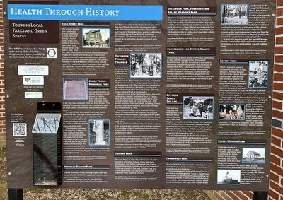
Vale-Himes Park
The ground you are now standing on is the Cumberland County Historical Society's Pocket Park. A one-story building that served as a barber shop existed on this site before 1909. Over the years, the building on this site housed businesses, lodges, and apartments. In 2014, the Cumberland County Historical Society moved to create a pocket park at this 5 North Pitt Street property. The derelict building on the site was torn down in 2015, making space for a small urban park. Landmark lines highlight the significant history of Cumberland County and encourage you to interact with history.
Proceed to N. Pitt Street and turn right. AT the intersection of N. Pitt and W. Penn Street you'll see the entrance to Memorial Park.
James Young Memorial Park
This space began its life as Lincoln Cemetery, an African American burial ground in Carlisle, which was used until 1905. A notable feature is the 1935 train station at West and Penn Streets. This building is currently owned by the Borough and used by Hope Station, a community non-profit formed in 2000.
By 1972, officials determined that a park should replace the site. Borough officials removed the headstones and the park opened in May 194. Renovations throughout the 1990s and 2000s included the addition of the basketball court and spray pool.
The cemetery continues to be a source of interest for local residents and historians who have researched the people buried there, including Civil War veterans who were part of the United States Colored Troops. We now understand the headstones have been lost but the research into this site has opened a new understanding of Carlisle in the late 19th and 20th centuries.
Leaving Memorial Park you're going to turn left and continue down N. Pitt Street. Turn left onto Lincoln Street and right onto Birch Ave. Along Birch you'll find Heberling-Palmer Park.
Heberlig-Palmer Park
The site which now hosts Heberlig-Palmer Park was obtained by the Carlisle Borough and rezoned as park land in the 1960s.
Until 1997, the space was an open field but contributions from the Cumberland County Housing and Redevelopment Authority and the Communities that Care Project allowed for the improvement of the park with soccer goals and benches. The park you see now opened in September 2016, and was redeveloped through the efforts of the Westside Neighbors Association. The Born Learning trail was added in 2017 as an interactive element to support early learning.
Leave Heberlig-Palmer via Lincoln Avenue.
Dickinson College Triangle
Benjamin Rush, a signer of the Declaration of Independence, soldier, and physician to the Philadelphia community, established Dickinson College from a fledgling grammar school on September 9, 1783. This was less than a week after the end of the American Revolution, making it the first college chartered in the United States. (Note the bronze statue of Rush in the triangle.)
Be sure to look at the Old West building, designed by Benjamin Latrobe, architect of the U.S. Capitol. After the New College Building caught fire in 1803, Latrobe created plans for a new college hall. With private donations from individuals, including Thomas Jefferson and James Madison, the College building was reconstructed by 1805.
By 1832, the College was in financial trouble. It closed for a brief period and reopened in 1833 as a Methodist-affiliated college. Looking across the green you'll see the spire to Allison United Methodist church where students attended mandatory chapel services until 1964.
Today Dickinson College hosts over 2,000 students from 40 states and territories and 43 foreign countries. It is a leading academic institution in incorporating sustainability practices into classrooms, campus facilities and culture.
Turn back to Louther Street and head West. You'll pass many of Dickinson College's buildings including Mathers Theater and the Rector Science Complex. Look for 595 W. Louther Street as you walk. This was once the site of Lindner Shoe Company. Known as the Goodyear Building, it was constructed in 1891 by John Lindner and for nearly 30 years the factory produced fine women's shoes until its sale to the Bedford Shoe Company in 1922. The building is now a dormitory for Dickinson College. As the street turns residential you'll see Lindner Park on your right.
Lindner Park
This park began in 1902 due to the Lindner family's interest in cultivating flowers. Along with their greenhouses, they built a public park. One history states every species of tree known to the Cumberland Valley was planted in this park. Lindner Park is a 2-acre shaded park with playground equipment, a basketball court and park benches.
From Lindner continue heading West on Louther Street. At N. Orange Street turn left and at the intersection of Route 11 turn right. You will see the entrance to Dickinson Park on your left.
Dickinson Park, Forbes Path & Valley Meadows Park
Dickinson Park is owned and operated by Dickinson College, but a lease agreement with the Carlisle Borough allows public use of certain facilities. Especially notable is the Carlisle Bicycle and Pedestrian Trail network, which is a 2.1 mile off-road trail linking the Valley Meadows and Forbes Path trails. From start to finish these trails offer 3.1 miles of off-road paths suitable for bicyclists and pedestrians.
Leave Dickinson Park via South Street. When you reach Wilson Street turn right and just past the Medical Arts Building you'll see Partnership for Better Health on your right.
Partnership for Better Health Trail
Partnership for Better Health (PFBH) was established in 2001 with the sale of Carlisle Hospital and Health Services, Inc. The foundation is dedicated to identifying and addressing health care challenges in Cumberland, Perry, Adams and Franklin Counties.
PFBH aims to promote healthy lifestyles and increase accesses to affordable quality health care through community investment, engagement and stewardship. ON the grounds of the building you'll see a community trail that encourages individuals to get moving.
Leaving Partnership for Better Health head down Walnut Street. Turn left onto Moreland Ave and right onto Graham Street. Follow Graham until it becomes Chestnut. You'll see Butcher Tot Lot on your right.
Butcher Family Tot Lot
This park was originally the back garden of the Butcher family. John J. Butcher was a slave from Virginia who settled in Carlisle shortly after the Battle of Gettysburg. Here, he operated a business selling neatsfoot oil and purchased several properties. He left the park property to his ten children and his daughter Alice Butcher, a Carlisle school teacher, sold the property to the borough in 1965.
Local residents from the South of South Street Association (SoSo), Parks and Recreation and the Downtown Carlisle Association revitalized the park in 2013. In December 2013, the park was reopened with new playground equipment.
Leaving the Tot Lot head South towards Walnut Street and turn right. Continue on Walnut Street until you reach S. College Street and turn left. College Street ends at the intersection of Walnut Bottom Road. Across the street you will see Thornwald Park.
Thornwald Park
Thornwald Park is a 32-acre park consisting of open green space, trails, the historic mansion, an amphitheater and pavilions.
Thornwald mansion is privately owned and at one time so were the grounds. Lewis S. Sadler began construction on the mansion in 1909, modeling the house and grounds in the European Palladian style. Construction was completed in 1911 and the Sadler family resided here until 1953 when Horace Sadler sold the estate to the Evangelical Reformed Church for use as a retirement home. 11-acres of the grounds were designated for a new modern retirement home, and in 1972 Carlisle School District purchased the mansion and 32-acres of the original estate. In 1975, Carlisle Borough purchased this property with a preservation grant and a year later the park was dedicated. Additions in the next several years included the amphitheater and jogging trails.
In 2007, the mansion caught fire, possibly because of arson. In 2010, Rkia Hall purchased and restored the mansion as a bed and breakfast, spa and wedding venue.
Leave Thornwald via Walnut Bottom Road and head East towards town. Follow Willow Street until you reach S. Bedford and turn left. When you reach South Street turn right and you will enter Letort Park.
Letort Park
Letort's history is rooted in recreational activities. In 1943, Samuel C. Hertzler donated the land to the Carlisle Kiwanis Club to create a playground and recreation space in the Borough. In the 1960s Letort underwent a beautification and accessibility project, adding lights for the softball field and other improvements. In 1979, the Borough of Carlisle purchased an adjoining 6.1-acres of land to add to the park's recreation space.
In 1993, the park underwent further development with the addition of Fort Letort, a playground designed by the children of Carlisle School district and funded by the community. Today, Letort Park is beloved by children of Carlisle, with many saying it is their most valued place. Letort is also valued for its natural scenery and recreation. It is protected under the Land and Water Conservation Fund Act, ensuring it remains a public park.
Leave Letort Park via E. Pomfret Street and turn right onto N. East Street. When you reach E. North Street turn right and you'll find the entrance to Biddle mission Park on your left.
Biddle Mission Park
Biddle Mission Park is a 5-acre site with .75 miles of walking and biking trail. It used to be the Biddle Mission Presbyterian Parsonage and Church. Within the park you'll find playground equipment, sprinklers, pavilions with picnic tables, a grass volleyball court, basketball court and exercise stations. The Letort Spring Run winds through the western side of the park.
In 2017, residents built a labyrinth in the park as a place for peace and relaxation.
Erected by Cumberland County Historical Society; Greater Carlisle Project; Heart and Soul Initiative with funding from Partnership for Better Health.
Topics and series. This historical marker is listed in these topic lists: Industry & Commerce • Parks & Recreational Areas • Settlements & Settlers. In addition, it is included in the Signers of the Declaration of Independence series list. A significant historical month for this entry is May 1909.
Location. 40° 12.124′ N, 77° 11.471′ W. Marker is in Carlisle, Pennsylvania, in Cumberland County. Marker is on North Pitt Street north of West High Street (U.S. 11), on the right when traveling north. Touch for map. Marker is at or near this postal address: 49 W High St, Carlisle PA 17013, United States of America. Touch for directions.
Other nearby markers. At least 8 other markers are within walking distance of this marker. Vale-Himes Park Landmark Lines (a few steps from this marker); Cumberland County Historical Society & Hamilton Library Association (within shouting distance of this marker); Shell and Be Damned (within shouting distance of this marker); Hot-Chee Dogs (within shouting distance of this marker); Carlisle's 250th Anniversary Mural (within shouting distance of this marker); Prelude to Gettysburg (within shouting distance of this marker); The High Street Train Stations (within shouting distance of this marker); Centenary Building (within shouting distance of this marker). Touch for a list and map of all markers in Carlisle.
Credits. This page was last revised on November 23, 2023. It was originally submitted on March 2, 2023, by Devry Becker Jones of Washington, District of Columbia. This page has been viewed 88 times since then and 23 times this year. Photos: 1, 2. submitted on March 2, 2023, by Devry Becker Jones of Washington, District of Columbia.

