Whitefish Bay in Door County, Wisconsin — The American Midwest (Great Lakes)
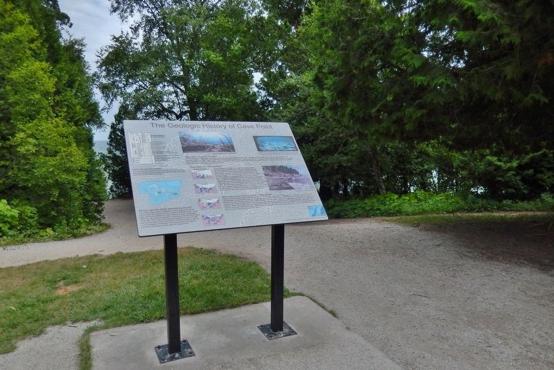
The Geologic History of Cave Point
How old are the rocks?
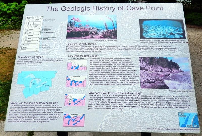
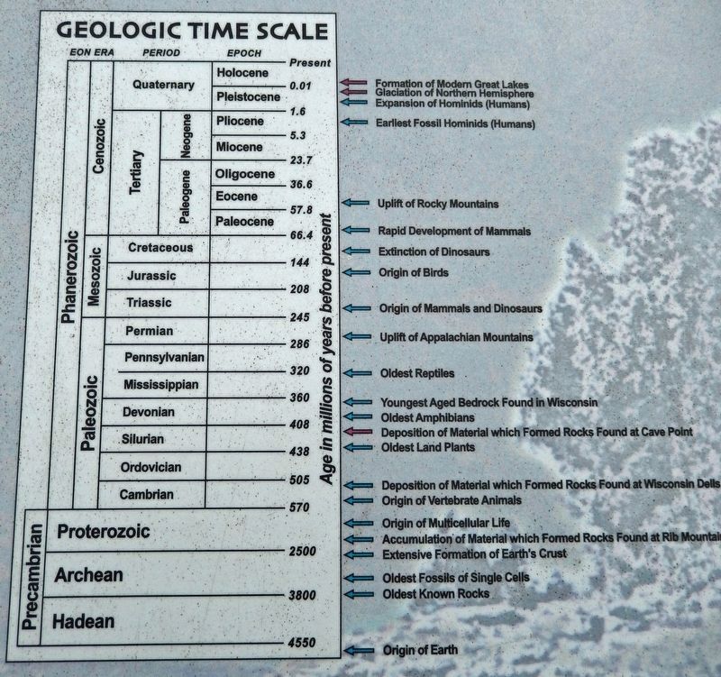
The rocks exposed at Cave Point are from the Silurian Period, a geologic time period which lasted from approximately 435 million years ago to 410 million years ago.
Where can the same bedrock be found?
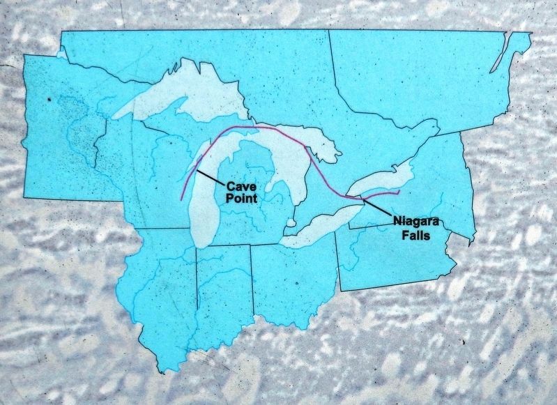
The Silurian aged rocks in Wisconsin and throughout the Great Lakes region are represented by a series of dolomite layers. These layers are more resistant to erosion relative to other similar-aged rocks such as shale and sandstone that may be found in other areas of the state. The rocks in this layer are exposed as a line of bluffs extending throughout the Great Lakes. This line of bluffs is referred to as the Niagara Escarpment. The same series of dolomite is exposed in the Eastern Great Lakes at Niagara Falls.
How were the rocks formed?
During the Silurian Period, the area that is now Cave Point was located near the earth's equator. Coral reefs thrived in what was then a tropical sea. Over the millions of years throughout the Silurian Period, the remains of the marine plants, animals and calcareous sands were deposited and accumulated. These materials and the conditions that existed, followed by millions of years of compaction and chemical alteration, resulted in the formation of dolomite. This is the type of bedrock exposed at Cave Point.
How were the cliffs formed?
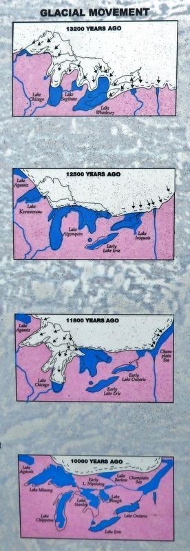
Approximately 410 million years after the Silurian Period, the most recent glaciation of the northern hemisphere took place as massive lobes of continental ice sheets advanced and retreated several times over the Upper Midwest. As the ice covered and uncovered the area, a series of ancient lakes came and went. As a result of scouring by these ice lobes and the drainage system they created, the modern Great Lakes were formed. This glaciation was responsible for much of the erosion that accentuated areas such as Door County and many of the prominent rock outcroppings in the Midwest. As the scouring action of the ice lobes removed the softer rocks and sediments, the more resistant dolomite remained to be attacked by thousands of years of erosion through wave activity. The jagged cliffs and sea caves you see here are examples of those wave-cut features.
Why does Cave Point look like it does today?
There are many forces at work in this geologically active area. The most obvious is not very hard to witness. As you look out into Lake Michigan you can see the waves crashing against the cliffs exposed here at Cave Point. The continuous act of erosion is slowly removing the bedrock where water and land meet. As water enters crevices and other openings in the rocks it collects and freezes in the winter. As the water freezes it expands and enlarges the openings until gravity does its part to remove the large sections. Water also erodes in a less visible but possibly more significant way termed dissolution, the chemical breakdown of the bedrock as a result of its reaction with water. Erosional processes have been changing the way Cave Point looks for millions of years, and will continue to do so in the future.
[photo captions]
• Representation of a Silurian Reef
• Modern reefs such as those seen near the equator are similar to Silurian reefs formed near the equator 425 million years ago.
• Photography courtesy of Harmann’s Studio
Erected by Door County Parks Department; and Door County Soil & Water Conservation Department.
Topics. This historical marker is listed in this topic list: Natural Features.
Location. 44° 55.829′ N, 87° 10.365′ W. Marker is in Whitefish Bay, Wisconsin, in Door County. Marker can be reached from Schauer Road, 0.6 miles east of Clarks Lake Road (County Road WD). Marker is located within Cave Point County Park, beside the Cave Point-Clay Banks State Natural Area parking lot. Touch for map. Marker is at or near this postal address: 5360 Schauer Road, Sturgeon Bay WI 54235, United States of America. Touch for directions.
Other nearby markers. At least 8 other markers are within 4 miles of this marker, measured as the crow flies. Scow Schooner Ocean Wave (approx. half a mile away); Jacksonport United Methodist Church (approx. 3 miles away); St. Michael the Archangel (approx. 3.2 miles away); Anchor & Capstan (approx. 3.3 miles away); Reynolds' Pier (approx. 3.3 miles away); Town of Jacksonport (approx. 3.4 miles away); Erskine Root Cellar (approx. 3.4 miles away); The Episcopal Church of the Holy Nativity (approx. 3.6 miles away).
Also see . . .
1. Cave Point County Park.
Well-known for its wave-worn Dolomite/limestone ledges, underwater caves and stirring view of Lake Michigan, the park is a popular attraction for residents and visitors alike. The land for Cave Point County Park was gifted to the county for preservation by three families in 1943 and 1945: George and Mabel Hanson, Mike and Louise Lyons, and John and Florence Reynolds. It was the fifth park added to the county park system and derived its name from the geological formation. Fun fact: only known County Park to be located within a State Park.(Submitted on March 20, 2023, by Cosmos Mariner of Cape Canaveral, Florida.)
2. Cave Point County Park Geological Features.
Door County is part of a geological formation called the Niagara Escarpment. The escarpment stretches from the state of New York through the Niagara Falls, then through the Bruce Peninsula, across the lower part of Michigan’s Upper Peninsula, shapes the geography of Door County and continues through the east side of Lake Winnebago and the Horicon Marsh, ending in northern Illinois. This feature was formed when glaciers one to two miles thick scraped out soft shale and left harder dolomite exposed, giving shape to the Great Lakes.(Submitted on March 20, 2023, by Cosmos Mariner of Cape Canaveral, Florida.)
Credits. This page was last revised on March 20, 2023. It was originally submitted on March 20, 2023, by Cosmos Mariner of Cape Canaveral, Florida. This page has been viewed 208 times since then and 83 times this year. Photos: 1, 2, 3, 4, 5. submitted on March 20, 2023, by Cosmos Mariner of Cape Canaveral, Florida.
