North Tonawanda in Niagara County, New York — The American Northeast (Mid-Atlantic)
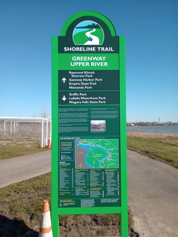
Shoreline Trail
Greenway Upper River
Today's River Road was originally called Military Road as it was constructed by the British Army and joined Fort Erie in Buffalo to Fort Niagara in Lewiston. It was a passage through dense woodland. The road was at most 12 feet wide with clearance of trees and undergrowth extending another 10 feet or so to either side.
The land between the Niagara River for I mile east was known as the "Mile Strip" or the "Niagara Strip". The land belonged to New York State and was reserved from development. In the late 1700's this was part of the land purchased from the state by the Holland Land Company. In the early 1800's their lands were divided into "great lots" by surveyor, Joseph Ellicott. These were sold by the State. The land purchasers were speculators and started to sell subdivisions of their great lots.
In the early 1800's, George Berger constructed a roadhouse about I mile south of here. It was halfway between Buffalo and Lewiston and was used for overnight stays by people traveling between the two towns. As travel increased so did the need for such places and Berger's son-in-law, Joshua Petit, built another roadhouse nearby. Along the Tonawanda Creek, the Van Slyke family operated a third roadhouse.
In 1813, during the War of 1812, all three building were burned by the British in their march of destruction from Fort Niagara to Buffalo.
Several years after the war, people started to settle in the area again. These settlers were farmers. The farms were large and spaced far apart and inland from the river. The entire area was dense forest and going inland gave some protection from the constant winds coming from the river. The farms were self-sustaining for the large families of that time but there was some socialization and trade between the families. Lanes between those farm fields and paths between farms were the beginnings of some of today's city streets.
Later the lumber industry took advantage of these winds to air dry their stacks of lumber before shipping the product off to market.
As the lumber industry here grew, the need for rail transport grew with it. River Road was crossed by numerous sets of railroad spurs. These tracks joined yards of lumber companies that straddled River Road and were joined to the major railroad rights-of-way.
As this area evolved to industry based, some of the original large farms were divided and the land sold for housing lots. A few were sold to other farmers and these combined farms thrived for quite a while, the last being sold in the late 1900's. Among the more notable large family farms are those of the Kohler family and Col. Lewis Payne.
Kohler Family Farm. The house in the background is located at 16 Word Road and is still occupied (as of 2022)!
Topics. This historical marker is listed in these topic lists: Roads & Vehicles • Settlements & Settlers. A significant historical year for this entry is 1813.
Location. 43° 3.038′ N, 78° 53.709′ W. Marker is in North Tonawanda, New York, in Niagara County. Marker is on River Road (New York State Route 265) near Ward Road, on the right when traveling east. Touch for map. Marker is in this post office area: North Tonawanda NY 14120, United States of America. Touch for directions.
Other nearby markers. At least 8 other markers are within walking distance of this marker. Gratwick (a few steps from this marker); The Lumber City (approx. 0.4 miles away); Gratwick Riverside Park (approx. 0.4 miles away); Nikola Tesla (approx. 0.4 miles away); Nikola Tesla Legacy Corridor (approx. 0.4 miles away); Tesla Coil (approx. 0.4 miles away); a different marker also named Lumber City (approx. half a mile away); Edgewater Landing (approx. 0.7 miles away). Touch for a list and map of all markers in North Tonawanda.
Credits. This page was last revised on April 22, 2023. It was originally submitted on April 19, 2023, by Craig Doda of Napoleon, Ohio. This page has been viewed 61 times since then and 14 times this year. Photos: 1, 2. submitted on April 19, 2023, by Craig Doda of Napoleon, Ohio. • Michael Herrick was the editor who published this page.

