Central Waterfront in Camden in Camden County, New Jersey — The American Northeast (Mid-Atlantic)
Aiming the Big Guns
Battleship New Jersey
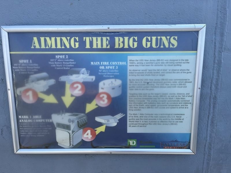
When the USS New Jersey (BB-62) was designed in the late 1930's, aiming a warship's guns was still being carried out the same way it had been for centuries: by visual spotting.
An observer would "spot the fall of shot," or observe where the initial broadside of shells landed, and correct the aim of the guns to bring the next shells fired on target.
By the time the USS New Jersey (BB-62) was commissioned in 1943, the U.S. Navy had developed gunnery radar, which allowed for more accurate shooting. the USS New Jersey's (BB-62) gunfire control system therefore always used both visual and radar data to aim the guns.
Targeting data such as the target's speed, course, distance, and position to the USS New Jersey (BB-62), as well as the "fall of shot" from previous broadsides was fed into the Mark 1 Able Main Battery Computer. This analog computer automatically combined this information with ballistics data such as curvature and rotationa spin of the Earth, wind speed, gunpowder temperature, and the USS New Jersey's (BB-62) own course and speed to arrive at a firing solution.
The Mark 1 Able Computer was a technological masterpiece of its time, and one of the main reasons why U.S. Naval gunfire was the most accurate in the world by the middle of World War II. In fact, it proved so effective that its use was continued throughout the USS New Jersey's (BB-62) 48 years of service!
Erected by Battleship New Jersey.
Topics. This historical marker is listed in these topic lists: War, World II • Waterways & Vessels. A significant historical year for this entry is 1943.
Location. 39° 56.382′ N, 75° 7.992′ W. Marker is in Camden, New Jersey, in Camden County. It is in Central Waterfront. Marker can be reached from Clinton Street west of South Delaware Avenue, on the right when traveling south. The marker is onboard the USS New Jersey. Touch for map. Marker is at or near this postal address: 100 Clinton St, Camden NJ 08103, United States of America. Touch for directions.
Other nearby markers. At least 8 other markers are within walking distance of this marker. Aiming the Secondary Guns (here, next to this marker); Admiral's Flag Bridge (here, next to this marker); Fleet Admiral William Halsey (a few steps from this marker); Teakwood Deck Restoration (a few steps from this marker); 04 Level Navigation Bridge (a few steps from this marker); Close-In Weapons System (a few steps from this marker); a different marker also named Admiral's Flag Bridge (a few steps from this marker); Admirals and the Flag Cabin (a few steps from this marker). Touch for a list and map of all markers in Camden.
Credits. This page was last revised on April 24, 2023. It was originally submitted on April 24, 2023, by Devry Becker Jones of Washington, District of Columbia. This page has been viewed 50 times since then and 9 times this year. Photos: 1, 2. submitted on April 24, 2023, by Devry Becker Jones of Washington, District of Columbia.

