Puerta de Tierra in San Juan in Municipio de San Juan, Puerto Rico — The Caribbean (The West Indies)
Tercera Línea de Defensa: Trincheras
[Third Line of Defense: Trincheras]
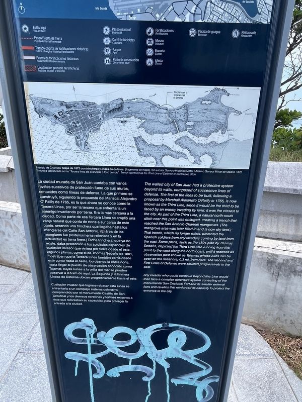
La ciudad murada de San Juan contaba con varios niveles sucesivos de protección fuera de sus muros, conocidos como líneas de defensa. La que primero se construyó, siguiendo la propuesta del Mariscal Alejandro O'Reilley de 1765, es la que ahora se conoce como la Tercera Línea, por ser la tercera que enfrentaría un enemigo invadiendo por tierra. Era la más cercana a la ciudad. Como parte de esa Tercera Línea se amplió una zanja natural que corría de norte a sure cerca de este punto, creando una trinchera que llegaba hasta los manglares fue posteriormente rellenada y en la actualidad es tierra firme.) Dicha trinchera, que ya no existe, daba protección a los soldados españoles de cualquier invasor que viniera por tierra desde el este. Algunos planos, como el de Thomas Sedeño de 1801, mostraban que la Tercera Línea también corría desde este punto hacia al oeste, bordeando la costa norte, hasta llegar al puesto de observación conocido como Tajamar, cuyas ruinas a la orilla del mar se pueden observar a 0.5 km de aquí. La Segunda y la Primera Líneas de Defensa ubican progresivamente hacia el este.
Cualquier invasor que lograse rebasar esta Línea se enfrentaría a un complejo sistema defensivo comprendido por el monumental Castillo de San Cristóbal y los diversos revellines y fortines externos a éste que reforzaban su capacidad para proteger la entrada a la ciudad.
Any invader who could continue beyond this Line would then face a complex defensive system consisting of the monumental San Cristobal Fort and its smaller external forts and ravelins that reinforced its capacity to protect the entrance to the city.
Erected by Paseo Puerto de Tierra.
Topics. This historical marker is listed in these topic lists: Colonial Era • Forts and Castles. A significant historical year for this entry is 1765.
Location. 18° 27.954′ N, 66° 5.697′ W. Marker is in San Juan in Municipio de San Juan, Puerto Rico. It is in Puerta de Tierra. Marker is on Avenida Luis Muñoz Rivera (Puerto Rico Route 25R) west of Calle Llugo Vitías. Touch for map. Marker is at or near this postal address: Avenida Luis Muñoz Rivera 402, San Juan PR 00918, United States of America. Touch for directions.
Other nearby markers. At least 8 other markers are within walking distance of this marker. Segunda línea de defensa (a few steps from this marker); Palma real (approx. 0.2 kilometers away); Emajagüilla (approx. 0.3 kilometers away); Polvorín de San Jerónimo (approx. half a kilometer away); Memorial de Pulse (Pulse Memorial) (approx. 0.6 kilometers away); First Line of Defense (approx. 1.1 kilometers away); Ataques a la Isleta (approx. 1.1 kilometers away); Barack H. Obama (approx. 1.1 kilometers away). Touch for a list and map of all markers in San Juan.
Credits. This page was last revised on June 14, 2023. It was originally submitted on June 14, 2023, by Devry Becker Jones of Washington, District of Columbia. This page has been viewed 47 times since then and 2 times this year. Photos: 1, 2, 3. submitted on June 14, 2023, by Devry Becker Jones of Washington, District of Columbia.


