Near Tuskahoma in Pushmataha County, Oklahoma — The American South (West South Central)
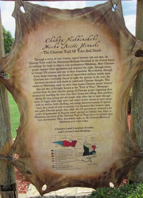
Chahta Nishkinokchi Micha Aiilli Hinushi / The Choctaw Trail of Tears and Death
Inscription.
Through a series of nine treaties, signed between 1786 and 1830, the Choctaw Tribe ceded the Mississippi/Alabama homeland to the United States in exchange for lands in what is now southeastern Oklahoma. Most Choctaw people opposed these agreements and obtained the right, through treaty, to become US citizens and stay in their homeland. Nevertheless, through fraud, home burning, and threats of unprovoked military attack, most Choctaws were eventually forced to make the journey to the west, the direction associated with death in traditional Choctaw thought. This exodus to Oklahoma, made by more than 12,000 Choctaw people between 1830 and 1833, is fittingly known as the "Trail of Tears." Newspaper articles from the time describe groups of Choctaw people beginning their journeys by touching the trees near their homes and telling them goodbye. Along the way, young and old people alike often had to wade through miles of frigid, waist high water and endure winter storms in open camps with no shelter, little clothing, and eating shortened rations of spoiled food. As a result of such treatment, it is estimated that between 1,800 and 4,000 Choctaw people died, while the US government obtained a net profit of $3,000,000 by keeping travel expenses so lethally low. Once in Oklahoma, survivors of the Choctaw Trail of Tears strove to rebuild their lives and families. Their descendants make up the Choctaw Nation of Oklahoma as it exists today.
Choctaw Land Cessation Treaties and Current Land Holdings
Treaty of Fort Adams, 1801, 2,641,920 acres
Treaty of Hoe Backintoopa, 1803, 853,760 acres
Treaty of Mount Dexter, 1805 4,142,720 acres
Treaty of Fort St. Stephens, Disputed acreage
Treaty of Doak's Stand, 1820 5,169,788 acres (Choctaw Cession to U.S.)
Treaty of Doak's Stand, 1820, 13,000,000 Acres (U.S. Cession to Choctaw)
Treaty of 1825 (Re-et Eastern Border of Doak's Stand Lands)
Treaty of Dancing Rabbit Creek, 1830 10,423,130 acres
Treaty of 1866, about 7,000,000 acres
Extent of Choctaw Nation of Oklahoma 2007 (Tiny portion is tribally owned)
2007 Choctaw Reservation Boundaries (Blown up for visibility)
Erected by Oklahoma Historical Society.
Topics. This historical marker is listed in this topic list: Native Americans. A significant historical year for this entry is 1786.
Location. 34° 38.487′ N, 95° 16.68′ W. Marker is near Tuskahoma, Oklahoma, in Pushmataha County. Marker can be reached from North 4355 Road, 1.2 miles north of U.S. 271. The marker is located on the grounds of the Choctaw Nation Capitol Museum along the Choctaw history trail. Touch for map . Marker is at or near this postal address: 163663 N 4355 Rd, Tuskahoma OK 74574, United States of America. Touch for directions.
Other nearby markers. At least 8 other markers are within walking distance of this marker. Miko Pushmataha (within shouting distance of this marker); Chahta Nafohka / Choctaw Clothing (within shouting distance of this marker); Chahta Aiyimmika / Choctaw Religion (within shouting distance of this marker); Chahta Ichukka Chashpo / The Early Choctaw Home (within shouting distance of this marker); Choctaw Nation War On Terrorism Memorial (within shouting distance of this marker); Chahta I Yakni Vlhpisa Ikki / Choctaw Nation of Oklahoma Government (within shouting distance of this marker); Ishtaboli / Game of Stickball (within shouting distance of this marker); Illimpa (Food) (within shouting distance of this marker). Touch for a list and map of all markers in Tuskahoma.
Credits. This page was last revised on June 23, 2023. It was originally submitted on June 23, 2023, by Jason Armstrong of Talihina, Oklahoma. This page has been viewed 68 times since then and 25 times this year. Photo 1. submitted on June 23, 2023, by Jason Armstrong of Talihina, Oklahoma. • J. Makali Bruton was the editor who published this page.
