Currie in Pender County, North Carolina — The American South (South Atlantic)
Stunning Defeat
| — | Moores Creek National Battlefield | — |
Photographed by Dave W, June 17, 2023
1. Stunning Defeat Marker
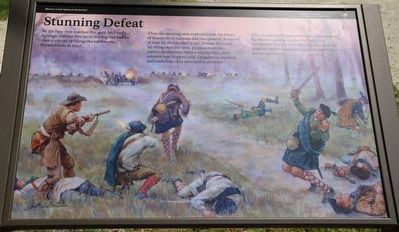
By the time they reached this spot, McLeod's loyalists realized they were in a trap but had no choice except to charge the earthworks, broadswords in hand.
Then the morning mist exploded with the blasts of hundreds of muskets and two cannon. A torrent of lead hit the loyalists, Capt. Donald McLeod lay dying near this spot, 30 paces from the patriot earthworks. After a second blast, their advance was stopped cold. Outgunned, stunned, and leaderless, they retreated in disorder.
This decisive battle had profound consequences for North Carolina and for the American Revolution. For the Scots Highlanders, it would mark the last broadsword charge in their long and proud history.
Erected by National Park Service, U.S. Department of the Interior.
Topics. This historical marker is listed in these topic lists: Patriots & Patriotism • War, US Revolutionary. A significant historical date for this entry is February 27, 1776.
Location. 34° 27.514′ N, 78° 6.774′ W. Marker is in Currie, North Carolina, in Pender County. It can be reached from Patriots Hall Drive north of Moores Creek Drive, on the left when traveling north. Touch for map.
this page online

Regionally, this marker is in the Coastal Plain. It is also in the American South, specifically in the Upper South, in the Tidewater, and on the Eastern Seaboard. Globally, it is in the North Atlantic Region, North America, the Western Hemisphere, the Western World, and the Anglosphere. Historically, it finds itself in what was once the territory of the Mississippian Culture, one of the original Thirteen Colonies, one of the Confederate States of America, and the Antebellum South.
Other nearby markers. At least 8 other markers are within walking distance of this marker: Old Wilmington and Fayetteville Stage Road (within shouting distance of this marker); Decisive Victory (within shouting distance of this marker); Aftermath of Moores Creek (within shouting distance of this marker); Wisely Chosen Ground (about 300 feet away, measured in a direct line); A Very Bad Swamp ... (about 300 feet away); Widow Moores' Bridge (about 400 feet away); John Grady Memorial (about 400 feet away); Commemorating the Battle
Photographed by Dave W, June 17, 2023
2. Stunning Defeat Marker
Also see . . . Moores Creek National Battlefield. National Park Service (Submitted on June 25, 2023.)
Credits. This page was last revised on June 25, 2023. It was originally submitted on June 23, 2023, by Dave W of Co, Colorado. This page has been viewed 187 times since then and 25 times this year. Photos: 1, 2. submitted on June 23, 2023, by Dave W of Co, Colorado. • Bernard Fisher was the editor who published this page.
