Hudson Yards in Manhattan in New York County, New York — The American Northeast (Mid-Atlantic)
Freight Rail on Manhattan's West Side / High Line
Inscription.
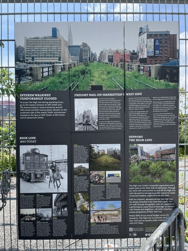
Freight Rail on Manhattan's West Side
The 19th century brought a population boom and rapid growth in manufacturing to New York City. To serve the growing metropolis, freight rail lines were constructed along the city streets and waterfronts. The High Line was built by New York Central Railroad between 1929 and 1934 to eliminate street-level train crossings from 34th Street to Spring Street in an effort to improve both efficiency and public safety.
For years the High Line served as an integral part of Manhattan's industrial landscape—the "Life Line of New York." The elevated railway allowed for efficient deliveries of meat, produce, and dairy products into the warehouses and factories up and down the West Side. Yet the decline of manufacturing in Manhattan, train traffic in the 1950s and 1960s began to decrease on the High Line, and the elevated railway fell into a state of disuse.
In 1999, CSX Transportation, the national rail freight carrier and then-owner of the High Line, commissioned a planning study to assess the reuse of the elevated railway. that study was presented at a Community Board meeting in West Chelsea, inspiring two neighborhood residents, Joshua David and Robert Hammond, to create Friends of the High Line, an organization to advocate for the adaptive re-use of the High Line.
Following years of collaboration with the City of New York and Friends of the High Line, in 2006 CSX donated the High Line to the City of New York, paving the way for the High Line to be opened to the public.
The West Side of Manhattan has been transformed from an industrial district into residential and commercial neighborhoods with new parks and cultural activities. The High Line is a physical reminder of the important role of the railroad in New York City's industrial past.
High Line
1840 - Today
1840s
An Industrial Waterfront
The West Side of Manhattan is the country's busiest industrial waterfront. In 1847, the City of New York authorizes street-level railroad tracks. Trains from Hudson River Railroad, which later becomes the New York Central Railroad, serve the industrial buildings along the West Side.
1851
Death Avenue
Street-level railroad traffic causes so many accidents that the West Side's freight corridor becomes known as "Death Avenue." New York Central Railroad hires men on horseback, called West Side Cowboys, to ride in front of trains, waving pedestrians out of the way.
1929
Building the High Line
After decades of debate, the City and State
of New York and the New York Central Railroad begin the West Side Improvement Project, a massive infrastructure project to eliminate street-level rail corridors. the project transforms the West Side, eliminates 105 street-level railroad crossings, and includes an elevated section of track known as the High Line.
1934
Lifeline of New York
The High Line opens as an active freight rail line, running from West 34th Street to St. John's Park Terminal. Elevated 30 feet above the street, the High Line is designed to connect directly to the upper floor loading docks of factories and warehouses, delivering milk, meat, produce, and other goods. It was known as the "Life Line of New York."
1960s
Decline
Industrial use begins to decline on Manhattan's West Side. The advance of the interstate highway system and the growth of the trucking industry lead to a reduction of rail traffic on the High Line and at other railroads across the United States. In the 1960s, the southernmost nine blocks of the High Line, from Clarkson Street to Bank Street, are demolished. Another five block section from Bank Street to Gansevoort Street is demolished in the 1990s.
1980s
Nature Takes Over
In 1980, the last train rolls down the High Line carrying three carloads of frozen turkeys. For the next two decades, the High Line sits, unused, while nature begins to reclaim it. Sees are carried in by the wind and by birds and insects, and begin to take root in the gravel ballast of the High Line. Over time, an entire self-seeded landscape emerges amid the steel railroad tracks, visible only to the few inhabitants in adjacent buildings.
1999
Friends of the High Line
Two neighborhood residents, Joshua David and Robert Hammond, meet at a community board meeting in West Chelsea, where local leaders are discussing plans to demolish the High Line. The two young New Yorkers from a non-profit group called friends of the High Line to advocate for the High Line's preservation and transformation into public open space.
2002
A Partnership with the City
Michael R. Bloomberg is elected Mayor and reverses previous City policy, which favored demolition, and commits to the preservation and reuse of the High Line. The following year, the city Council, under the leadership of Speaker Gifford Miller and Councilwoman Christine C. Quinn, makes an initial capital commitment to convert the High Line into a public park.
2005
CSX Donates High Line
Following six years of close collaboration with the City of New York and Friends of the High Line, CSX Transportation donates the southern segment of the High Line. The City and CSX execute a Trail Use Agreement for the High Line, under the federal "Rails to Trails" program. Seven years later, CSX donates the High Line at the Rail Yards.
2009 - 2019
High Line Opens
Ten years after Friends of the High Line was first formed to advocate to save and transform the railway, the first section of the High Line, between Gansevoort and 20th Streets, opens in June 2009. The second section, between 20th and 30th Streets, follows suit quickly and opens in June 2011. The third section, between 30th and 34th Streets, opens in September 2014. the Spur, the final section of the original railway and one of the sections once most at danger of demolition, along 30th Street between 10th and 11th Avenues, opens in June 2019.
Today
A More Connected Neighborhood The full length of historic, elevated railway has been transformed into public open space. The High Line now connects three neighborhoods along Manhattan's West Side—the Meatpacking District, Chelsea, and Hudson Yards. Looking ahead, with a new proposal for increased pedestrian connectivity on the West side, you may soon be able to more easily walk from the High Line to Moynihan Train Hall to the east and Hudson River Park to the west.
Erected by NYC Parks.
Topics. This historical marker is listed in these topic lists: Industry & Commerce • Parks & Recreational Areas • Railroads & Streetcars. A significant historical year for this entry is 1929.
Location. 40° 45.382′ N, 74° 0.217′ W. Marker is in Manhattan, New York, in New York County. It is in Hudson Yards. Marker is on West 34th Street east of 12th Avenue (New York State Route 9A), on the right when traveling east. Touch for map. Marker is at or near this postal address: 656 West 34th Street, New York NY 10001, United States of America. Touch for directions.
Other nearby markers. At least 8 other markers are within walking distance of this marker. Speed, Splendor, and Safety: the U.S. United States (approx. 0.2 miles away); Becoming A Park (approx. 0.2 miles away); NYPD Tow Pound (approx. 0.2 miles away); Pier 76 Construction (approx. 0.2 miles away); Bella Abzug Park (approx. 0.2 miles away); Once Water, Now Land (approx. 0.2 miles away); Container Shipping Connecting the World (approx. 0.2 miles away); Hell's Kitchen (approx. 0.2 miles away). Touch for a list and map of all markers in Manhattan.
Credits. This page was last revised on July 20, 2023. It was originally submitted on July 20, 2023, by Devry Becker Jones of Washington, District of Columbia. This page has been viewed 98 times since then and 44 times this year. Photos: 1, 2. submitted on July 20, 2023, by Devry Becker Jones of Washington, District of Columbia.

