Montpelier in Washington County, Vermont — The American Northeast (New England)
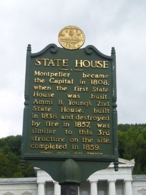
State House
Montpelier became the Capitol in 1808, when the first State House was built. Ammi B. Young's 2nd State House, built in 1838 and destroyed by fire in 1857, was similar to this 3rd structure on the site, completed in 1859.
Erected 1949 by Vermont Historic Sites Commission.
Topics. This historical marker is listed in these topic lists: Government & Politics • Notable Buildings. A significant historical year for this entry is 1808.
Location. 44° 15.689′ N, 72° 34.856′ W. Marker is in Montpelier, Vermont, in Washington County. Marker is on State Street, 0.1 miles east of Bailey Avenue, on the right when traveling west. Touch for map. Marker is at or near this postal address: 115 State Street, Montpelier VT 05602, United States of America. Touch for directions.
Other nearby markers. At least 8 other markers are within walking distance of this marker. Vermont Equality For Same-Sex Couples (about 300 feet away, measured in a direct line); Steel Krupp Gun (about 300 feet away); Lafayette’s Tour / Le Tour De Lafayette (about 300 feet away); Ethan Allen (about 300 feet away); Ammi B. Young (about 400 feet away); Thomas Chittenden (about 400 feet away); Site of the Caldwell House (approx. 0.3 miles away); Flood of 1927, Montpelier and Wells River Railroad Station and Yard (approx. 0.4 miles away). Touch for a list and map of all markers in Montpelier.
Credits. This page was last revised on November 1, 2021. It was originally submitted on September 30, 2009, by Karen Eaton of Westfield, Massachusetts. This page has been viewed 1,369 times since then and 41 times this year. Photos: 1, 2. submitted on September 30, 2009, by Karen Eaton of Westfield, Massachusetts. 3. submitted on November 1, 2021, by Larry Gertner of New York, New York. • Kevin W. was the editor who published this page.


