Saint Victor in Paris in Département de Paris, Île-de-France, France — Western Europe
Enceinte de Philippe Auguste
⎯⎯⎯
The Wall of Philip II Augustus
| — | Histoire de Paris | — |

Photographed by Andrew Ruppenstein, June 26, 2023
1. Enceinte de Philippe Auguste / The Wall of Philip II Augustus Marker

En 1190, avant son départ pour la troisième croisade, Philippe Auguste (1165-1223) demande aux habitants de contribuer à la sécurité de la ville. par la construction d'une muraille d'environ 5 km, achevée vers 1210. Cette courtine, haute de dix mètres et couronnée d'un chemin de ronde crénelé, est percée d'une dizaine de portes. Bornee à l'ouest par la forteresse du Louvre, édifiée pour la protéger dans les premières années du XIIIe siècle, à l'est par la place de Grève, a nord par les Halles, et au sud par le bourg Sainte-Genevieve, elle détinit une capitale de 250 hectares: désormais, le palais, le trésor et les archives s'y trouvent fixés à demeure, même si le roi n'y réside pas toujours. Il s'agit de la première tentative d'union des trois quartiers parisiens : la «Cité», cœur religieux, administratif et judiciaire, la «Ville», pôle économique situé autour des ports de la rive droite, et «l'Université» naissante, rive gauche.
In 1190, before his departure for the third crusade, Philippe Auguste (1165-1223) asked the inhabitants to contribute to the security of
this page online
Topics and series. This historical marker is listed in this topic list: Forts and Castles. In addition, it is included in the Histoire de Paris series list.
Location. 48° 50.756′ N, 2° 21.002′ E. Marker is in Paris, Île-de-France,
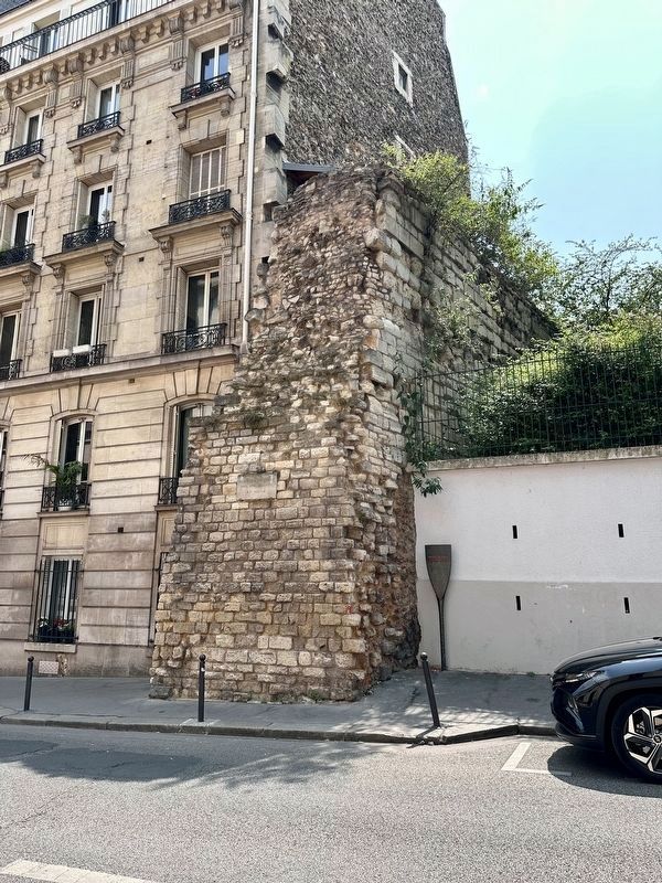
Photographed by Andrew Ruppenstein, June 26, 2023
2. Enceinte de Philippe Auguste / The Wall of Philip II Augustus and Marker

Regionally, it is in the North Atlantic Region, Europe, the European Union, Atlantic Europe, the Schengen Area, Western Europe, a coastal Mediterranean country, and the Western World. Historically, it finds itself in what was once a French colony and also the Roman Empire.
Other nearby markers. At least 8 other markers are within walking distance of this marker: Collège des Ecossais / Scots College (within shouting distance of this marker); Valery Larbaud (1881-1957) (within shouting distance of this marker); James Joyce (1882-1941) (within shouting distance of this marker); Les Quatre Sergents de La Rochelle / The Four Sergeants of La Rochelle (within shouting distance of this marker); Paul de Chomedey (within shouting distance of this marker); René Descartes (about 120 meters away, measured in a direct line); Ernest Hemingway (1899-1961) (about 120 meters away); Ecole Élémentaire Rollin Jewish Students Deportation Memorial

Photographed by Andrew Ruppenstein, June 26, 2023
3. Additional plaque
On the wall itself is an additional plaque identifying it as being the remains of the wall of Philippe Auguste, from the 12th Century.
Also see . . . Wall of Philip II Augustus (Wikipedia).
Excerpt: The Wall of Philip Augustus is the oldest city wall of Paris (France) whose plan is accurately known. Partially integrated into buildings, more traces of it remain than of the later fortifications.(Submitted on July 25, 2023.)
The wall was built during the struggles between Philip II of France (called Philip Augustus) and the Anglo-Norman House of Plantagenet. The French king, before leaving for the Third Crusade, ordered a stone wall to be built to protect the French capital in his absence.
Additional keywords. panneau
Credits. This page was last revised on May 1, 2025. It was originally submitted on July 25, 2023, by Andrew Ruppenstein of Lamorinda, California. This page has been viewed 460 times since then and 96 times this year. Photos: 1, 2, 3. submitted on July 25, 2023, by Andrew Ruppenstein of Lamorinda, California.
