Near Munising in Alger County, Michigan — The American Midwest (Great Lakes)
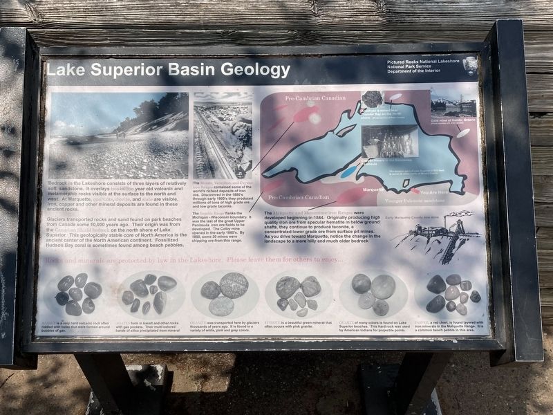
Lake Superior Basin Geology
Bedrock in the Lakeshore consists of three lavers of relativelv soft sandstone. It overlays two-billion year old volcanic and metamorphic rocks visible at the surface to the north and west. At Marquette, quartzite, diorite, and slate are visible. Iron, copper and other mineral deposits are found in these ancient rocks.
Glaciers transported rocks and sand found on park beaches from Canada some 10,000 years ago. Their origin was from the Canadian Shield bedrock on the north shore of Lake Superior. This geologically stable core of North America is the ancient center of the North American continent. Fossilized Hudson Bay coral is sometimes found among beach pebbles.
The Mesabi. Vermilion. and Cuvuna iron Ranges contained some of the world's richest deposits or iror ore. Discovered in the 1880's through early 1900's they produced millions of tons of high grade ore and low grade taconite.
The Gogebic Range flanks the Michigan - Wisconsin boundary. It was the last of the great Upper Peninsula iron ore fields to be develoned The Colby mine opened in the early 1880's. By 1890. some 30 mines were shipping ore from this range.
The Marquette and Menominee iron Ranges were developed beginning in 1844. Originally producing high quality iron ore from specular hematite in below ground shafts, they continue to produce taconite, a concentrated lower grade ore from surface pit mines. As you drive toward Marquette, notice the change in the landscape to a more hilly and much older bedrock.
Rocks and minerals are protected by law in the Lakeshore. Please leave them for others to enjoy...
Basalt is a very hard volcanic rock often riddled with holes that were formed around bubbles of gas.
Agates form in basalt and other rocks with gas pockets Their multi-colored bands of silica precipitated from mineral.
Granite was transported here by glaciers thousands of years ago. It is found in a variety of white, pink and grey colors.
Epidote is a beautiful green mineral that often occurs with pink granite.
Quartz of many colors is found on Lake Superior beaches. This hard rock was used by American Indians for projectile points.
Jasper, a red chert is found layered with iron minerals in the Marquette Range. It is common beach pebble in the area.
Erected by Pictured Rocks National Lakeshore, National Park Service, Department of the Interior.
Topics. This historical marker is listed in this topic list: Environment. A significant historical year for this entry is 1844.
Location. 46° 29.66′ N, 86° 33.048′ W. Marker is near Munising, Michigan, in Alger County. Marker can be reached from Miners Castle Road north of County Route 58. Touch for map. Marker is in this post office area: Munising MI 49862, United States of America. Touch for directions.
Other nearby markers. At least 8 other markers are within 8 miles of this marker, measured as the crow flies. Different Perspectives (within shouting distance of this marker); Grand Island View (about 300 feet away, measured in a direct line); Crumbling Into Time (about 400 feet away); U.S. Coast Guard (approx. 4 miles away); Munising Falls (approx. 6 miles away); Munising Public Dock (approx. 7˝ miles away); Shipwrecks of the Alger Underwater Preserve (approx. 7˝ miles away); Russell A. Alger (approx. 7.8 miles away). Touch for a list and map of all markers in Munising.
Credits. This page was last revised on August 24, 2023. It was originally submitted on August 17, 2023, by Connor Olson of Kewaskum, Wisconsin. This page has been viewed 49 times since then and 10 times this year. Photo 1. submitted on August 17, 2023, by Connor Olson of Kewaskum, Wisconsin. • J. Makali Bruton was the editor who published this page.
Editor’s want-list for this marker. A wide view photo of the marker and the surrounding area together in context. • Can you help?
