Bryant in Saline County, Arkansas — The American South (West South Central)
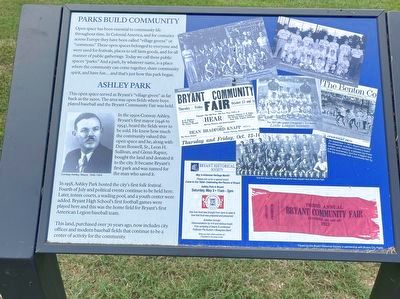
Ashley Park
Parks Build Community
Open space has been essential to community life throughout time. In Colonial America, and for centuries across Europe they have been called "village greens" or "commons." These open spaces belonged to everyone and were used for festivals, places to sell farm goods, and for all manner of public gatherings. Today we call these public spaces "parks." And a park, by whatever name, is a place where the community can come together, share community spirit, and have fun... and that's just how this park began.
Ashley PARK
This open space served as Bryant's "village green" as far back as the 1920s. The area was open fields where boys played baseball and the Bryant Community Fair was held.
In the 1950s Conway Ashley, Bryant's first mayor (1946 to 1954), heard the fields were to be sold. He knew how much the community valued this open space and he, along with i Dean Boswell, Sr., Leon H. Sullivan, and Glenn Rapier, bought the land and donated it to the city. It became Bryant's first park and was named for the man who saved it.
In 1958, Ashley Park hosted the city's first folk festival. Fourth of July and political events continue to be held here. Later, tennis courts, a wading pool, and a youth center were added. Bryant High School's first football games were played here and this was the home field for Bryant's first American Legion baseball team.
This land, purchased over 70 years ago, now includes city offices and modern baseball fields that continue to be a center of activity for the community.
Topics. This historical marker is listed in this topic list: Parks & Recreational Areas.
Location. 34° 35.611′ N, 92° 29.603′ W. Marker is in Bryant, Arkansas, in Saline County. Marker is on Southwest 2nd Street, 0.1 miles north of Short Street, on the left when traveling north. Ashley Park. Touch for map. Marker is in this post office area: Bryant AR 72022, United States of America. Touch for directions.
Other nearby markers. At least 8 other markers are within 6 miles of this marker, measured as the crow flies. City of Bryant (about 300 feet away, measured in a direct line); The Battle of Hurricane Creek (approx. half a mile away); Bauxite, Arkansas (approx. 2.8 miles away); The Geographical Center of Arkansas (approx. 3 miles away); The Salem Campground (approx. 4.6 miles away); George M. Holt / William Ayers Crawford (approx. 4.6 miles away); The Niloak Pottery (approx. 5 miles away); De Soto Trail (approx. 5˝ miles away). Touch for a list and map of all markers in Bryant.
Credits. This page was last revised on September 25, 2023. It was originally submitted on September 1, 2023, by Thomas Smith of Waterloo, Ill. This page has been viewed 57 times since then and 10 times this year. Photo 1. submitted on September 1, 2023, by Thomas Smith of Waterloo, Ill. • Andrew Ruppenstein was the editor who published this page.
