Parole in Annapolis in Anne Arundel County, Maryland — The American Northeast (Mid-Atlantic)
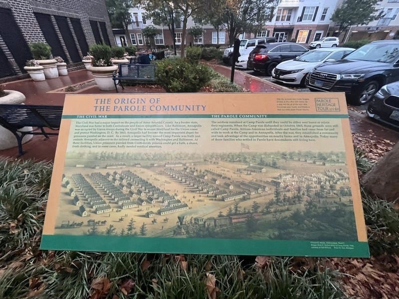
The Origin of the Parole Community
— Parole Heritage Tour —

Photographed By Devry Becker Jones (CC0), September 9, 2023
1. The Origin of the Parole Community Marker
The Civil War
The Civil War had a major impact on the people of Anne Arundel County. As a border state, Maryland was home to both Confederate and Union sympathizers. Like Baltimore, Annapolis was occupied by Union troops during the Civil War to secure Maryland for the Union cause and protect Washington, D.C. By 1863, Annapolis had become the most important depot for prisoners paroled on the coast. As a result, a larger facility named Camp Parole was built just outside Annapolis adjacent to the railroad connecting it with Washington and Baltimore. At these facilities, Union prisoners paroled from Confederate prisons could get a bath, a shave, fresh clothing, and in some cases, badly needed medical attention.
The Parole Community
The soldiers remained at Camp Parole until they could be either sent home or rejoin their regiments. When the Camp was disbanded in October, 1865, these grounds were still called Camp parole. African-American individuals and families had come from far and wide to work at the Camp and in Annapolis. After the war, they established a community and took advantage of the opportunities on nearby farms and in Annapolis. Today many of those families who settled in Parole have descendents still living here.
Erected by Anne Arundle County and the City of Annapolis. (Marker Number 6a.)
Topics. This historical marker is listed in these topic lists: African Americans • Railroads & Streetcars • Settlements & Settlers • War, US Civil. A significant historical month for this entry is October 1865.
Location. 38° 58.771′ N, 76° 31.448′ W. Marker is in Annapolis, Maryland, in Anne Arundel County. It is in Parole. Marker can be reached from West Street (Maryland Route 450) just west of Chinquapin Round Road, on the right when traveling east. Touch for map. Marker is at or near this postal address: 1901 West St, Annapolis MD 21401, United States of America. Touch for directions.
Other nearby markers. At least 8 other markers are within walking distance of this marker. Building Pride into a Community (a few steps from this marker); How Parole Named Its Streets (a few steps from this marker); Parole's Public Schools (approx. 0.2 miles away); Second Baptist Church (approx. 0.2 miles away); Cecil Memorial United Methodist Church (approx. ¼ mile away); Parole Health Center (approx. 0.3 miles away); Mount Olive African Methodist Episcopal Church (approx. 0.3 miles away); You Are Here (approx. 0.4 miles away). Touch for a list and map of all markers in Annapolis.

Photographed By Devry Becker Jones (CC0), September 9, 2023
2. The Origin of the Parole Community Marker
Credits. This page was last revised on December 14, 2023. It was originally submitted on September 10, 2023, by Devry Becker Jones of Washington, District of Columbia. This page has been viewed 143 times since then and 92 times this year. Photos: 1, 2. submitted on September 10, 2023, by Devry Becker Jones of Washington, District of Columbia.