Hughes Springs in Cass County, Texas — The American South (West South Central)
Chalybeate Springs
(Pronounced "Ka líb e ate")
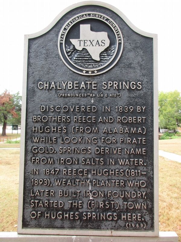
Photographed by Jeff Leichsenring, September 12, 2023
1. Chalybeate Springs Marker
Erected 1969 by State Historical Survey Committee. (Marker Number 9813.)
Topics. This historical marker is listed in this topic list: Settlements & Settlers.
Location. 32° 59.988′ N, 94° 37.818′ W. Marker is in Hughes Springs, Texas, in Cass County. It is at the intersection of 3rd Street and Harrison Street, on the left when traveling west on 3rd Street. The marker is located in Spring Park on 3rd St. (between Ward and Harrison St.). Touch for map. Marker is in this post office area: Hughes Springs TX 75656, United States of America. Touch for directions.

Regionally, this marker is in the American South, specifically in the Deep South, and in the Piney Woods. Globally, it is in North America, a Gulf of Mexico state, the Western Hemisphere, the Western World, and the Anglosphere. Historically,
this page online
Other nearby markers. At least 8 other markers are within 6 miles of this marker, measured as the crow flies: Trammel's Trace (here, next to this marker); Hughes Springs (a few steps from this marker); Caddo Trace (approx. 3.4 miles away); Site of Hussey & Logan's Mill and Gin Factory (approx. 5.8 miles away); Morris County (approx. 5.9 miles away); Rev. Nathan S. Johnson (approx. 5.9 miles away); Daingerfield, C. S. A. (approx. 5.9 miles away); Site of Chapel Hill College (approx. 6 miles away). Touch for a list and map of all markers in Hughes Springs.

Photographed by Jeff Leichsenring, September 12, 2023
2. Chalybeate Springs Marker
The marker is the top of three panels attached to a pole in this view (the middle panel is a dedication tablet).
Credits. This page was last revised on May 4, 2024. It was originally submitted on September 15, 2023, by Jeff Leichsenring of Garland, Texas. This page has been viewed 847 times since then and 80 times this year. Photos: 1, 2. submitted on September 15, 2023, by Jeff Leichsenring of Garland, Texas. • James Hulse was the editor who published this page.
