Summit - University in Saint Paul in Ramsey County, Minnesota — The American Midwest (Upper Plains)
History of Rondo / Redlining Rondo
Professor David Taylor
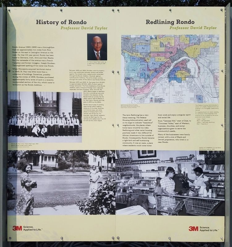
Rondo Avenue (1865–1966) was a thoroughfare than ran approximately two miles from Rice Street on the east to Lexington Avenue on the west. For that 101 year period, Rondo has been home to Germans, Irish, Jews and then Blacks. But the namesake of the avenue was a French Canadian and former voyageur, Joseph Rondeau. The anglicized spelling of his name was Rondo.
When Minnesota acquired territorial status in 1848, St. Paul was little more than a collection of buildings. Sometime, possibly during the winter of 1856, Rondeau purchased approximately forty acres of land in a recently incorporated section of the city, which came to be known as the Rondo Addition.
Dr. David Vassar Taylor grew up in Saint Paul, including at 1016 Rondo.
Between 1859 and 1869, Rondeau sold his property and it was subdivided between several real estate agents. Five streets were created and/or extended through the Rondo Addition: Marshall, Iglehart, Carroll and St. Anthony. The prime street running through the center of this district was Rondo Avenue.
Between 1870 and 1905, St. Paul grew from 20,000 to approximately 197,000–28% of which were of foreign extraction. The first inhabitants of the Rondo Addition were a mixture of foreign-born nationals, especially Germans, Russians, Jews, and Irish. By 1900, Blacks began to abandon the city's commercial core, and moved in the direction of the Rondo Avenue corridor. By the 1930s, about half the Blacks in St. Paul lived in Rondo and that grew to 85% by the 1950s.
Rondo was an area of working class homes within walking distance of churches, factories, commercial areas, and other places of employment in the central core of the city. For example, many Rondo residents worked as Red Caps for the railroad, and walked down the hill to work at the Union Depot.
Above: St. Paul Union Depot Red Caps, 1952
Below: Rondo street scene, 1920s
Residential Security Map for St. Paul, about 1939
The term Redlining has a very literal meaning. The Federal Housing Administration used red on its maps to indicate "hazardous" neighborhoods, the places were home loans would be too risky. Redlining and other racist housing practices made it very difficult for African Americans to live outside of Rondo. Consequently, Rondo became a tight-knit and self-sustaining community. It was an oasis, a place were residents could come home from work and enjoy a singular spirit and social life.
From "Oatmeal Hill," west of Dale, to "Cornmeal Valley," east of Western, businesses, churches, and social organizations grew to serve the community's needs.
Many of the businesses were family owned,
with a mix of Black and Jewish proprietors, who lived in or near Rondo.
The Federal Housing Administration's version of a stable neighborhood was outlined in its mortgage underwriting manual:
If a neighborhood is to retain stability, it is necessary that properties shall continue to be occupied by the same social and racial classes.
Green = "best"
Blue = "still desirable"
Yellow = "definitely declining"
Red = "hazardous"
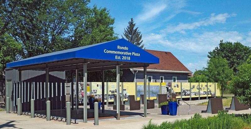
Erected 2018.
Topics. This historical marker is listed in these topic lists: African Americans • Civil Rights • Political Subdivisions • Settlements & Settlers. A significant historical year for this entry is 1856.
Location. 44° 57.057′ N, 93° 8.107′ W. Marker is in Saint Paul, Minnesota, in Ramsey County. It is in Summit - University. Marker is at the intersection of North Fisk Street and Concordia Avenue, on the left when traveling north on North Fisk Street. The marker is at the Rondo Commemorative Plaza. Touch for map. Marker is at or near this postal address: 820 Concordia Avenue, Saint Paul MN 55104, United States of America. Touch for directions.
Other nearby markers. At least 8 other markers are within walking distance of this marker. Karen People in Rondo / Somalis in Rondo (a few steps from this marker); From Service to Solidarity (approx. 0.3 miles away); 10,000 Men Called George (approx. 0.3 miles away); Roots in Rondo (approx. 0.3 miles away); Welcome to Victoria Street Station (approx. 0.4 miles away); Legends of Rondo Neighborhood (approx. 0.4 miles away); Welcome to St. Peter Claver Catholic Church (approx. half a mile away); Welcome to Dale Street Station (approx. half a mile away). Touch for a list and map of all markers in Saint Paul.
Credits. This page was last revised on November 8, 2023. It was originally submitted on September 17, 2023, by McGhiever of Minneapolis, Minnesota. This page has been viewed 80 times since then and 39 times this year. Photos: 1, 2. submitted on September 17, 2023, by McGhiever of Minneapolis, Minnesota. • J. Makali Bruton was the editor who published this page.

