Wild River State Park near Almelund in Chisago County, Minnesota — The American Midwest (Upper Plains)
Military Road
[First panel]
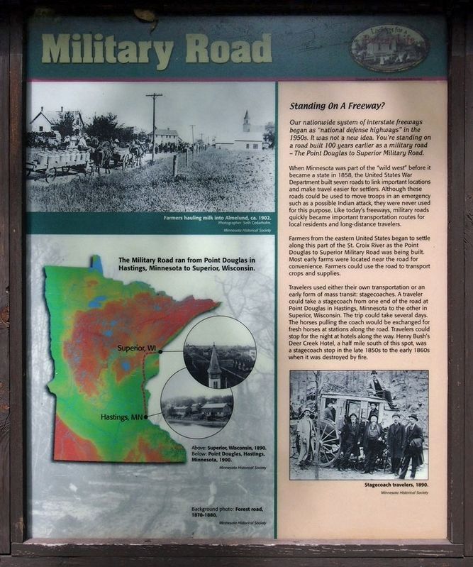
Farmers hauling milk into Almelund, ca. 1902.
Photographer: Seth Cedarholm.
The Military Road ran from Point Douglas in Hastings, Minnesota to Superior, Wisconsin.
Above: Superior, Wisconsin, 1890.
Below: Point Douglas, Hastings, Minnesota, 1900.
Background photo: Forest road, 1870-1880.
Standing On A Freeway?
Our nationwide system of interstate freeways began as "national defense highways" in the 1950s. It was not a new idea. You're standing on a road built 100 years earlier as a military road – The Point Douglas to Superior Military Road.
When Minnesota was part of the "wild west" before it became a state in 1858, the United States War Department built seven roads to link important locations and make travel easier for settlers. Although these roads could be used to move troops in an emergency such as a possible Indian attack, they were never used for this purpose. Like today's freeways, military roads quickly became important transportation routes for local residents and long-distance travelers.
Farmers from the eastern United States began to settle along this part of the St. Croix River as the Point Douglas to Superior Military Road was being built. Most early farms were located near the road for convenience. Farmers could use the road to transport crops and supplies.
Travelers used either their own transportation or an early form of mass transit: stagecoaches. A traveler could take a stagecoach from one end of the road at Point Douglas in Hastings, Minnesota to the other in Superior, Wisconsin. The trip could take several days. The horses pulling the coach would be exchanged for fresh horses at stations along the road. Travelers could stop for the night at hotels along the way. Henry Bush's Deer Creek Hotel, a half mile south of this spot, was a stagecoach stop in the late 1850s to the early 1860s when it was destroyed by fire.
Stagecoach travelers, 1890.
[Second panel]
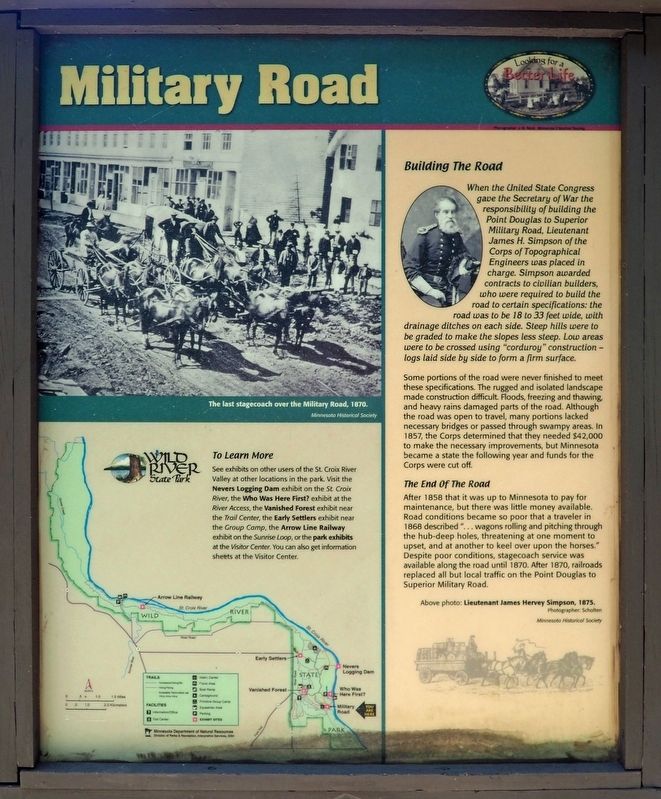
The last stagecoach over the Military Road, 1870.
Building The Road
When the United States Congress gave the Secretary of War the responsibility of building the Point Douglas to Superior Military Road, Lieutenant James H. Simpson of the Corps of Topographical Engineers was placed in charge. Simpson awarded contracts to civilian builders, who were required to build the road to certain specifications: the road was to be 18 to 33 feet wide, with drainage ditches on each side. Steep hills were to be graded to make the slopes less steep. Low areas were to be crossed using "corduroy" construction – logs laid side by side to form a firm surface.
Some portions of the road were never finished to meet these specifications. The rugged and isolated landscape made construction difficult. Floods, freezing and thawing, and heavy rains damaged parts of the road. Although the road was open to travel, many portions lacked necessary bridges or passed through swampy areas. In 1857, the Corps determined that they needed $42,000 to make the necessary improvements, but Minnesota became a state the following year and funds for the Corps were cut off.
The End Of The Road
After 1858 that it was up to Minnesota to pay for maintenance, but there was little money available. Road conditions became so poor that a traveler in 1868 described "...wagons rolling and pitching through the hub-deep holes, threatening at one moment to upset, and at another to keel over upon the horses." Despite poor conditions, stagecoach service was available along the road until 1870. After 1870, railroads replaced all but local traffic on the Point Douglas to Superior Military Road.
Above photo: Lieutenant James Hervey Simpson, 1875.
Photographer: Scholten
[Third panel]
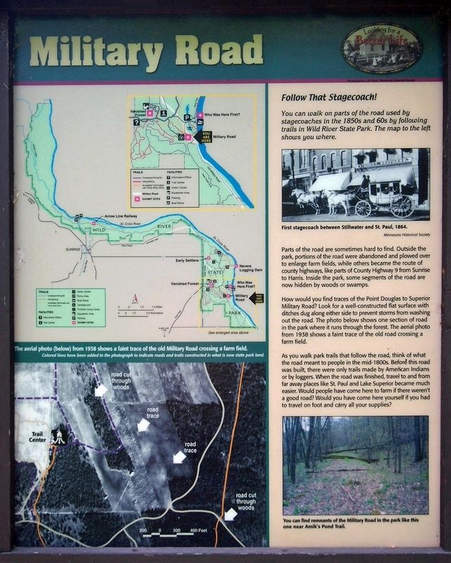
The aerial photo (below) from 1938 shows a faint trace of the old Military Road crossing a farm field.
Colored lines have been added to the photograph to indicate roads and trails constructed in what is now state park land.
Follow That Stagecoach!
You can walk on parts of the road used by stagecoaches in the 1850s and 60s by following trails in Wild River State Park. The map to the left shows you where.
First stagecoach between Stillwater and St. Paul, 1864
Parts of the road are sometimes hard to find. Outside the park, portions of the road were abandoned and plowed over to enlarge farm fields, while others became the route of county highways, like parts of County Highway 9 from Sunrise to Harris. Inside the park, some segments of the road are now hidden by woods or swamps.
How would you find traces of the Point Douglas to Superior Military Road? Look for a well-constructed flat surface with ditches dug along either side to prevent storms from washing out the road. The photo below shows one section of road in the park where it runs through the forest. The aerial photo from 1938 shows a faint trace of the old road crossing a farm field.
As you walk park trails that follow the road, think of what the road meant to people in the mid-1800s. before this road was built, there were only trails made by American Indians or by loggers. When the road was finished,
travel to and from far away places like St. Paul and Lake Superior became much easier. Would people have come here to farm if there weren't a good road? Would you have come here yourself if you had to travel on foot and carry all your supplies?
You can find remnants of the Military Road in the park like this one near Amik's Pond Trail.
Erected by Minnesota Department of Natural Resources.
Topics. This historical marker is listed in these topic lists: Roads & Vehicles • Settlements & Settlers. A significant historical year for this entry is 1853.
Location. 45° 31.17′ N, 92° 44.025′ W. Marker is near Almelund, Minnesota, in Chisago County. It is in Wild River State Park. The marker is in Wild River State Park (fee area), on Amik's Pond Trail east of the visitor center. Touch for map. Marker is in this post office area: Almelund MN 55048, United States of America. Touch for directions.
Other nearby markers. At least 8 other markers are within walking distance of this marker. The St. Croix River (about 300 feet away, measured in a direct line); A Conservation Legacy (about 400 feet away); Restored Prairies (about 400 feet away); Conifer Forests (about 400 feet away); Looking For A Better Life (about 500 feet away); Wild River State Park (about 500 feet away); Who Was Here First?
(approx. 0.3 miles away); What Was It Like (approx. 0.7 miles away). Touch for a list and map of all markers in Almelund.
Credits. This page was last revised on September 20, 2023. It was originally submitted on July 23, 2023, by McGhiever of Minneapolis, Minnesota. This page has been viewed 127 times since then and 33 times this year. Last updated on September 19, 2023, by McGhiever of Minneapolis, Minnesota. Photos: 1, 2, 3, 4, 5. submitted on July 23, 2023, by McGhiever of Minneapolis, Minnesota. • J. Makali Bruton was the editor who published this page.


