Knightstown in Henry County, Indiana — The American Midwest (Great Lakes)
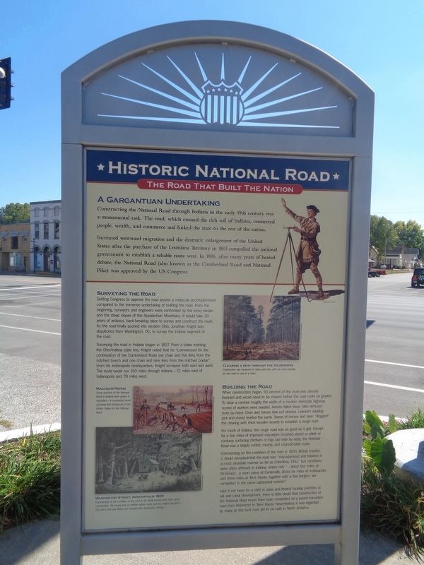
A Gargantuan Undertaking
Historic National Road / Make History, Drive It
— The Road That Built The Nation —
Increased westward migration and the dramatic enlargement of the United States after the purchase of the Louisiana Territory in 1803 compelled the national government to establish a reliable route west. In 1806, after many years of heated debate, the National Road (also known as the Cumberland Road and National Pike) was approved by the US Congress.
Surveying the Road
Getting Congress to approve the road proved a miniscule accomplishment compared to the immense undertaking of building the road. From the beginning, surveyors and engineers were confronted by the rocky terrain and the steep slopes of the Appalachian Mountains. It would take 20 years of arduous, back-breaking labor to survey and construct the route. As the road finally pushed into western Ohio. Jonathan Knight was dispatched from Washington, DC, to survey the Indiana segment of the road.
Surveying the road in Indiana began in 1827. From a stake marking the Ohio/Indiana state line, Knight noted that he "commenced for the continuation of the Cumberland Road one chain and five links from the notched beech and one chain and nine links from the notched poplar." From his Indianapolis headquarters, Knight surveyed both east and west. The route would run 150 miles through Indiana - 72 miles east of Indianapolis and 78 miles west.
Building the Road
When construction began, 90 percent of the route was densely forested and would need to be cleared before the road could be graded. To clear a corridor roughly the width of a modern interstate highway, scores of workers were needed. Axmen felled trees. Men removed roots by hand. Oxen and horses tore out stumps. Laborers wielding pick and shovel leveled the earth. Teams of horses and oxen "dragged" the clearing with thick wooden boards to establish a rough road.
For much of Indiana, this rough road was as good as it got. Except for a few miles of improved macadam (crushed stone) or plank or corduroy surfacing (timbers or logs laid side by side), the National Road was a largely rutted, muddy, and unpredictable route.
Commenting on the condition of the road in 1839, British traveler, J. Gould remarked that the road was "macadamized and finished in a most desirable manner as far as Columbus, Ohio," but conditions were often different in Indiana, where only "…about four miles at Richmond…a short piece at Centerville, about six miles at Indianapolis, and three miles at Terre Haute, together
with a few bridges, are completed in the same substantial manner."
Had it not been for a shift in state and federal funding priorities to rail and canal development, there is little doubt that construction of the National Road would have been completed as a paved macadam road from Richmond to Terre Haute. Nevertheless it was regarded by many as the best road yet to be built in North America.
(photo captions:)
Clearing a Path Through the Wilderness
Construction was measured in chains and rods, with one chain equaling 66 feet (with 4 rods to a chain).
Macadam Paving
Some sections of the National Road in Indiana were paved in macadam - a compacted stone surfacing first introduced in the United States for the National Road.
Washington Street, Indianapolis 1825
Commenting on the condition of the road in his 1838 journal entry, M.H. Jenks commented, "All around was as mother nature made and the Indians had left it…The soil is rich and black and covered with tremendous timber…."
(reverse:)
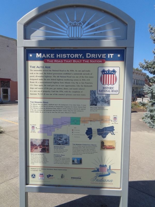
The Auto Age
The automobile revived the National Road in the 1920s. As cars and trucks took to the road, the federal government established a nationwide network of paved, all-weather highways. The old National Road was one of the first routes designated under the new federal highway numbering system in 1926—US Route 40, a transcontinental highway from Atlantic City, NJ, to San Francisco, CA. Once again, the road gave rise to new opportunities. Like the blacksmith shops and taverns of the past, gas stations, diners, and motels ushered in a new era of prosperity. Until the 1970s, with the completion of Interstate 70, US 40 was one of the country's primary east-west routes.
The Modern Road
The National Road has played a significant role in the development of the United States. To honor this distinction, in 2002 the US Secretary of Transportation designated the Historic National Road from Maryland to Illinois an All-American Road. Indiana is actively working to preserve its segment of the road, structures, and landscapes along this historic corridor. Today the road continues to beckon travelers like you as it has for more than 200 years. Welcome to Indiana!
New and Improved
Soon after the turn of the 20th century, Americans abandoned their horses, carts, and interurban rail cars for the independence afforded by the automobile. Old rutted roads like the National Road were paved, new services established, and the modern transportation era began.
Where Service Never Stops
The modern National Road, US Route 40, provided essential services for travelers around the clock.
National Road Landmark
Restored by Historic Landmarks Foundation of Indiana, the 1841 Huddleston Farmhouse in Cambridge City, a popular stopping place for supplies on the old road, continues to welcome visitors along the National Road.
The Modern Conestoga Wagon
The H&C Studebaker blacksmith shop became the Studebaker Manufacturing Company in 1868. Indiana-based Studebaker would eventually become the largest wagon manufacturer in the world. Studebaker introduced an electric car in 1902 and a gasoline powered car in 1904, becoming the only manufacturer to successfully make the transition from horse-drawn to gasoline-powered vehicles.
Erected by Indiana National Road Association.
Topics and series. This historical marker is listed in this topic list: Roads & Vehicles. In addition, it is included in the The Historic National Road series list. A significant historical year for this entry is 1803.
Location. 39° 47.743′ N, 85° 31.498′ W. Marker is in Knightstown, Indiana, in Henry County. Marker is at the intersection of East Main Street (U.S. 40) and North Washington Street, on the right when traveling west on East Main Street. Touch for map. Marker is at or near this postal address: 132 E Main St, Knightstown IN 46148, United States of America. Touch for directions.
Other nearby markers. At least 8 other markers are within 7 miles of this marker, measured as the crow flies. Site of First House in Knightstown (within shouting distance of this marker); Pvt. William Zion USMC (within shouting distance of this marker); Veterans Garden of Memories (within shouting distance of this marker); Revolutionary Soldiers of Henry County (about 700 feet away, measured in a direct line); Knightstown Academy (approx. ¼ mile away); Knightstown Community Veterans Memorial (approx. 0.7 miles away); Glen Cove IOOF Cemetery (approx. ¾ mile away); Underground Station (approx. 6½ miles away). Touch for a list and map of all markers in Knightstown.
Credits. This page was last revised on September 22, 2023. It was originally submitted on September 21, 2023, by Jason Voigt of Glen Carbon, Illinois. This page has been viewed 62 times since then and 10 times this year. Photos: 1. submitted on September 21, 2023, by Jason Voigt of Glen Carbon, Illinois. 2, 3. submitted on September 22, 2023, by Jason Voigt of Glen Carbon, Illinois.


