Terre Haute in Vigo County, Indiana — The American Midwest (Great Lakes)
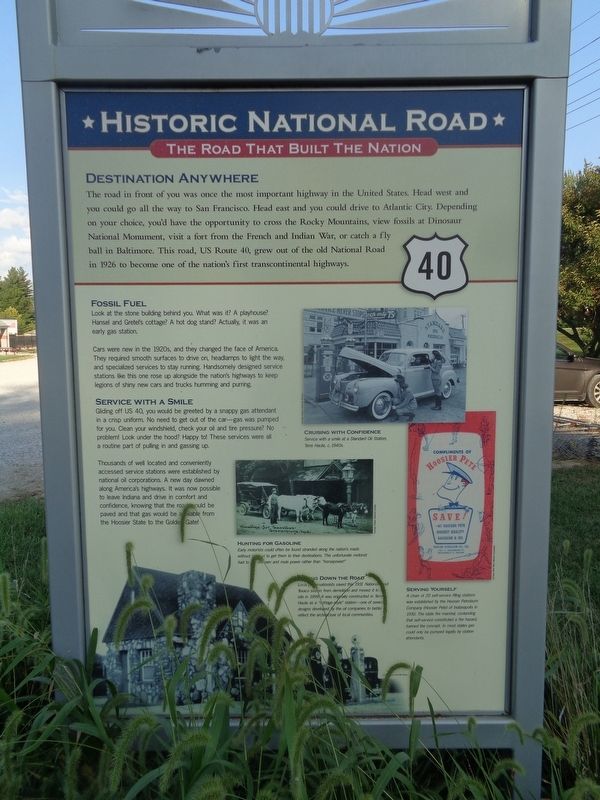
Destination Anywhere
Historic National Road / Make History, Drive It
— The Road That Built the Nation —
Fossil Fuel
Look at the stone building behind you. What was it? A playhouse? Hansel and Gretel's cottage? A hot dog stand? Actually, it was an early gas station.
Cars were new in the 1920s, and they changed the face of America. They required smooth surfaces to drive on, headlamps to light the way, and specialized services to stay running. Handsomely designed service stations like this one rose up alongside the nation's highways to keep legions of shiny new cars and trucks humming and purring.
Service with a Smile
Gliding off US 40, you would be greeted by a snappy gas attendant in a crisp uniform. No need to get out of the car - gas was pumped for you. Clean your windshield, check your oil and tire pressure? No problem! Look under the hood? Happy to! These services were all a routine part of pulling in and gassing up.
Thousands of well located and conveniently accessed service stations were established by national oil corporations. A new day dawned along America's highways. It was now possible to leave Indiana and drive in comfort and confidence, knowing that the road would be paved and that gas would be available from the Hoosier State to the Golden Gate!
(photo captions:)
Hunting for Gasoline
Early motorists could often be found stranded along the nation's roads without the fuel to get them to their destinations. This unfortunate motorist had to (unreadable) oxen and mule power rather than "horsepower!"
(unreadable) Down the Road
Local preservationists saved this 1931 National Road Texaco station from demolition and moved it to this site in 1999. It was originally constructed in Terre Haute as a "cottage-style" station - one of several designs developed by the oil companies to better reflect the architecture of local communities.
Serving Yourself
A chain of 20 self-service filling stations was established by the Hoosier Petroleum Company (Hoosier Pete) of Indianapolis in 1930. The state fire marshal, contending that self-service constituted a fire hazard, banned the concept. In most states gas could only be pumped legally by station attendants.
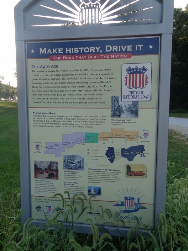
(reverse:) The Auto Age
The automobile revived the National Road in the 1920s. As cars and trucks took to the road, the federal government established a nationwide network of paved, all-weather highways. The old National Road was one of the first routes designated under the new federal highway numbering system in 1926 — US Route 40, a transcontinental highway from Atlantic City, NJ, to San Francisco, CA. Once again, the road gave rise to new opportunities. Like the blacksmith shops and taverns of the past, gas stations, diners, and motels ushered in a new era of prosperity. Until the 1970s, with the completion of Interstate 70, US 40 was one of the country's primary east-west routes.
The Modern Road
The National Road has played a significant role in the development of the United States. To honor this distinction, in 2002 the US Secretary of Transportation designated the Historic National Road from Maryland to Illinois an All-American Road. Indiana is actively working to preserve its segment of the road, structures, and landscapes along this historic corridor. Today the road continues to beckon travelers like you as it has for more than 200 years. Welcome to Indiana!
New and Improved
Soon after the turn of the 20th century, Americans abandoned their horses, carts, and interurban rail cars for the independence afforded by the automobile. Old rutted roads like the National Road were paved, new services established, and the modern transportation era began.
Where Service Never Stops
The modern National Road, US Route 40, provided essential services for travelers around the clock.
National Road Landmark
Restored by Historic Landmarks Foundation of Indiana, the 1841 Huddleston Farmhouse in Cambridge City, a popular stopping place for supplies on the old road, continues to welcome visitors along the National Road.
The Modern Conestoga Wagon
The H&C Studebaker blacksmith shop became the Studebaker Manufacturing Company in 1868. Indiana-based Studebaker would eventually become the largest wagon manufacturer in the world. Studebaker introduced an electric car in 1902 and a gasoline powered car in 1904, becoming the only manufacturer to successfully make the transition from horse-drawn to gasoline-powered vehicles.
Erected by Indiana National Road Association.
Topics and series. This historical marker is listed in these topic lists: Industry & Commerce • Roads & Vehicles. In addition, it is included in the The Historic National Road series list. A significant historical year for this entry is 1926.
Location. 39° 28.764′ N, 87° 19.906′ W. Marker is in Terre Haute , Indiana, in Vigo County. Marker can be reached from Robinwood Lane north of Wabash Avenue (U.S. 40). Marker is located on the grounds of Art Nehf Field, which is part of Rose-Hulman Institute of Technology. Touch for map. Marker is at or near this postal address: 5500 Wabash Ave, Terre Haute IN 47803, United States of America. Touch for directions.
Other nearby markers. At least 8 other markers are within 4 miles of this marker, measured as the crow flies. Rose-Hulman Polytechnic Institute (approx. half a mile away); The Shape of Excellence (approx. half a mile away); Civil War Memorial (approx. ¾ mile away); Highland Lawn Cemetery (approx. 0.9 miles away); Historic National Road / Make History, Drive It (approx. 2 miles away); Max Carey (approx. 2 miles away); Lost Creek (approx. 2½ miles away); Markle Mill Site (approx. 3.4 miles away). Touch for a list and map of all markers in Terre Haute.
Credits. This page was last revised on September 24, 2023. It was originally submitted on September 23, 2023, by Jason Voigt of Glen Carbon, Illinois. This page has been viewed 70 times since then and 17 times this year. Photos: 1, 2, 3. submitted on September 23, 2023, by Jason Voigt of Glen Carbon, Illinois.


