Blooming Grove in Orange County, New York — The American Northeast (Mid-Atlantic)
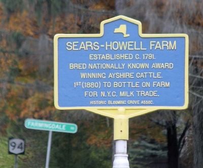
Sears-Howell Farm
Topics. This historical marker is listed in these topic lists: Agriculture • Animals. A significant historical year for this entry is 1791.
Location. 41° 24.049′ N, 74° 12.066′ W. Marker is in Blooming Grove, New York, in Orange County. Marker is at the intersection of New York State Route 94 and Farmingdale Rd, on the right when traveling south on State Route 94. Touch for map. Marker is at or near this postal address: 2952 Rte 94, Blooming Grove NY 10914, United States of America. Touch for directions.
Other nearby markers. At least 8 other markers are within 3 miles of this marker, measured as the crow flies. Presbyterian Congregation of Blooming Grove (approx. 0.2 miles away); Brewster’s Tavern (approx. 0.7 miles away); Brooks' Covered Bridge (approx. 1.9 miles away); Erie Railroad (approx. 2.4 miles away); Moffat Library (approx. 2˝ miles away); Korean and Vietnam Wars Monument (approx. 2˝ miles away); World War I Plaque (approx. 2˝ miles away); World War II Memorial (approx. 2˝ miles away). Touch for a list and map of all markers in Blooming Grove.
Credits. This page was last revised on June 16, 2016. It was originally submitted on October 15, 2009, by Clifton Patrick of Chester, NY, United States. This page has been viewed 1,448 times since then and 33 times this year. Photos: 1, 2. submitted on October 15, 2009, by Clifton Patrick of Chester, NY, United States. • Bill Pfingsten was the editor who published this page.

