Clear Spring in Washington County, Maryland — The American Northeast (Mid-Atlantic)
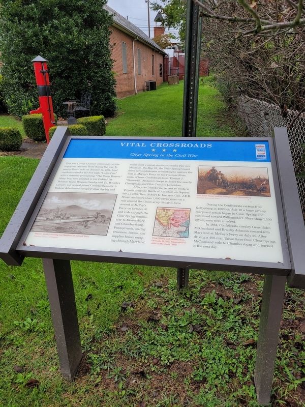
Vital Crossroads
Clear Spring in the Civil War
This was a lively Unionist community on the important National Road during the war. In nearby Four Locks on January 31, 1861, local residents raised a 113-foot-high “Union Pole” with a streamer proclaiming the “Union Forever.”
Many local men enlisted in the Federal 1st Potomac Home Brigade Cavalry and Co. B, Cole’s Cavalry, but several joined the Confederate units. A Federal detachment occupied Clear Spring and maintained a signal station on nearby Fairview Mountain. On May 23, the Clear Spring Guard drove off Confederates attempting to capture the boat at McCoy’s Ferry on the Potomac River, south of here. Confederate Gen. Thomas J. “Stonewall” Jackson’s troops attacked the nearby Chesapeake and Ohio Canal in December.
After the Confederate retreat to western Virginia after the Battle of Antietam on September 17, 1862, Gen Robert E. Lee sent Gen. J.E.B. Stuart and more than 1,000 cavalrymen on a raid around the Union army. Stuart’s force crossed at McCoy’s Ferry on October 10 and rode through the Clear Spring community to Mercersburg and Chambersburg, Pennsylvania, seizing prisoners, horses, and supplies before escaping through Maryland.
During the Confederate retreat from Gettysburg in 1863, on July 10 a large cavalry rearguard action began in Clear Spring and continued toward Williamsport. More than 1,500 cavalrymen were involved.
In 1864, Confederate cavalry Gens. John McCausland and Bradley Johnson crossed into Maryland at McCoy’s Ferry on July 29. After driving a 400-man Union force from Clear Spring. McCausland rode to Chambersburg and burned it the next day.
Topics. This historical marker is listed in this topic list: War, US Civil. A significant historical date for this entry is January 31, 1861.
Location. 39° 39.401′ N, 77° 55.691′ W. Marker is in Clear Spring, Maryland, in Washington County. Marker is at the intersection of Cumberland St. and MillSt., on the right when traveling west on Cumberland St.. Touch for map. Marker is at or near this postal address: 202 Cumberland St, Clear Spring MD 21722, United States of America. Touch for directions.
Other nearby markers. At least 8 other markers are within 3 miles of this marker, measured as the crow flies. A different marker also named Vital Crossroads (a few steps from this marker); A Road Nurtures A Vision (a few steps from this marker); Clear Spring (about 700 feet away, measured in a direct line); Fort Frederick (approx. 0.2 miles away); Clear Spring Veterans Memorial (approx. ¼ mile away); Capt. Samuel G. Prather (approx. 0.6 miles away); The Federal Signal Station (approx. 2.3 miles away); Gen. J. E. B. Stuart’s (approx. 3 miles away). Touch for a list and map of all markers in Clear Spring.
Credits. This page was last revised on October 21, 2023. It was originally submitted on September 24, 2023, by Mike McKeown of Baltimore, Maryland. This page has been viewed 64 times since then and 14 times this year. Photo 1. submitted on September 24, 2023, by Mike McKeown of Baltimore, Maryland. • Bill Pfingsten was the editor who published this page.
