Arnona in Jerusalem, Jerusalem District, Israel — The Middle East (West Asia)
Arnona Neighborhood
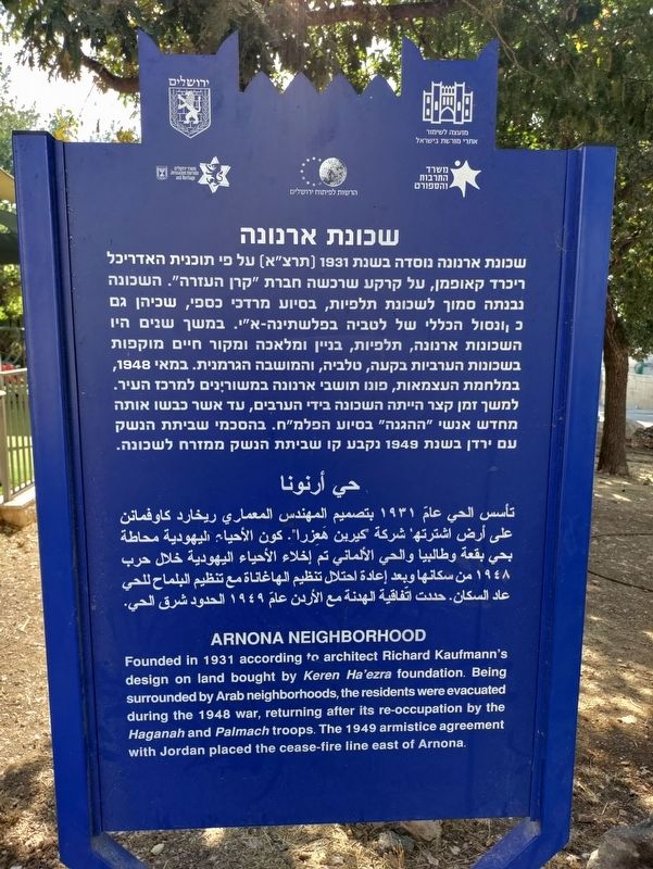
שכונת ארנונה
שכונת ארנונה נוסדה בשנת 1931 [תרצ"א] על פי תוכנית האדריכל ריכרד קאופמן, על קרקע שרכשה חברת "קרן העזרה". השכונה נבנתה סמוך לשכונת תלפיות, בסיוע מרדכי כספי, שכיהן גם כקונסול הכללי של לטביה בפלשתינה-א"י. במשך שנים היו השכונות ארנונה, תלפיות, בניין ומלאכה ומקור חיים מוקפות בשכונות הערביות בקעה, טלביה, והמושבה הגרמנית. במאי 1948, במלחמת העצמאות, פונו תושבי ארנונה במשורינים למרכז העיר. למשך זמן קצר הייתה השכונה בידי הערבים, עד אשר כבשו אותה מחדש אנשי "ההגנה" בסיוע הפלמ"ח. בהסכמי שביתת הנשק עם ירדן בשנת 1949 נקבע קו שביתת הנשק ממזרח לשכונה.
تأسس الحي عام ۱۹۳۱ بتصميم المهندس المعماري ريخارد کاوفمانن على أرض اشترتها شركة كيرين هَعِزرا. كون الأحياء اليهودية محاطة بحي بقعة وطالبيا والحي الألماني تم إخلاء الأحياء اليهودية خلال حرب ١٩٤٨ من سكانها وبعد إعادة احتلال تنظيم الهاغاناة مع تنظيم البلماح للحي عاد السكان. حددت اتفاقية الهدنة مع الأردن عام ١٩٤٩ الحدود شرق الحي.
Founded in 1931 according to architect Richard Kaufmann's design on land bought by Keren Ha'ezra foundation. Being surrounded by Arab neighborhoods, the residents were evacuated during the 1948 war, returning after its re-occupation by the Haganah and Palmach troops. The 1949 armistice agreement with Jordan placed the cease-fire line east of Arnona.
Erected by Council for the Preservation of Israel Heritage Sites.
Topics. This historical marker is listed in these topic lists: Settlements & Settlers • Wars, Non-US. A significant historical year for this entry is 1931.
Location. 31° 44.828′ N, 35° 13.337′ E. Marker is in Jerusalem, Jerusalem District. It is in Arnona. Marker is on Leib Yafe Street, on the right when traveling north. Touch for map. Marker is at or near this postal address: Leib Yafe Street 13, Jerusalem, Jerusalem District, Israel. Touch for directions.
Other nearby markers. At least 8 other markers are within 3 kilometers of this marker, measured as the crow flies. The ancient aqueducts to Jerusalem (approx. 0.4 kilometers away); Ben Yehuda House (approx. 0.6 kilometers away); Departure and Expulsion Memorial (approx. 1.7 kilometers away); The Temple Society People's House (approx. 2.3 kilometers away); Cave 24 (approx. 2.4 kilometers away); Ketef Hinnom (approx. 2.5 kilometers away); The Priestly Blessing (approx. 2.5 kilometers away); Tombs from the First Temple Period (approx. 2.5 kilometers away). Touch for a list and map of all markers in Jerusalem.
Also see . . . Arnona on Wikipedia. (Submitted on September 23, 2023, by Uri Mogilevsky of Jerusalem, Israel.)
Credits. This page was last revised on September 27, 2023. It was originally submitted on September 23, 2023, by Uri Mogilevsky of Jerusalem, Israel. This page has been viewed 62 times since then and 6 times this year. Last updated on September 26, 2023, by Uri Mogilevsky of Jerusalem, Israel. Photo 1. submitted on September 23, 2023, by Uri Mogilevsky of Jerusalem, Israel. • Bill Pfingsten was the editor who published this page.
