
Holden in Millard County, Utah — The American Mountains (Southwest)
Holden
Photographed by Bill Kirchner, October 5, 2013
1. Holden Marker
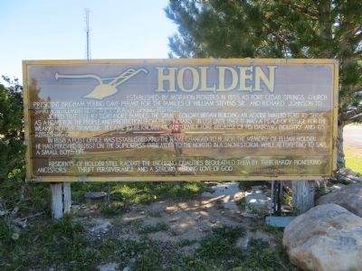
Joined that fall by eight more families, the small colony began construction of an adobe walled fort to serve as a home for the people and protection from Piute Indians. In use until 1867, it was a place of refuge for the weary frontier traveler. It came to be known as "Buttermilk Fort" because of its dairying industry and its refreshing drink.
In 1858 a Post Office was established and the name changed to honor the memory of Elijah Holden. He had perished in 1857 on the Scipio Pass (nine miles to the north) in a snowstorm, while attempting to save a small boy's life.
Residents of Holden still radiate the enduring qualities bequeathed them by their hardy pioneering ancestors...thrift, perseverance, and a strong abiding love of God.
Topics. This historical marker is listed in this topic list: Settlements & Settlers. A significant historical year for this entry is 1855.
Location. 39° 6.505′ N, 112° 16.137′ W.
this page online

Regionally, this marker is in the Central Utah Valleys and in the West Desert. It is also in the American Mountain West and in Colorado Plateau. Globally, it is in North America, the Western Hemisphere, the Western World, and the Anglosphere. Historically, it finds itself in what was once New Spain and also Mexico’s Alta California.
Other nearby markers. At least 8 other markers are within 11 miles of this marker, measured as the crow flies: Cedar Springs Fort (approx. half a mile away); Heritage Bell (approx. half a mile away); Fillmore's Adobe Church (approx. 9.4 miles away); Dominguez - Escalante Trail (approx. 9.4 miles away); Emphasis on Education (approx. 9.4 miles away); Capitol (approx. 9.4 miles away); Fillmore Pioneer Fort (approx. 10.1 miles away); Fillmore Armory (approx. 10.1 miles away). Touch for a list and map of all markers in Holden.
Photographed by Bill Kirchner, October 5, 2013
2. Holden Marker
Credits. This page was last revised on October 3, 2023. It was originally submitted on October 21, 2013, by Bill Kirchner of Tucson, Arizona. This page has been viewed 1,089 times since then and 33 times this year. Last updated on October 2, 2023, by Carl Gordon Moore Jr. of North East, Maryland. Photos: 1, 2. submitted on October 21, 2013, by Bill Kirchner of Tucson, Arizona. • Bill Pfingsten was the editor who published this page.
