Near Spanish Lake in St. Louis County, Missouri — The American Midwest (Upper Plains)
Fort Belle Fontaine
Cantonment Belle Fontaine and Fort Belle Fontaine
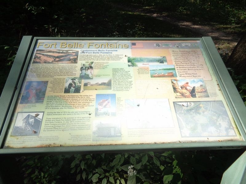
Fort Belle Fontaine, built in 1805, was the first U.S. military post located west of the Mississippi River in the newly acquired Louisiana Territory. A fort was more than a military stronghold; it was a gathering place in the wilderness. This would have been especially true for a fort with an Indian factory (trading post).
There would have been the officers and enlisted men who were garrisoned here (including families of the officers), soldiers of other units that were passing through, settlers from the French and Spanish eras as well as American settlers coming from east of the Mississippi River, people heading West to seek their fortune, trappers and traders, businessmen who had contracts to supply the fort with provisions and supplies and members of the various Native American tribes.
Lt. Col. Daniel Bissell, a Revolutionary War soldier from Connecticut, was given command of the fort in 1809. Finding the fort's buildings in disrepair and recognizing the danger of the fort's location at the bottom of a bluff, Bissell had a new fort built on the bluff which was completed in 1811 and consisted of 30 buildings of hewn logs with stone foundations. Blockhouses and palisades set the fort off in a rectangle atop the Missouri River bluffs.
During the War of 1812 the site was threatened by Native Americans who were in the pay of the English.
Three operations in the summer of 1814 against the British and Sauk-Fox Indians were conducted from Fort Belle Fontaine. In July 1815 soldiers form Fort Belle Fontaine provided security for the Indian council at Portage Des Sioux where representatives of several tribes took part in peace negotiations with the Governor of the Missouri Territory, William Clark.
Originally called Cantonment Belle Fontaine, the fort served as an American Indian factory or trading post for local Sauk-Fox and other Native American tribes. The factory was removed from Fort Belle Fontaine in 1808, with part of the trade goods sent to Fort Osage on the Missouri River (near today's Kansas City) and the remainder shipped up the Mississippi River to Fort Madison in Iowa.
The legendary Lewis and Clark Corps of Discovery expedition camped on a nearby island on May 14, 1804 on the first night of their great journey west. They camped at Fort Belle Fontaine, which was constructed in 1805 while they were still exploring the west, on September 22, 1806, the final night of the expedition before their return to St. Louis.
Lewis and Clark Corps of Discovery Expedition
At 10 am. It seased raining and we collected our party and set out and proceeded on down to
the cantonment, at Coldwater Creek about 3 miles up the Missouri on its southern banks, at this place we found Col. Hunt & a Lieut. Peters and one company of artillerists we were kindly received by the gentlemen at this place. We were honored with a salute of guns and a harty welcome.
Captain William Clark
Monday 22nd of Septr. 1806
Erected by Fort Belle Fontaine Historical Society, Missouri Conservation Department, Saint Louis County Parks and Spanish Lake Community Association.
Topics. This historical marker is listed in these topic lists: Exploration • Forts and Castles • Native Americans • Settlements & Settlers. A significant historical date for this entry is May 14, 1804.
Location. 38° 49.834′ N, 90° 13.117′ W. Marker is near Spanish Lake, Missouri, in St. Louis County. Marker can be reached from Bellefontaine Road. Marker is located off a nature trail on the grounds of Fort Belle Fontaine County Park. Touch for map. Marker is at or near this postal address: 13315 Bellefontaine Rd, Saint Louis MO 63138, United States of America. Touch for directions.
Other nearby markers. At least 8 other markers are within 3 miles of this marker, measured as the crow flies. Belle Fontaine - Beautiful Fountain (approx. ¼ mile away); The Lewis and Clark Expedition (approx. 0.3 miles away); a different marker also named Fort Belle Fontaine (approx. 0.3 miles away); a different marker also named Fort Belle Fontaine (approx. 0.3 miles away); Welcome to Fort Belle Fontaine (approx. 0.4 miles away); Coldwater Creek (approx. half a mile away); Spanish Lake (approx. 2.3 miles away); Columbia Bottom Conservation Area (approx. 2.4 miles away). Touch for a list and map of all markers in Spanish Lake.
Regarding Fort Belle Fontaine. Please note that the marker is accessed only from 8am to the park's closure (30 minutes after sunset). Visitors may be asked to check in with the guards at the park's entrance.
Credits. This page was last revised on October 12, 2023. It was originally submitted on October 11, 2023, by Jason Voigt of Glen Carbon, Illinois. This page has been viewed 57 times since then and 16 times this year. Photos: 1. submitted on October 11, 2023, by Jason Voigt of Glen Carbon, Illinois. 2. submitted on October 12, 2023, by Jason Voigt of Glen Carbon, Illinois.

