Rock Island in Warren County, Tennessee — The American South (East South Central)
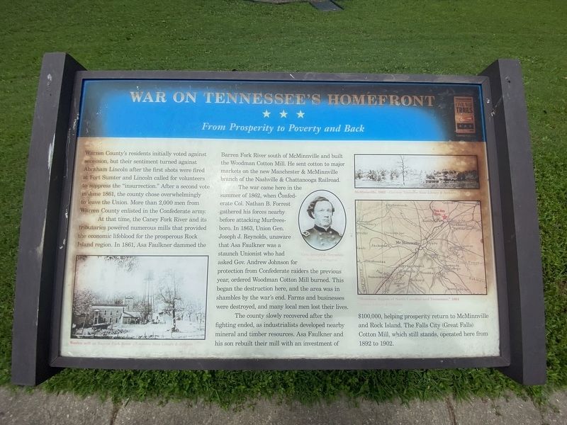
War on Tennessee’s Homefront
From prosperity to poverty and back
Photographed by Darren Jefferson Clay, August 5, 2023
1. War on Tennessee’s Homefront Marker
At that time, the Caney Fork River and its tributaries powered numerous mills that provided the economic lifeblood for the prosperous Rock Island region. In 1861, Asa Faulkner dammed the Barren Fork River south of McMinnville and built the Woodman Cotton Mill. He sent cotton to major markets on the new Manchester & McMinnville branch of the Nashville & Chattanooga Railroad.
The war came here in the summer of 1862, when Confederate Col. Nathan B. Forrest gathered his forces nearby before attacking Murfreesboro. In 1863, Union Gen. Joseph J. Reynolds, unaware that Asa Faulkner was a staunch Unionist who had asked Gov. Andrew Johnson for protection from Confederate raiders the previous year, ordered Woodman Cotton Mill burned. This began the
this page online
The county slowly recovered after the fighting ended, as industrialists developed nearby mineral and timber resources. Asa Faulkner and his son rebuilt their mill with an investment of $100,000, helping prosperity return to McMinnville and Rock Island. The Falls City (Great Falls) Cotton Mill, which still stands, operated here from 1892 to 1902.
Captions
Lower Left: Woolen mill on Barren Fork River - Tennessee State Library & Archive
Center: Gen. Joseph J. Reynolds - Library of Congress
Upper Right: McMinnville 1863 - Tennessee State Library & Archive
Lower Right: "Mountain Region of North Carolina and Tennessee - Library of Congress
Erected by Tennessee Civil War Trails.
Topics. This historical marker is listed in these topic lists: Industry & Commerce • War, US Civil. A significant historical month for this entry is June 1861.
Location. 35° 48.948′ N, 85° 38.839′ W. Marker is on Rock Island, Tennessee, in Warren County. It is on Beach Road half a mile north of Great Falls
Photographed by Darren Jefferson Clay, August 5, 2023
2. War on Tennessee’s Homefront Marker

Regionally, this marker is in Tennessee’s Highland Rim. It is also in the American South and specifically in the Upper South. Globally, it is in North America, the Western Hemisphere, the Western World, and the Anglosphere. Historically, it finds itself in what was once the territory of the Mississippian Culture, one of the Confederate States of America, and the Antebellum South.
Other nearby markers. At least 8 other markers are within 4 miles of this marker, measured as the crow flies: Rock Island State Park (approx. 0.6 miles away); Great Falls HP-Spencer 46-kv Transmission Line (approx. 1.1 miles away); Falls City (Great Falls) Cotton Mill (approx. 1.4 miles away); Spring Castle (approx. 1.4 miles away); “Minnow Box” Springhouse (approx. 1½ miles away); Webb Hotel (approx. 2.3 miles away); Rodgers' Tavern (approx. 2½ miles away); The Old Kentucky Road (approx. 3.2 miles away). Touch for a list and map of all markers in Rock Island.
Credits. This page was last revised on November 11, 2024. It was originally submitted on October 27, 2023, by Darren Jefferson Clay of Duluth, Georgia. This page has been viewed 362 times since then and 32 times this year. Photos: 1, 2. submitted on November 3, 2023, by Darren Jefferson Clay of Duluth, Georgia. • James Hulse was the editor who published this page.
