
Near Grover in Cleveland County, North Carolina — The American South (South Atlantic)
Graham's Fort
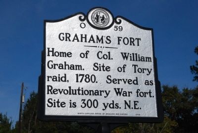
Photographed by Michael Sean Nix, October 22, 2009
1. Graham's Fort Marker
Erected 2008 by North Carolina Office of Archives and History. (Marker Number O-59.)
Topics and series. This historical marker is listed in these topic lists: Forts and Castles • Patriots & Patriotism • War, US Revolutionary. In addition, it is included in the North Carolina Division of Archives and History series list. A significant historical year for this entry is 1780.
Location. 35° 12.285′ N, 81° 29.43′ W. Marker is near Grover, North Carolina, in Cleveland County. It is on Cleveland Avenue (State Highway 226) 0.1 miles north of Garden Lane, on the right when traveling north. Touch for map. Marker is in this post office area: Grover NC 28073, United States of America. Touch for directions.

Regionally, this marker is in North Carolina’s Piedmont. It is also in the American South and specifically in the Upper South. Globally, it is in North America, the Western Hemisphere, the Western World, and the Anglosphere. Historically, it finds itself in what was once the territory of the
this page online
Other nearby markers. At least 8 other markers are within 5 miles of this marker, measured as the crow flies: Cornwallis (approx. 3.4 miles away); Patrick Ferguson (approx. 3.4 miles away); North Carolina / South Carolina (approx. 3.4 miles away); Old Shiloh Presbyterian Church Cemetery (approx. 4.1 miles away); Colonel Frederick Hambright (approx. 4.1 miles away); a different marker also named Old Shiloh Presbyterian Church Cemetery (approx. 4.1 miles away); Kings Mountain Battleground (approx. 4.4 miles away); Welcome to the Blue Ridge National Heritage Area (approx. 4.9 miles away). Touch for a list and map of all markers in Grover.
Additional commentary.
1. History of Graham's Fort from North Carolina Highway Historical Marker Program
Colonel William Graham was born in Virginia in 1742, the son of a Scottish immigrant. He moved to North Carolina prior to the Revolution, settling in Tryon County.
During the Revolutionary War, Colonel Graham lived in a large log-hewn home that was fortified at least to the extent that it was among the safest places to which local people could retreat from enemies. His home was of the type of fort that was scattered about the frontier, offering protection to the pioneers. Graham’s Fort, as it had come to be known, provided shelter from Tory marauders in September 1780. Graham, David Dickey, and Graham’s step-son William Twitty were the only men therein prepared to fight off the attackers. Surviving accounts of the incident vary in details, but there were about two dozen Tories firing shots and demanding the surrender of the fort.
At one point, according to the stories, a Tory named John Burke approached the structure, placed the muzzle of his gun into a crack and discharged the weapon. Seeing this, William Twitty’s seventeen year old sister Susan is said to have pushed her brother down to save him from the bullet. Susan then encouraged William to immediately return the volley out of the aperture as Burke reloaded. Burke was shot through the head. Next, according to legend, Susan Twitty unbolted the door and ran out to retrieve Burke’s gun and ammunition for use by the men in the fort. With Burke dead and others wounded, the Tories withdrew.
— Submitted October 22, 2009, by Michael Sean Nix of Spartanburg, South Carolina.
Credits. This page was last revised on June 16, 2016. It was originally submitted on October 22, 2009, by Michael Sean Nix of Spartanburg, South Carolina. This page has been viewed 2,191 times since then and 53 times this year. Photo 1. submitted on October 22, 2009, by Michael Sean Nix of Spartanburg, South Carolina. • Kevin W. was the editor who published this page.
Editor’s want-list for this marker. A wide shot of the marker and its surroundings. • Can you help?
