Near Fisher’s Hill in Shenandoah County, Virginia — The American South (Mid-Atlantic)
Ramseur's Hill
Fisher’s Hill Battlefield
— Shenandoah Valley Battlefields National Historic District —
Shenandoah at War
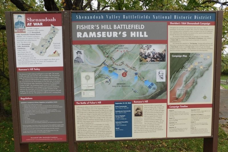
In 1996, Congress designated eight counties as the Shenandoah Valley Battlefields National Historic District, with a mission to preserve and interpret the region's Civil War battlefields and related historic sites. The effort is led by the Shenandoah Valley Battlefields Foundation. Fisher's Hill is one of more than 20 battlefields that are part of the Foundation's work.
To learn more about the battle, the Valley's Civil War story, or to support our efforts, go to www.ShenandoahAtWar.org. To contact the Foundation, call 540-740-4545 or email [email protected].
Ramseur's Hill Today
The Ramseur's Hill walking trail begins to your right. The terrain is hilly, especially after the first, fully-accessible stage. Beyond that stage, the trail becomes steeper, and accessibility is more limited.
The Ramseur's Hill property was originally preserved in 1990 by the Association for the Preservation of Civil War Sites. It was given to the Shenandoah Valley Battlefields Foundation by Shenandoah County in 2007. The Strasburg Guards (Sons of Confederate Veterans Camp # 1587) were integral to the property's protection, and over the years have served as invaluable caretakers of the property. The Guards also created the original interpretive trail and trail guide for the site. The property is still an active, working farm.
The Battle of Fisher's Hill
Following his defeat at Third Winchester, Confederate Gen. Jubal A. Early withdrew here to the imposing defensive position of Fisher's Hill. Unfortunately for Early, he no longer had enough men to defend the four-mile-long defensive line.
Union Gen. Philip H. Sheridan approved a plan to use his VIII Corps to swing around to the west and strike Early's vulnerable left flank. While Gen. George Crook's VIII Corps marched, hidden by darkness and fall foliage, the Union VI and XIX Corps massed north of Fisher's Hill and seized Flint Hill, north of Tumbling Run.
At approximately 4 p.m. on September 22, Crook's two divisions surged "like a western cyclone" toward the Confederate left. Dismounted Confederate cavalry failed to slow the advance, and soon Crook's men rushed into the main line of Confederate infantry-its left flank resting here on Ramseur's Hill. Pressured on the flank and by subsequent frontal assaults from Flint Hill, the Confederate defenses collapsed, and the rebels retreated south along the Valley Pike.
September 21-22, 1864
Union Commander
Gen. Philip H. Sheridan
Confederate Commander
Gen. Jubal A. Early
Forces Engaged
29,444 Union
9,500 Confederate
Estimated Casualties
528 Union
1,235 Confederate
Result
Union Victory
Ramseur's Hill
Ramseur's Hill is a natural high point on Fisher's Hill. (Fisher's Hill is not a single hill, but a collective name for a series of hills and ridges that stretch from the Back Road to the Shenandoah River.) Ramseur's Hill is so named because troops of Confederate Gen. S. Dodson Ramseur's division manned this position during the battle. The hill was a key part of the Confederate defenses and, because of a shortage of troops, extremely vulnerable. The left flank of Gen. Jubal A. Early's infantry rested on this hill. Beyond here, only a thin line of cavalry extended the Confederate defenses northwest past the Back Road.
(Caption):
Confederate Gen. S. Dodson Ramseur. Ramseur image courtesy Portrait Collection, North Carolina Collection Photographic Archives, Louis Round Wilson Special Collections Library, The University of North Carolina at Chapel Hill.
Sheridan's 1864 Shenandoah Campaign
Throughout the Civil War, the Shenandoah Valley had been a "Valley of humiliation" for the North. In August 1864, Union Gen. Philip Sheridan was sent here to bring an end to Confederate control. Uncertain of the size of Confederate Gen. Jubal Early's army, Sheridan was cautious at first, and the initial skirmishes between the forces were small and indecisive.
The situation changed dramatically on September 19, when Sheridan attacked and defeated Early in the Third Battle of Winchester. Early withdrew to Fisher's Hill, but a Federal flank attack on September 22 routed his undermanned forces.
The Federals then embarked on "The Burning," burning mills and barns and destroying or carrying away forage, grain, and livestock. Additional Union victories at Tom's Brook (October 9) and Cedar Creek (October 19) gave the Federals permanent control of the Valley-aiding Abraham Lincoln's reelection and helping speed the surrender of Robert E. Lee at Appomattox the following spring.
Campaign Timeline
August 6
Union Gen. Philip H. Sheridan is made commander of the new Army of the Shenandoah, opposing Confederate Gen. Jubal A. Early's Army of the Valley.
August 16
The two sides fight the small and inconclusive Battle of Guard Hill.
September 3-4
The armies fight another indecisive battle at Berryville.
September 19
Sheridan decisively defeats Early at the bitterly-fought Third Battle of Winchester (#1). The Confederates withdraw to Fisher's Hill.
September 21-22
Early's army is defeated at Fisher's Hill (#2) and retreats south through the Valley.
September 23-October 8
Sheridan moves south to Staunton, then withdraws northward as Union cavalry systematically destroys or confiscates barns, mills, crops, and livestock during "The Burning."
October 9
Federal cavalry units defeat their pursuing southern counterparts at the Battle of Tom's Brook (#3).
October 19
At Cedar Creek (#4), Early's brilliant surprise attack overwhelms much of the Union army, but the Federals rally and counterattack, routing the Confederates and all but destroying Early's command.
Erected by Shenandoah Valley Battlefields Foundation.
Topics. This historical marker is listed in this topic list: War, US Civil. A significant historical year for this entry is 1996.
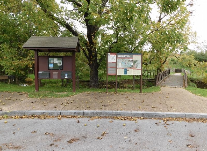
Location. 38° 59.366′ N, 78° 24.872′ W. Marker is near Fisher’s Hill, Virginia, in Shenandoah County. Marker is on Battlefield Road (Virginia Route 601) 0.3 miles east of Tumbling Run Lane, on the right when traveling east. Located at the parking lot for the Ramseur's Hill - Fisher's Hill Battlefield hiking trail. Touch for map. Marker is at or near this postal address: 1847 Battlefield Road, Strasburg VA 22657, United States of America. Touch for directions.
Other nearby markers. At least 8 other markers are within walking distance of this marker. Fisher's Hill (about 300 feet away, measured in a direct line); Battle of Fisher’s Hill (about 800 feet away); a different marker also named Fisher’s Hill (approx. 0.2 miles away); a different marker also named Fisher’s Hill (approx. ¼ mile away); a different marker also named Fisher’s Hill (approx. ¼ mile away); a different marker also named Fisher’s Hill (approx. 0.3 miles away); a different marker also named Fisher's Hill (approx. 0.3 miles away); a different marker also named Fisher’s Hill (approx. 0.3 miles away).
Credits. This page was last revised on November 12, 2023. It was originally submitted on November 10, 2023, by Bradley Owen of Morgantown, West Virginia. This page has been viewed 94 times since then and 44 times this year. Photos: 1, 2, 3. submitted on November 12, 2023, by Bradley Owen of Morgantown, West Virginia.


