Eijsden in Eijsden-Margraten, Limburg, Netherlands — Northwestern Europe
Von Dorpsstraat tot Diepstraat / From Dorpsstraat to Diepstraat
Inscription.
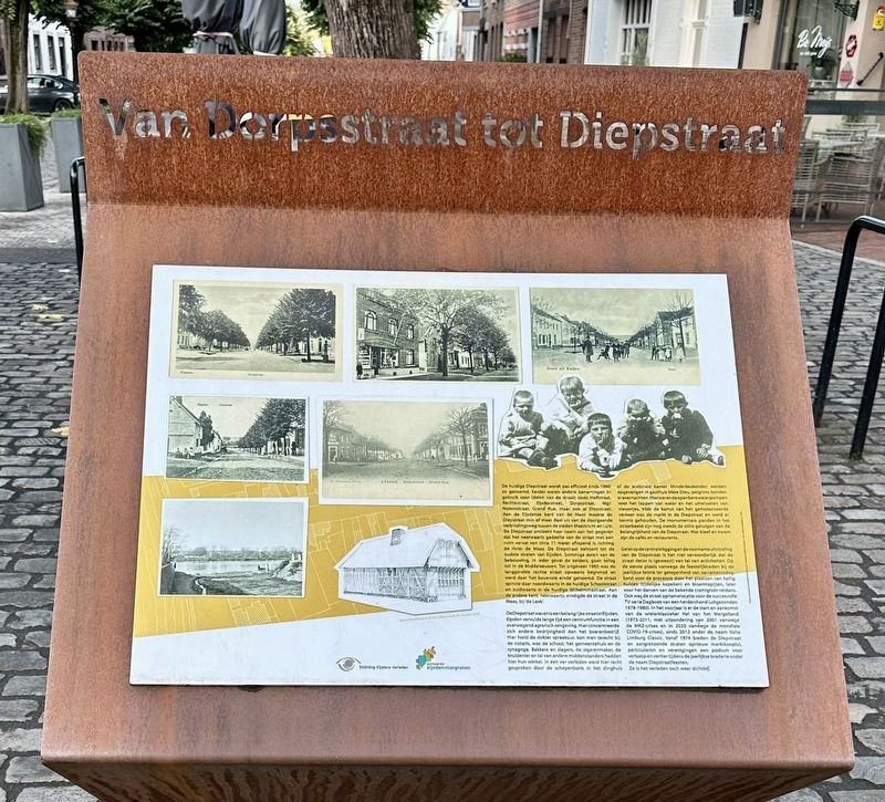
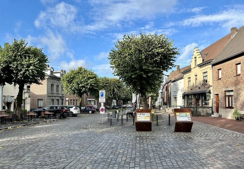
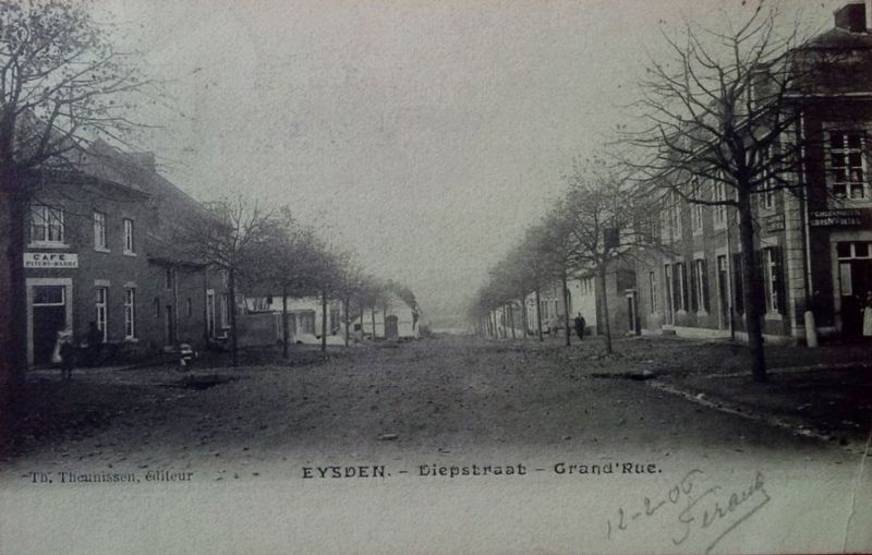
De huidige Diepstraat wordt pas officieel sinds 1960 zo genoemd. Eerder waren andere benamingen in gebruik voor (delen van de straat) zoals Halfstraat, Rechtestraat, Eijsderstraat, Dorpsstraat, Mgr. Nolensstraat, Grand Rue, maar ook al Diepstraat. Aan de Eijsdense kant van de Maas maakte de Diepstraat min of meer deel uit van de doorgaande verbindingsweg tussen de steden Maastricht en Luik. De Diepstraat ontleent haar naam aan het gegeven dat het neerwaarts gedeelte van de straat met een ruim verval van circa 11 meter aflopend is richting de rivier de Maas. De Diepstraat behoort tot de oudste straten van Eijsden. Sommige delen van de bebouwing, in ieder geval de kelders, gaan terug tot in de Middeleeuwen. Tot ongeveer 1960 was de langgerekte rechte straat opwaarts begrensd en werd daar 'het bovenste einde' genoemd. De straat splitste daar noordwaarts in de huidige Schoolstraat en zuidwaarts in de huidige Wilhelminastraat. Aan de andere kant, neerwaarts, eindigde de straat in de Maas, bij 'de Laak'.
De Diepstraat was en is een belangrijke straat in Eijsden. Eijsden vervulde lange tijd een centrumfunctie in een overwegend agrarisch omgeving. Hier concentreerde zich andere bedrijvigheid dan het boerenbedrijf. Hier hield de dokter spreekuur, kon men terecht bij de notaris, was de school, het gemeentehuis en de synagoge. Bakkers en slagers, de sigarenmaker, de kruidenier en tal van andere middenstanders hadden hier hun winkel. In een ver verleden werd hier recht gesproken door de schepenbank in het dinghuis of de scabinale kamer. Minderbedeelden werden. opgevangen in gasthuis Mère Dieu, pelgrims konden erovernachten. Hierwaren de openbare waterpompen voor het tappen van water en het uitwisselen van nieuwtjes. Vóór de komst van het gemotoriseerde. verkeer was de markt in de Diepstraat en werd er kermis gehouden. De monumentale panden in het straatbeeld zijn nog steeds de stille getuigen van de belangrijkheid van de Diepstraat. Wat bleef en kwam zijn de cafés en restaurants.
Gelet op de centrale ligging en de voorname uitstraling van de Diepstraat is het niet verwonderlijk dat de straat decor is (geweest) van tal van activiteiten. Op de eerste plaats vanwege de feestelijkheden bij de jaarlijkse bronk ter gelegenheid van sacramentsdag. Eerst voor de processie door het plaatsen van heilig huisjes (tijdelijke kapellen) en bloemtapijten, later voor het dansen van de bekende cramignon-reidans. Ook was de straat opnamelocatie voor de succesvolle TV-serie
Dagboek van een herdershond (uitgezonden
1978-1980). In het voorjaar is er de start en aankomst
van de wielerklassieker Hel van het Mergelland
(1973-2011; met uitzondering van 2001 vanwege
de MKZ-crises en in 2020 vanwege de mondiale COVID-19-crises), sinds 2012 onder de naam Volta Limburg Classic. Vanaf 1974 bieden de Diepstraat en aangrenzende straten opnieuw marktkooplui, particulieren en verenigingen een podium voor verkoop en vertier tijdens de jaarlijkse braderie onder
de naam Diepstraatfeesten.
Zo is het verleden toch weer dichtbij.
The current Diepstraat has only been officially called that since 1960. Previously, other entries were in use for (parts of the street) such as Halfstraat, Rechtestraat, Eijsderstraat, Dorpsstraat, Mgr. Nolensstraat, Grand Rue, but also Diepstraat. On the Eijsden side of the Maas River, the Diepstraat was more or less part of the main connecting road between the cities of Maastricht and Liège. The Diepstraat takes its name from the fact that the downward part of the street slopes towards the river Maas with a large gradient of approximately 11 meters. Diepstraat is one of the oldest streets in Eijsden. Some parts of the construction, at least the cellars, date back to the Middle Ages. Until about 1960, the elongated straight street had an upward limit and was called 'the maximum end'. The street split north into the current Schoolstraat and south into the current Wilhelminastraat. On the other side, downwards, the street extends into the Maas, at 'de Laak'.
The Diepstraat was and is an important street in Eijsden. Eijsden fulfilled a central function for a long time in a predominantly agricultural environment. Activities other than farming were concentrated here. This is where the doctor held consultation hours, where the notary could be consulted, where the school, the town hall and the synagogue were located. Bakers and butchers, the cigar maker, the grocer and many other tradesmen had their shops here. In the distant past, justice was administered here by the aldermen's bench in the administrative building or the cabinet room. Less fortunate people were accommodated at the Mère Dieu guesthouse, and pilgrims could spend the night there. Here were the public water pumps for tapping water and exchanging news. Before the arrival of motorized traffic, the market was held on Diepstraat and a fair was also held there. The monumental buildings in the street scene are still silent witnesses to the importance of Diepstraat. What came and remained are the cafes and restaurants.
Given the central location and the distinguished appearance of the Diepstraat, it is not surprising that the street is (or has been) the setting for numerous activities. First of all because of the festivities at the annual spring on the occasion of Corpus Christi (lit. “Sacrament Day”). First for the procession by placing sacred houses (temporary chapels) and flower carpets, later for dancing the famous cramignon dance. The street was also a shooting location for the successful TV series Dagboek van een herdershond (“Diary of a Sheepdog”, broadcast 1978-1980). In the spring there is the start and finish of the cycling classic Hel van het Mergelland (1973-2011; with the exception of 2001 due to the Foot and Mouth crises and in 2020 due to the global COVID-19 crises), since 2012 under the name Volta Limburg Classic. From 1974 onwards, the Diepstraat and adjacent streets once again offer market traders, private individuals and associations a stage for sales and entertainment during the annual fair under the name Diepstraatfeesten (“Diepstraat festival”).
And so the past is once again close.
Erected by Stichting Eijsdens Verleden, Gemeente Eijsden-Margraten.
Topics. This historical marker is listed in these topic lists: Industry & Commerce • Roads & Vehicles • Settlements & Settlers.
Location. 50° 46.524′ N, 5° 42.219′ E. Marker is in Eijsden, Limburg, in Eijsden-Margraten. Marker is at the intersection of Diepstraat and Schoolstraat, on the right when traveling west on Diepstraat. Touch for map. Marker is at or near this postal address: Diepstraat 2, Eijsden, Limburg 6245 CA, Netherlands. Touch for directions.
Other nearby markers. At least 8 other markers are within walking distance of this marker. Aan de Laak / At the Border Water (here, next to this marker); Petrus Wolfs (about 210 meters away, measured in a direct line); Eijsden - Gronsveld Holocaust Memorial - De Breuk (“The Break”) (about 240 meters away); Verzetsmonument Eijsden / Resistance Memorial Eijsden (approx. 0.2 kilometers away); Sint Christinakerk / Saint Christina Church (approx. 0.3 kilometers away); Het Veldje / The Field (approx. 0.3 kilometers away); Vlucht naar de vrijheid / Flight to Freedom (approx. 0.3 kilometers away); Opvang Belgische vluchtelingen / Asylum for Belgian Refugees (approx. 0.6 kilometers away). Touch for a list and map of all markers in Eijsden.
Credits. This page was last revised on November 15, 2023. It was originally submitted on November 15, 2023, by Andrew Ruppenstein of Lamorinda, California. This page has been viewed 40 times since then and 8 times this year. Photos: 1, 2, 3. submitted on November 15, 2023, by Andrew Ruppenstein of Lamorinda, California.


