Phillips in Minneapolis in Hennepin County, Minnesota — The American Midwest (Upper Plains)
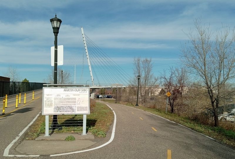
Martin Olav Sabo Bridge
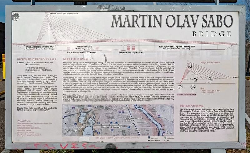
Tower Mast: 100' Above Deck
West Approach: 2 Spans 110'
Reinforced Concrete Deck Bridge
Main Span: 215'
Cable-Stayed Bridge
East Approach: 7 Spans Totaling 357'
Reinforced Concrete Deck Bridge
Congressman Martin Olav Sabo
Career: 1961-1978 Minnesota House of Representatives
1979-2006: US House of Representatives: Fifth District, Minnesota
With more than four decades of elective public service Congressman Martin Olav Sabo has "distinguished himself through a long and honored tenure in the House," according to the Minneapolis Star Tribune.
Martin Sabo has been a strong supporter of mass transit, pedestrian and bicycle programs over his tenure. He has been instrumental in obtaining the Federal funding necessary to construct the Hiawatha Corridor light rail transit line which this bridge crosses to the East. He also played a critical role in obtaining Federal funding necessary to construct the Midtown Greenway trail system of which this bridge is a key element.
Martin Olav Sabo completed his fourteenth term in Congress in December, 2006.
Cable-Stayed Bridge
The bridge before you is a cable-stayed bridge. It may look similar to a suspension bridge, but the two bridges support their deck loads in very different ways. The difference lies in how the cables are connected to the towers, transmitting the deck load to anchorages at either end. In cable-stayed bridges, the cables are attached to the towers. "Balanced" cable-stayed bridges include symmetrical decks on either side of the support tower. The Martin Olav Sabo Bridge is unique in that the weight of the main span is supported by "back stay" cables which are anchored into large concrete blocks on both sides of the deck. These massive blocks are attached to the limestone bedrock 50 feet below ground using a series of rock anchors which in combination with the concrete blocks resist the uplift force of the back stay cables.
In addition to the large vertical forces, cable-stayed bridges create very large horizontal forces in the deck comparable in scale to vertical forces. These compressive forces acting in the deck from east to west handle the compression forces in the deck more efficiently. A similar but opposing horizontal force is transferred to the large concrete blocks which are being pulled together by the action of the cables. This compressive force is resisted by three underground reinforced concrete structs which form a triangular pattern between the main pier and the two concrete earth anchor blocks. The bridge force diagram at the right illustrates the interaction of the main cable-stayed
bridge elements. The bridge spans east and west of the main span are designed with slender decks to compliment [sic] the cable-stayed deck.
Although cable-stayed bridges may look modern, the original idea for them began hundreds of years ago. The first known sketch of a cable-stayed bridge appears in a book called Machinae Novae published in 1595, but it wasn't until this century that this bridge style became feasible to engineer and construct. Cable-Stayed bridges have begun to be erected in the United States only recently. The Martin Olav Sabo bridge is the first of its type to be constructed in the State of Minnesota.
Midtown Greenway
The Midtown Greenway trail system runs over 5 miles from Minneapolis' Chain of Lakes Regional Park to the Mississippi River. The Greenway is much more than a traditional trail. Utilizing an abandoned freight corridor, it provides for safe movement of bicycles and pedestrians for commuting and recreation with minimal street crossings 24 hours a day, 365 days a year. Through the work of Hennepin County, MnDOT and the City of Minneapolis, the trail system is becoming a beautifully landscaped ribbon connecting neighborhoods, employment centers, schools and parks while spurring redevelopment of adjacent land. The Greenway Corridor is illustrated along the bottom of the panel.
Project Credits
Agency Responsible for Design and Construction: Hennepin County
Owner: City of Minneapolis
Engineering Consultant: URS Corporation
Construction Contractor: Ames Construction
Design Period: 12 Months
Construction Period: 10 Months
Funding: U.S. Government, Hennepin County
Partner Agencies: MnDOT, Metropolitan Council
Topics. This historical marker is listed in these topic lists: Bridges & Viaducts • Government & Politics • Parks & Recreational Areas • Railroads & Streetcars. A significant historical month for this entry is December 2006.
Location. 44° 57.195′ N, 93° 14.593′ W. Marker is in Minneapolis, Minnesota, in Hennepin County. It is in Phillips. Marker is on the Midtown Greenway west of Hiawatha Avenue (Minnesota Highway 55). Touch for map. Marker is at or near this postal address: 2020 E 28th Street, Minneapolis MN 55407, United States of America. Touch for directions.
Other nearby markers. At least 8 other markers are within walking distance of this marker. 2107 East Lake: Porky's Drive-In (approx. 0.3 miles away); 2019 East Lake: Burma Shave (approx. 0.3 miles away); Minneapolis Pioneers and Soldiers Memorial Cemetery (approx. 0.4 miles away); Layman's Farmhouse / Casa de Campo Layman (approx. 0.4 miles away); 2108-30 East Lake: Twin City Rapid Transit Lake Street Station and Car Yard (approx. 0.4 miles away); 2217 East Lake: Axel's Lunch Room (approx. 0.4 miles away); Hiawatha-Minnehaha Corridor (approx. 0.4 miles away); The CM&StP & the South Side (approx. half a mile away). Touch for a list and map of all markers in Minneapolis.
Also see . . . Martin Olav Sabo Bridge on Wikipedia. (Submitted on November 21, 2023, by McGhiever of Minneapolis, Minnesota.)
Credits. This page was last revised on November 22, 2023. It was originally submitted on November 21, 2023, by McGhiever of Minneapolis, Minnesota. This page has been viewed 47 times since then and 8 times this year. Photos: 1, 2. submitted on November 21, 2023, by McGhiever of Minneapolis, Minnesota. • J. Makali Bruton was the editor who published this page.

