Delhi in Norfolk County, Ontario — Central Canada (North America)
Main Street
(Between Church Street and King Street)
[photo captions]
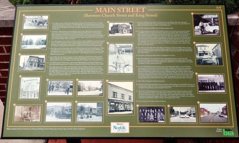
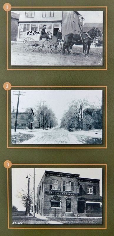
1. Circa 1900, west side of Main Street, Ross Eitel, the butcher, with his delivery of meat, is leading a team of horses in front of the office of "The Delhi Reporter". The cash and carry grocery store of Sam and Charlie Hickling hasn't been built yet to the right. Note picture #4. The barn in the background, is the side view of the Stoddard's Hotel and Livery Stables. The front end, not seen, faces the south side of King Street.
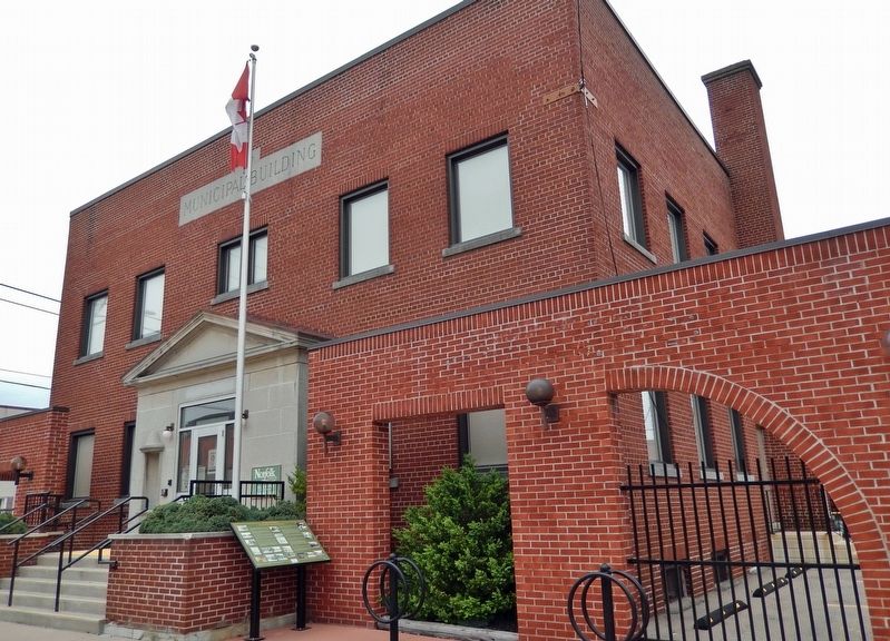
2. December 6, 1906, during an ice storm looking south (east side of Main Street at Church Street), the two story wood frame building is the HS Pettit Blacksmith Shop, built circa 1873. 2017, the Delhi Administration Building, former Delhi Municipal Hall, is on the same site. 1873, HS Pettit Blacksmith business card read, "horse shoeing and job shop, particular attention paid to interfering and contracted feet". 1896, the village's 1860 hand pump fire engine was stored here. The west side of the street is Dr. RW Tisdale's office and residence.
3. Circa 1910, northwest corner of Main and Church Streets, the Bank of Hamilton was built and opened on June 1, 1898. Left, the bank, right, the bank manager's residence. Delhi's second newspaper, "The Vindicator", reported Friday, December 29, 1899, "The Bank of Hamilton had office hours in Delhi from 10:00am to 3:00pm Monday, Wednesday and Friday only for the present J. Butterfield agent".
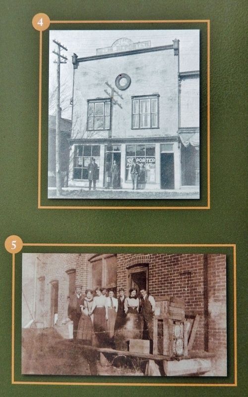
4. Circa 1910, west side of Main Street, built in the 1880s, the sign at the top of the building says "Office of the Delhi Reporter". Sam Hickling, the printer, is standing in the doorway. Minnie, Maude and Ada Hickling had a millinery (designing of women's hats) above the Delhi Reporter at one time. Right part of the store was run by Sam and his brother Charlie. This building was torn down in November 2000, due to a previous fire.
5. Prior to 1912, this is the alleyway facing the west side of Main Street, behind the First Morgan Block. When it burned, the Second Morgan Block was built, facing King Street, and is the site of the Bank of Montreal, 2017. Far left, is Tom Morgan, sixth from right, Harry Morgan, owner of the hardware store.
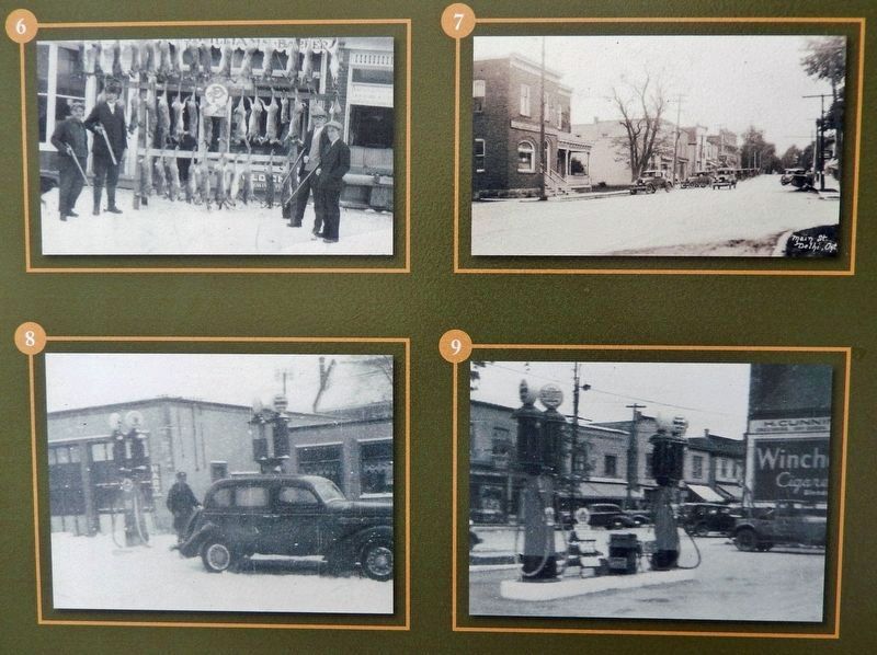
6. Circa 1930s, east side of Main Street, in front of Ross William's billiards, (later Jack's Pool Room). A day of successful hunting produced 41 rabbits. Far right, James Mussel. (home of the Java Bean in 2017)
7. Circa 1932, looking north at Main and Church Streets. The first building on the west side, the former Bank of Hamilton, which amalgamated with the Bank of Commerce in January 1924; second, a drug store built originally, and owned by, G. G. Byers from 1914-1929, then operated by Thomas E. Gingell from 1929-1932, partly used as an insurance office and post office; third, Edgar Birdsall's shoe store; fourth, "The Delhi Reporter", Delhi's first newspaper; fifth, unidentified; sixth, Joe Brooks, "Semi-ready Tailoring"; seventh, the Bank of Montreal.
8. Circa 1935, northeast corner of Main and Church Streets, the Milburn "Mel" Kramer Supertest gasoline service station, with two bay mechanical garage, left, and office/parts store, right. Built in the 1920s and operated until the late 1940s. Gord Bertling in photo.
9. Circa 1935, looking west, Milburn Kramer Garage's gasoline pumps.
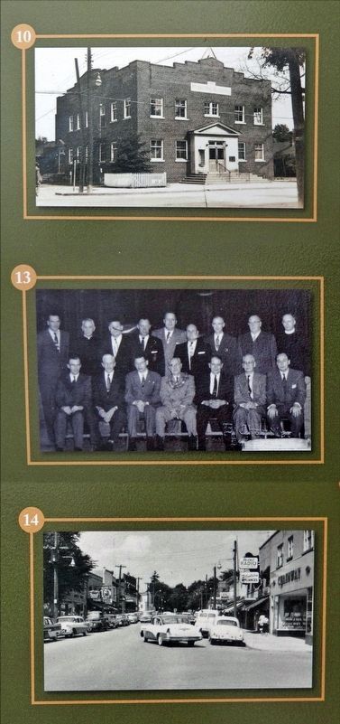
10. Circa 1940s, facing the east side of Main and Church Streets, this location was purchased for $2300, cost $28,000 to build. First floor, front left side, originally the municipal office. Exterior left side, a public drinking fountain. Right side, the Post Office until 1950, then relocated to Church Street. The Public Utilities Commission moved into the former Post Office space until 1966, then relocated to Church Street. Second floor, consisted of an auditorium, where the Delhi Community Band practised. Later, it became the council chambers and Delhi Women's Institute meeting room. The two bay fire hall was located in the northeast corner of the building facing Church Street. First police station side door is leading to the basement, to one jail cell. The basement was later used by the Cubs, Brownies and Girl Guides and provided public washrooms. A 1950 one story addition, at the southeast corner, housed a second police station.
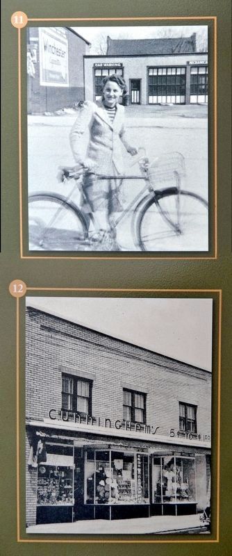
11. Circa 1942, east side of Main Street, Bea (Morgan) Hickling is in front of the Milburn Kramer garage. A car washing bay door, left, two mechanic bay doors, right. Left, the H. Cunningham groceries and dry goods store remains (refaced), in 2017. The roofline behind the service station garage is the old Methodist, later, United Church.
12. Circa 1945, mid west side of Main Street, Cunningham's 5˘ - $1 store.
13. Mid 1950s Delhi Town Council: Back row, left to right; John Hanselman, Fr. John Uyen, Jack Kinchsular, Arn Sayeau, George Reynaert, Lyle Coyle, Wilf Spicer, Emerson Spence, Rev. S. Sharples. Front row, left to right; "Evans" Knowles, Walt Bernard, Ralph Wilson, Lorne Burch (first town mayor), Ted Philips, Dr. Bruce Gerhard, Jack Warell.
14. Circa mid 1950s (looking north) east side: first store, Chainway (built in 1950, as one of 9 Chainway department stores in Southwestern Ontario) Delhi Radio and Kelleher's Menswear, all occupying the former Millburn Kramer Garage site; fourth, Cunningham's Shoes; fifth, unidentified; sixth, C.I.L Paints/Carroll Brothers' Hardware Store; seventh, unidentified; eighth, Ross Williams' Billiard Parlour/Ice Cream; ninth, unidentified; tenth, Heath's Menswear (King and Main); west side: first store, (Harold) Taylor's Rexall Drugs, 1932-1965, included soda fountain service; second, Dick & Gord Quance Super IGA Market; third, Fernlea Flowers, owned by Lloyd Veit, purchased in November 1961; other half of building, Dalton Shine's Stationery/Music Store; fifth, unidentified Cleaners; sixth, Bank of Montreal.
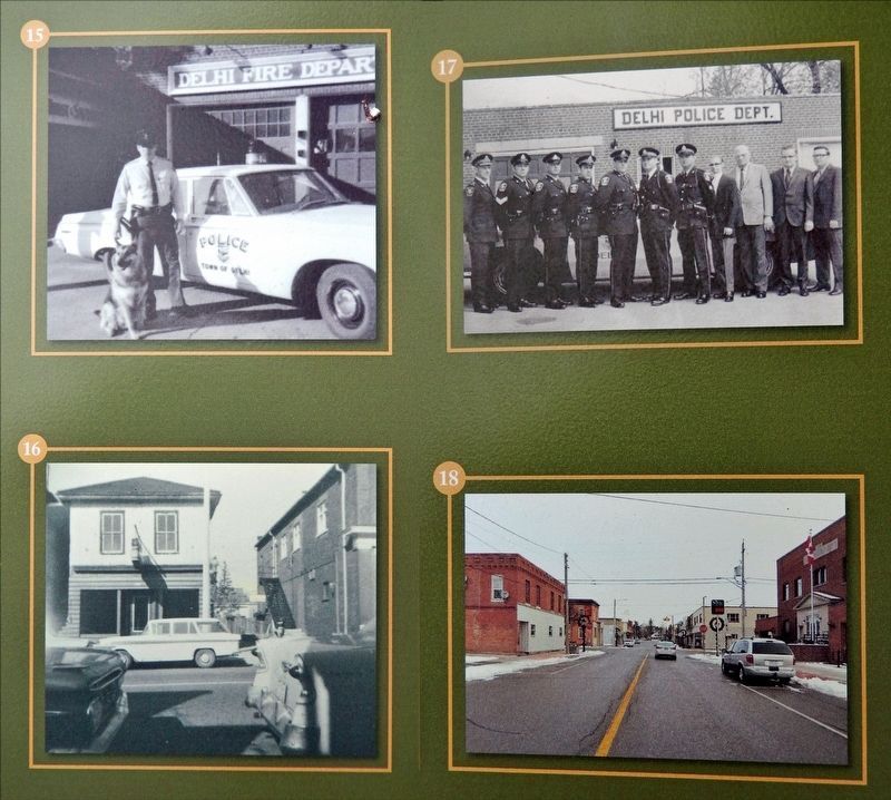
15. 1964, Albert Vandepoele with police dog, Rocky.
16. October 14, 1964, west side of Main Street, the last use of this building was unidentified Cleaners, and was torn down in 1964-65 where it, and the small empty lot to the right, made way for a store addition to Caffery's Home Hardware, also facing Main Street, 2017.
17. 1974 (built in 1950), looking east, the second Police Station had four double cells, police and chief offices, a garage for the police car. In 1950, approval was given to buy a police cruiser. Previously, the officers used their own cars. "The Tobacco Force", left to right, Chief Lee Stewart, SGT. Albert Vandepoele, Constables Jack Fogolton, Robert "Bob" Gooding, Jim Evans, Harold Lee, Larry Beattie. Dispatchers, Harold Brown, William Dennis, Stan Saunders, Dave Smith.
18. 2016, looking north at Main and Church Streets.
Photos courtesy of: Diane Bertling, Bea (Morgan) Hickling, Mark Nettling, Dave Rusnak, Spence Family, Albert Vandepoele
Erected 2018 by Norfolk County; and Delhi BIA.
Topics. This historical marker is listed in these topic lists: Architecture • Charity & Public Work • Industry & Commerce • Law Enforcement.
Location. 42° 51.265′ N, 80° 29.904′ W. Marker is in Delhi, Ontario, in Norfolk County. Marker is on Main Street of Delhi just south of Church Street West, on the right when traveling north. The marker is located along the sidewalk, on the south side of the Delhi Administration Building entrance. Touch for map. Marker is at or near this postal address: 183 Main Street of Delhi, Delhi ON N4B 2M2, Canada. Touch for directions.
Other nearby markers. At least 8 other markers are within 16 kilometers of this marker, measured as the crow flies. Church Street Fire Hall (within shouting distance of this marker); Multicultural Heritage Association of Norfolk (within shouting distance of this marker); a different marker also named Main Street (about 90 meters away, measured in a direct line); a different marker also named Main Street (about 150 meters away); Delhi District German Home (approx. 0.8 kilometers away); Sergeant Frederick Hobson, V.C. (approx. 15.7 kilometers away); Norfolk County Court-House and Gaol (approx. 15.8 kilometers away); Simcoe (approx. 15.9 kilometers away). Touch for a list and map of all markers in Delhi.
Credits. This page was last revised on November 28, 2023. It was originally submitted on November 28, 2023, by Cosmos Mariner of Cape Canaveral, Florida. This page has been viewed 103 times since then and 58 times this year. Photos: 1, 2, 3, 4, 5, 6, 7, 8. submitted on November 28, 2023, by Cosmos Mariner of Cape Canaveral, Florida.
