York in York County, South Carolina — The American South (South Atlantic)
Historic York, S.C.
Inscription.
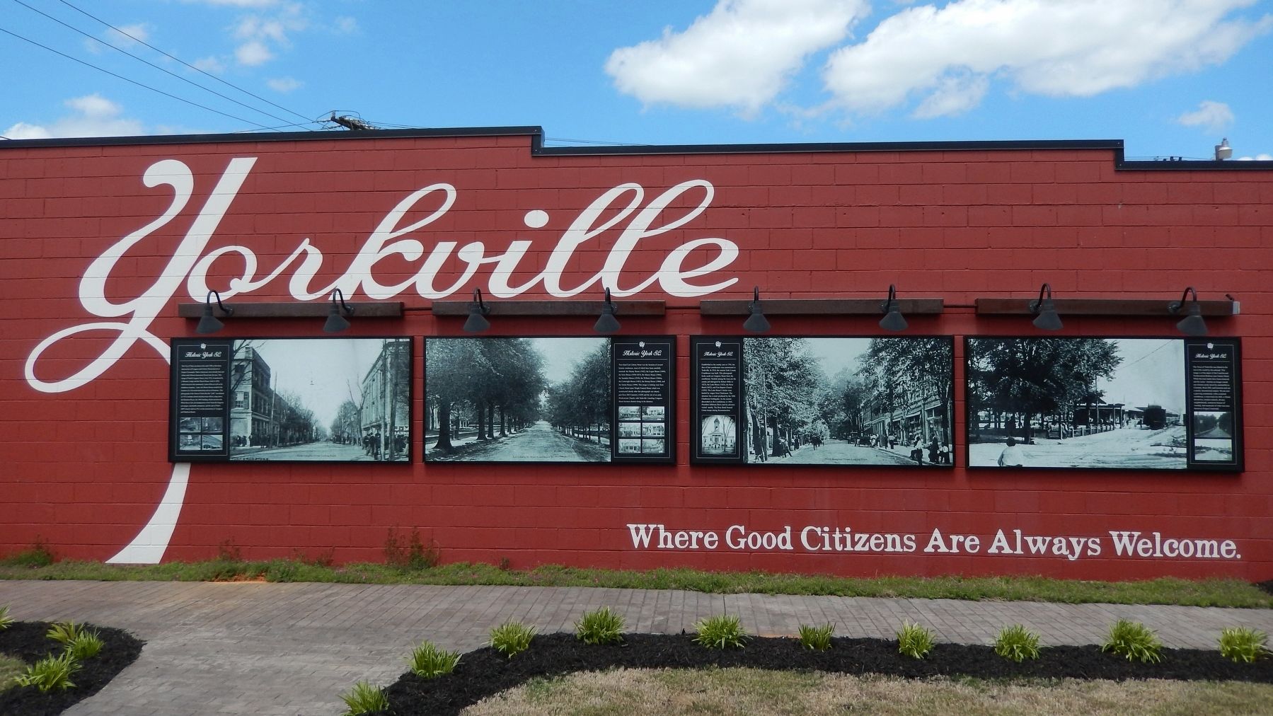
[panel 1]
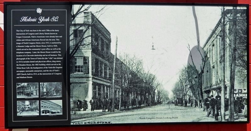
The City of York was born in the mid-1700s at the dusty intersection of Congress and Liberty Streets known as Fergus Crossroads. Native Americans were already here and whites and African-Americans flowed into the area. This image of North Congress Street, circa 1912, is anchored by a Masonic Lodge and the Moore House, built in 1820, which served as the community's post office as well as the telephone company. Later, the Moore House would be the location of a Chevrolet dealership and an oil business. This photograph of the Town of Yorkville (the "ville" was deleted in 1915) includes dental and physician offices, drug stores, the Brandon House, the 1882 building which served as the White Rose Café, the headquarters of the Yorkville Enquirer newspaper, mercantile enterprises, and the site of York's ARP Church, built in 1913, at the intersection of Congress and Madison Streets.
[panel 1 photo captions]
• North Congress Street, Looking North
• The O’Leary Block – circa 1912
• South Congress Street from Liberty Street – circa 1912
• Interior of Yorkville Hardware Co.’s Store – circa 1912
• The McNeal Block – circa 1912
[panel 2]
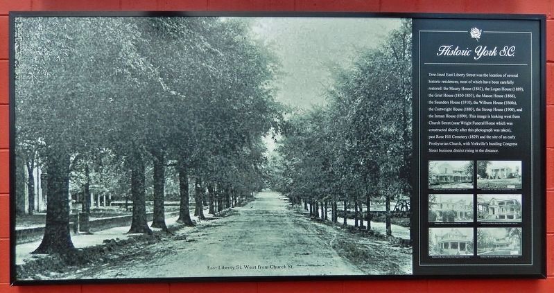
Tree-lined East Liberty Street was the location of several historic residences, most of which have been carefully restored: the Mauny House (1842), the Logan House (1889), the Grist House (1850-1853), the Mason House (1866), the Saunders House (1910), the Wilburn House (1860s), the Cartwright House (1883), the Stroup House (1900), and the Inman House (1890). This image is looking west from Church Street (near Wright Funeral Home which was constructed shortly after this photograph was taken), past Rose Hill Cemetery (1829) and the site of an early Presbyterian Church, with Yorkville's bustling Congress Street business district rising in the distance.
[panel 2 photo captions]
• East Liberty Street, West from Church Street
• Residence of Mr. Jno., R. Logan, East Liberty Street – circa 1912
• Residence of Mr. R.T. Allison, King’s Mountain Street – circa 1912
• Residence of Mrs. S.C. Ashe, East Liberty Street – circa 1912
• Residence of the Misses Quinn, King’s Mountain Street – circa 1912
• Residence of Mrs. Marie C. Glenn, North Congress Street – circa 1912
• Residence of Mr. Franck C. Riddle, North Congress Street – circa 1912
[panel 3]
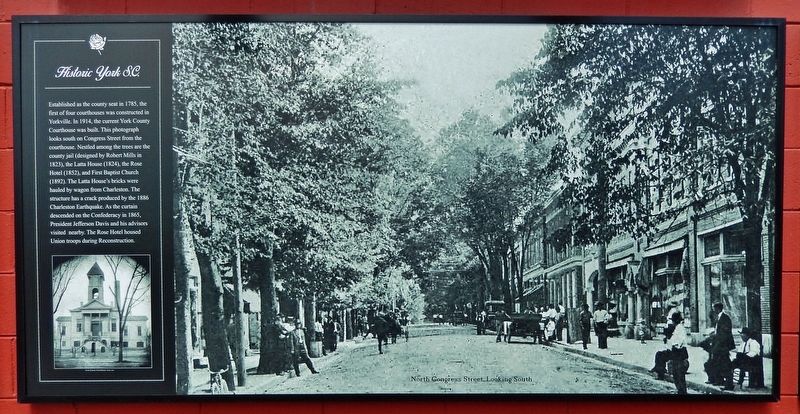
Established as the county seat in 1785, the first of four courthouses was constructed in Yorkville. In 1914, the current York County Courthouse was built. This photograph looks south on Congress Street from the courthouse. Nestled among the trees are the county jail (designed by Robert
Mills in 1823), the Latta House (1824), the Rose Hotel (1852), and First Baptist Church (1892). The Latta House's bricks were hauled by wagon from Charleston. The structure has a crack produced by the 1886 Charleston Earthquake. As the curtain descended on the Confederacy in 1865, President Jefferson Davis and his advisors visited nearby. The Rose Hotel housed Union troops during Reconstruction.
[panel 3 photo captions]
• North Congress Street, Looking South
• York County Courthouse – circa 1912
[panel 4]
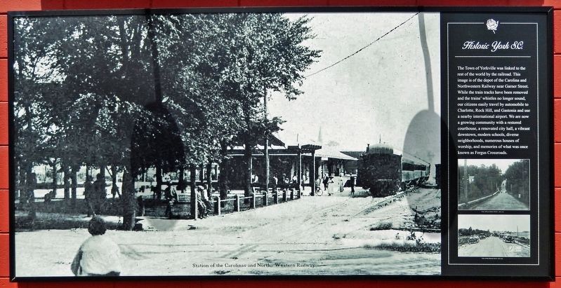
The Town of Yorkville was linked to the rest of the world by the railroad. This image is of the depot of the Carolina and Northwestern Railway near Garner Street. While the train tracks have been removed and the trains' whistles no longer sound, our citizens easily travel by automobile to Charlotte, Rock Hill, and Gastonia and use a nearby international airport. We are now a growing community with a restored courthouse, a renovated city hall, a vibrant downtown, modern schools, diverse neighborhoods, numerous houses of worship, and memories of what was once known as Fergus Crossroads.
[panel 4 photo captions]
• Station of the Carolinas and North Western Railway
• View of East Liberty Street – circa 1912
• View of the Chester Road – circa 1912
Topics. This historical marker is listed in these topic
lists: Architecture • Industry & Commerce • Railroads & Streetcars • War, US Civil.
Location. 34° 59.747′ N, 81° 14.348′ W. Marker is in York, South Carolina, in York County. Marker is on North Roosevelt Street (State Highway 307) just south of East Madison Street (State Highway 116), on the right when traveling north. This marker comprises 4 large panels mounted across the south side of the building at this address. Touch for map. Marker is at or near this postal address: 20 North Roosevelt Street, York SC 29745, United States of America. Touch for directions.
Other nearby markers. At least 8 other markers are within walking distance of this marker. Town of Yorkville / Town of York (about 500 feet away, measured in a direct line); York County Veterans Memorial (approx. 0.2 miles away); a different marker also named Historic York (approx. 0.2 miles away); Trinity M. E. Church, South (approx. 0.2 miles away); First Presbyterian Church (approx. 0.2 miles away); York County Courthouse (approx. 0.2 miles away); York County Courthouses (approx. ¼ mile away); David E. Finley Birthplace (approx. ¼ mile away). Touch for a list and map of all markers in York.
Also see . . .
1. History of York. Yorkville Historical Society website entry:
Excerpt:
By 1823 there were 451 people living in Yorkville—292 Whites and 159 Blacks (“negroes”). There were 80 houses in the town, 52 mechanics, eight lawyers, two physicians, and one clergyman. There were eight stores, five taverns, one male and one female academy, and a printing office. Yorkville was officially incorporated on December 7, 1841. W. I. Clawson was the first mayor, with Stanhope Sadler, F. M. Galbraith, T. H. Simril, and B. T. Wheeler as wardens. The population of the town at that time was about 800.(Submitted on December 15, 2023, by Cosmos Mariner of Cape Canaveral, Florida.)
2. Historic sites. York website entry (Submitted on February 17, 2024, by Larry Gertner of New York, New York.)
Credits. This page was last revised on February 17, 2024. It was originally submitted on December 14, 2023, by Cosmos Mariner of Cape Canaveral, Florida. This page has been viewed 133 times since then and 90 times this year. Photos: 1, 2, 3, 4, 5. submitted on December 14, 2023, by Cosmos Mariner of Cape Canaveral, Florida.
