Ponte de Lima, Viana do Castelo, Portugal — Southwestern Europe (Iberian Peninsula)
Capela das Pereiras
⎯⎯⎯
Pereiras Chapel
Photographed by Andrew Ruppenstein, September 4, 2023
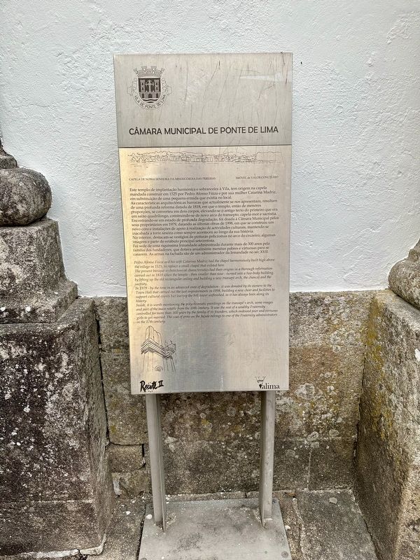
1. Capela de Nissan Senhora / Chapel of Our Lady Marker

Capela de Nossa Senhora da Misericórdia das Pereiras
Imóvel de Valor Concelhio
Este templo de implantação harmónica e sobranceira à Vila, tem origem na capela mandada construir em 1525 por Pedro Afonso Fiúza e por sua mulher Catarina Madriz, em substituição de uma pequena ermida que existia no local. As características arquitectónicas barrocas que actualmente se nos apresentam, resultam de uma profunda reforma datada de 1818, em que o templo, então de menores proporções, se converteu em dois corpos, elevando-se o antigo tecto do primeiro que era um salão quadrilongo, construindo-se de novo arco do transepto, capela-mor e sacristia. Encontrando-se em estado de profunda degradação, foi doada à Câmara Municipal pelos seus proprietários em 1979, datando as últimas obras de 1998, em que se construiu um novo coro e instalações de apoio à realização de actividades culturais, mantendo-se inacabada a torre sineira como sempre aconteceu ao longo da sua história. No interior, destacam-se vestígios de pinturas policromas no arco do cruzeiro, algumas imagens e parte do retábulo principal setecentista.
Foi sede
this page online
Property of Valor Municipality
Pedro Afonso Fiúza and his wife Catarina Madriz had the chapel harmoniously built high above the village in 1525, to replace a small chapel that existed here. The present baroque architectonical characteristics had their origins in a thorough reformation carried out in 1818 when the temple - then smaller than now - turned into a two-body building, by lifting up the old rectangular ceiling and building a new transept arch, the chancel and the sacristy.
In 1979 - by the time in an advanced state of degradation - it was donated by its owners to the Town Hall that carried out the last improvements in 1998, building a new choir and facilities to support cultural events but leaving the bell tower unfinished, as it has always been along its history.
Inside, it is worth mentioning the polychromatic paintings on the transept's arch,

Photographed by Andrew Ruppenstein, September 4, 2023
2. Capela das Pereiras / Pereiras Chapel Marker - wide view
Erected by Câmara Municipal de Ponte de Lima, Valima.
Topics. This historical marker is listed in this topic list: Religion & Religious Structures. A significant historical year for this entry is 1525.
Location. 41° 46.128′ N, 8° 34.942′ W. Marker is in Ponte de Lima, Viana do Castelo. It is on Largo Delfim Guimarães. Touch for map. Marker is at or near this postal address: Largo Delfim Guimarães 1, Ponte de Lima, Viana do Castelo 4990, Portugal. Touch for directions.

Regionally, it is in the North Atlantic Region, in Europe, in the European Union, in Atlantic Europe, on the Iberian Peninsula, in the Schengen Area, and in the Western World. Historically, it finds itself in what was once Portuguese colonies and also the Roman Empire.
Other nearby markers. At least 8 other markers are within walking distance

Photographed by Andrew Ruppenstein, September 4, 2023
3. Capela das Pereiras / Pereiras Chapel
Some steps are involved…
Also see . . . Capela das Pereiras (Visitar Portugal, in Portuguese).
Excerpt (in translation): The antiquity of Ponte de Lima makes it one of the main strategic locations in the territory. It is therefore the intersection of several paths, dating back to Roman times when the connection between Braga and Pontevedra was made, and later the main route of the Camino de Santiago.(Submitted on December 21, 2023.)
This route transformed Ponte de Lima into a place of shelter and various types of assistance to accommodate the pilgrims who were then heading to Compostela. This ended up seeing an increase in religious temples, as in the case of this chapel.
The Capela das Pereiras, so called today, originally the Capela de Santa Rita de Cássia, was built in the 16th century, next to the old wall, replacing an old hermitage that existed there.
It would undergo two campaigns of works, the first of which was a reconstruction due to the 1755 earthquake. The biggest intervention took place in 1818, changing the initial appearance, with the addition of a new apse to the nave and the sacristy, maintaining like that until now.
Credits. This page was last revised on December 21, 2023. It was originally submitted on December 21, 2023, by Andrew Ruppenstein of Lamorinda, California. This page has been viewed 154 times since then and 18 times this year. Photos: 1, 2, 3. submitted on December 21, 2023, by Andrew Ruppenstein of Lamorinda, California.
