Gloucester Point in Gloucester County, Virginia — The American South (Mid-Atlantic)
Port of Call
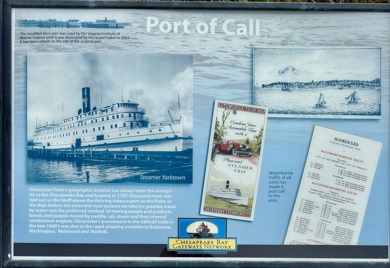
Gloucester Point's geographic location has always been the county's tie to the Chesapeake Bay and beyond. In 1707, Gloucestertown was laid out on the bluff above the thriving tobacco port on the Point. In the days before the extensive road systems we take for granted, travel by water was the preferred method of moving people and products. Goods and people moved by paddle, sail, steam and then internal combustion engines. Gloucester's prominence in the daffodil trade in the late 1800's was due to the rapid shipping available to Baltimore, Washington, Richmond and Norfolk.
(captions)
The modified ferry pier was used by the Virginia Institute of Marine Science until it was destroyed by Hurricane Isabel in 2003. It has been rebuilt on the site of the original pier.
Waterborne traffic of all sorts has made a port call in the area.
Erected by Chesapeake Bay Gateways Network.
Topics. This historical marker is listed in these topic lists: Industry & Commerce • Settlements & Settlers • Waterways & Vessels.
Location. 37° 14.812′ N, 76° 30.135′ W. Marker is in Gloucester Point, Virginia, in Gloucester County. Marker is at the intersection of Grate Road (Virginia Route 1208) and Franklin Road on Grate Road. The Marker is located at the northeastern area of the Gloucester Point Park parking lot, next to the dune cut through to the fishing pier. Touch for map. Marker is at or near this postal address: 1255 Grate Road, Gloucester Point VA 23062, United States of America. Touch for directions.
Other nearby markers. At least 8 other markers are within walking distance of this marker. Virginia Institute of Marine Science (about 500 feet away, measured in a direct line); Mother Nature Comes Calling (about 500 feet away); Harvesting Nature's Bounty (about 800 feet away); Virginia's First Shots in the Civil War (approx. 0.2 miles away); To Get to the Other Side (approx. 0.2 miles away); Freedom is Won (approx. 0.2 miles away); a different marker also named Port of Call (approx. 0.2 miles away); Gloucester Point (approx. 0.2 miles away). Touch for a list and map of all markers in Gloucester Point.
Also see . . . Gloucester Point, Virginia. Wikipedia entry (Submitted on March 21, 2024, by Larry Gertner of New York, New York.)
Credits. This page was last revised on March 21, 2024. It was originally submitted on January 25, 2024, by Brandon D Cross of Flagler Beach, Florida. This page has been viewed 51 times since then. Photos: 1, 2, 3, 4. submitted on January 25, 2024, by Brandon D Cross of Flagler Beach, Florida. • Andrew Ruppenstein was the editor who published this page.


