Neve Daniel , West Bank, Israel — West Asia (the Levant in the Middle East)
The Lion's Trail - Gush Etzion
2023
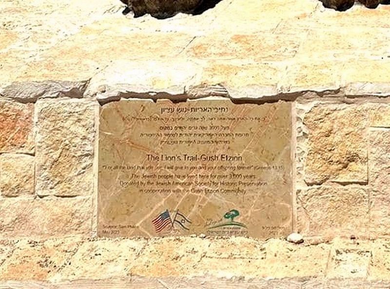
1. The Lion's Trail - Gush Etzion Marker

נתיב האריות - גוש עציון
Hebrew text not transcribed
The Lion's Trail - Gush Etzion
"For all the land that you see, I will give to you and your offspring forever." (Genesis 13:15)
The Jewish people have lived here for over 3,000 years.
Donated by the Jewish American Society for Historic Preservation in cooperation with the Gush Etzion Community.
Sculptor Sam Philipe May, 2023
Erected 2023 by Jewish American Society for Historic Preservation.
Topics and series. This historical marker is listed in this topic list: Settlements & Settlers. In addition, it is included in the Jewish American Society for Historic Preservation. series list.
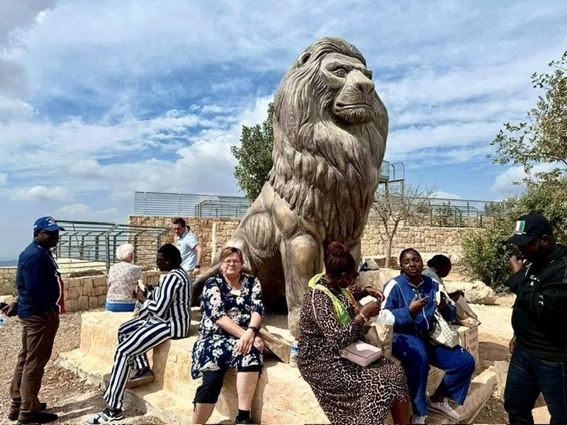
Location. 31° 40.97′ N, 35° 8.696′ E. Marker is in Neve Daniel, Judea and Samaria Area (West Bank). It can be reached from Sde Boaz Street. The Lion of Gush Etzion is built adjacent to the Mitzpor HaEleph, the View of a 1,000 meters, lookout build by the Jewish National Fund. The Lion of Gush Etzion
this page online

Regionally, it is in Asia, specifically in West Asia, in the Middle East, in The Levant, on the Red Sea, in a coastal Mediterranean country, and in the Western World. Historically, it finds itself in what was once the Byzantine Empire, the Ottoman Empire, a British Mandate, and the Roman Empire.
Other nearby markers. At least 8 other markers are within 13 kilometers of this marker, measured as the crow flies: Nativity Church (approx. 6.4 kilometers away in Palestinian Territories); The ancient aqueducts to Jerusalem (approx. 9.8 kilometers away in Jerusalem District); Arnona Neighborhood (approx. 10.2 kilometers away in Jerusalem District); Stephen Theodore Norman, 1918-1946. Last descendent of Theodor Herzl

2. The Lion's Trail - Gush Etzion Marker and Lion
More about this marker. The core group of the Gush Etzion Bloc includes four Jewish agricultural villages that were founded in 1943–1947, and destroyed by the Arab Legion before the outbreak of the 1948 Arab–Israeli War, in the Kfar Etzion massacre. The area was left outside of Israel with the 1949 armistice lines. These settlements were rebuilt after the 1967 Six-Day War, along with new communities that have expanded the area of the Etzion Bloc. As of 2011, Gush Etzion consisted of 22 settlements with a population of 70,000.
Controversially today, the area is claimed by both Israel and the Palestinian Authority.
Also see . . .
1. Gush Etzion. (Submitted on February 5, 2024, by Jerry Klinger of Boynton Beach, Florida.)
2. High Point of Israel.
Photographed by Jerry Klinger
3. The Lion's Trail - Gush Etzion Lion
The site was developed with the Jewish National Fund in conjunction with the Gush Etzion Regional Council and Neve Daniel. It is dedicated to the memory of Sam and Frieda Makovsky of Pueblo, Colorado, family of one of Neve Daniel's founders, Chaim Makovsky.(Submitted on February 5, 2024, by Jerry Klinger of Boynton Beach, Florida.)
It’s called Mitzpor HaElef. "Mitzpor" is a lookout and "Elef" is 1000. Our lookout is 1000 meters above sea level; it’s one of the highest points in the country and certainly the highest point from anywhere nearby.
3. Visiting the Way of the Patriachs in Gush Etzion.
Travel between Hebron and Jerusalem first became important on a mass scale during the time when the First and Second Holy Temples stood in Jerusalem. Three times a year, residents from all over Israel traveled to Jerusalem for the pilgrimage festivals, and the Way of the Patriarchs is believed to be the road used by residents who lived south of Jerusalem. The highlights of the Path of the Patriarchs today are a Roman milestone marker, a mikvah (ritual bath) and the Biyah Aqueduct.(Submitted on February 5, 2024, by Jerry Klinger of Boynton Beach, Florida.)
4. View from the Mitzpor HaEleph site. 15 year old Youtube video of the view from Mitzpor HaEleph before the construction of the Lookout by JNF. (Submitted on February 5, 2024, by Jerry Klinger of Boynton Beach, Florida.)
5. The Etzion Bloc.
In 1930, the site of the former Migald Eder was purchased by Shmuel Yosef Holtzman, who wanted to establish a Jewish community in between Bethlehem and Hebron. The word “holtz” in German literally means “wood,” which is translated into Hebrew as “etz,” so Holtzman named the community Kfar Etzion after his own name. Again, Arab riots, this time in 1936, demolished most of what Holtzman had built, and the violence forced the inhabitants out of the area. Jews finally did settle the area between 1943-1947, and established four small communities, which were all subsequently destroyed during Israel’s War of Independence.(Submitted on February 5, 2024, by Jerry Klinger of Boynton Beach, Florida.)
6. The Lion's Trail - Gush Etzion.
"Below the Mitzpor is an ancient path called Derech HaAvot, the Path of the Patriarchs. Abraham, Isaac, and Jacob traveled the path 3500-4000 years ago. The path was the main access between Hebron and Jerusalem. A 2,000-year-old Mikveh, a Jewish ritual bath, is nearby...(Submitted on May 3, 2024, by Jerry Klinger of Boynton Beach, Florida.)
...Six hundred years after the destruction of the Temple, the Muslims had conquered the Christians of Palestine. They built the Dome of the Rock above the very stone that Abraham had tied Isaac to as a sacrifice on the Temple Mount. The Dome of the Rock was built as a shrine for pilgrims, not a Mosque. It became a Mosque later. The Temple Mount, the entire “Holy Land”, has been a flashpoint between Muslims, Christians, and Jews ever since."
Credits. This page was last revised on May 3, 2024. It was originally submitted on February 4, 2024, by Jerry Klinger of Boynton Beach, Florida. This page has been viewed 510 times since then and 50 times this year. Photos: 1, 2. submitted on February 5, 2024, by Jerry Klinger of Boynton Beach, Florida. 3. submitted on February 4, 2024, by Jerry Klinger of Boynton Beach, Florida. • Andrew Ruppenstein was the editor who published this page.
