Coltons Point in St. Mary's County, Maryland — The American Northeast (Mid-Atlantic)
"…one of the pleasantest summer resorts on the Potomac"
Inscription.
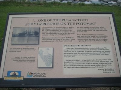
Tourism thrived on the island after Dr. Joseph McWilliams built a steamboat wharf in 1868. Dr. McWilliams enlarged his home to make room for a growing number of summer visitors from Baltimore and Washington. he also added cottages, a dining hall, and a bathhouse.
With the success of his resort, Dr. McWilliams subdivided the island into 34 sections of about seven lots each in 1883. A new brick hotel and more cottages soon followed. He did not, however, sell enough plots to make his subdivision profitable. The island was sold in default in 1896.
When the Butterfield family became the new owners of the island, they continued to welcome vacationers. They put three new cottages on the northeast end of the island, replacing the rundown McWilliams lodges.
A Visitor Praises the Island Resort
"…This is one of the pleasantest summer resorts on the Potomac. The fishing is better than lower down the river, the shooting good, fruit plentiful in its season, and Dr. McWilliams, his sons and daughters, the most agreeable and attentive of hosts. The accommodations, which are sufficient for about fifty guests, consist of a row of cottages, situated on a bank which slopes down to the river.
…And such a breakfast!…A large haul of taylor [bluefish] had been made the night before, and these delicious fish, done to a turn, grace the table. Then there were oysters, fried in a batter yet devoid of grease and retaining the full flavor of the bivalve, fresh-laid eggs, crisp bacon, muffins, rolls, corn bread, tea, coffee, chocolate and milk ad libitum [at one's pleasure]...." - "Cruise of the Blue Bird," St. Mary's Beacon, November 5, 1874
[photo of cottages] This photo shows the Butterfield cottages that once stood on the northeastern side of Blackistone Island.
[image of subdivision] In 1883, Dr. Joseph McWilliams subdivided Blackistone [St. Clement's] Island to sell off plots and make his island resort more profitable.
Erected by Chesapeake Bay Gateways Network, Maryland Department of Natural Resources.
Topics. This historical marker is listed in this topic list: Entertainment. A significant historical month for this entry is November 1634.
Location. Marker has been permanently removed. It was located near 38° 12.519′ N, 76° 44.549′ W. Marker was in Coltons Point, Maryland, in St. Mary's County. Marker could be reached from Point Breeze Road, 0.2 miles Colton Point Road (Route 242). Marker is on St. Clements Island which is only accessibly by boat. A ferry operates on weekends from the St. Clement's Island Museum on
Point Breeze Road. Touch for map. Marker was in this post office area: Coltons Point MD 20626, United States of America.
We have been informed that this sign or monument is no longer there and will not be replaced. This page is an archival view of what was.
Other nearby markers. At least 8 other markers are within walking distance of this location. St. Clement's Hundred (about 300 feet away, measured in a direct line); St. Clement's Island (about 500 feet away); Ancestral Garden (about 500 feet away); Freedom to Worship (about 600 feet away); Trade Expands (about 600 feet away); Blackistone Lighthouse (about 700 feet away); a different marker also named Blackistone Lighthouse (about 700 feet away); a different marker also named Blackistone Lighthouse (about 700 feet away). Touch for a list and map of all markers in Coltons Point.
Credits. This page was last revised on August 27, 2022. It was originally submitted on November 7, 2009, by F. Robby of Baltimore, Maryland. This page has been viewed 792 times since then and 7 times this year. Photos: 1, 2. submitted on November 7, 2009, by F. Robby of Baltimore, Maryland.

