Spring Township near Elliottsburg in Perry County, Pennsylvania — The American Northeast (Mid-Atlantic)
Growth of Agriculture, Commerce and Industry Before the Civil War

Photographed By Devry Becker Jones (CC0), February 23, 2024
1. Growth of Agriculture, Commerce and Industry Before the Civil War Marker
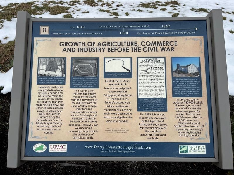
ca. 1842: African American settlement near Millerstown.
1850: Fugitive Slave Act enacted; Compromise of 1850.
1852: First fair by the Agricultural Society of Perry County
Relatively small-scale iron production began by 1808, after iron ore was discovered in the county. By the 1830s, the county's foundries made side hill plows and other popular patented plows. Constructed in 1835, the Caroline Furnace along the Pennsylvania Canal in Baileysburg is the only remaining cold blast furnace stack in the county.
The county's iron industry had largely waned by the 1850s with the movement of the industry from the Juniata Valley to large industrial and transportation centers such as Pittsburgh and Harrisburg. Only the Duncannon Iron Works expanded. However, iron was becoming increasingly important in the production of agricultural goods.
By 1811, Peter Moses operated his tilt hammer and edge tool factory south of Bridgeport, along Route 74. Included in the factory's output were sickles, scythes and reaping hooks. Reaping hooks were designed to both cut and gather the grain into bundles.
The 1852 Fair at New Bloomfield, sponsored by the Agricultural Society of Perry County, was the first display of then-modern agricultural tools and methods.
In 1840, the county produced 720,000 bushels of wheat, rye, corn and oats, of which only the wheat was grown for market. The county's 3,600 farmers relied on 4,000 horses and maintained about 50,000 other livestock, all supporting the county's industries, including thriving tanneries.
[Captions:]
The Caroline Furnace viewed from the east, with the Pennsylvania Railroad tracks in the foreground, ca. 1880.
Detail of door of a Juniata Furnace stove showing the panel design and riveted hinges. The Juniata Furnace operated from 1808 to about 1850, near Little Buffalo State Park.
A typical, early reaping hook from the Blain area.
Elias Widel established the Clinton Foundry by 1839 when his advertisement for plows appeared in the Perry County Democrat. Later, Samuel Liggett took over this foundry located south of Ickesburg.
The Black-Achenbach barn in Raccoon Valley was constructed about 1858 as part of the Agricultural Reform Movement whereby farmsteads were re-built for greater ease in the farmer's work. This "triple decker" barn allowed grain to be directly deposited into the granary below.
Erected 2020 by UPMC; Historical Society of Perry County. (Marker Number 8.)
Topics and series. This historical marker is listed in these topic lists: African Americans

Photographed By Devry Becker Jones (CC0), February 23, 2024
2. Growth of Agriculture, Commerce and Industry Before the Civil War Marker
Location. 40° 23.087′ N, 77° 17.854′ W. Marker is near Elliottsburg, Pennsylvania, in Perry County. It is in Spring Township. Marker can be reached from Shermans Valley Road (Pennsylvania Route 274) 0.4 miles east of Veterans Way (Pennsylvania Route 74), on the right when traveling west. Touch for map. Marker is at or near this postal address: 2471 Shermans Valley Rd, Elliottsburg PA 17024, United States of America. Touch for directions.
Other nearby markers. At least 8 other markers are within walking distance of this marker. Early Schools, Academies and Religious Institutions (here, next to this marker); The Perry County Home Front During World War II (here, next to this marker); Forces of Change 1945-2020 (here, next to this marker); Pre-Civil War Transportation Development (here, next to this marker); Most Visible Changes 1945-2020 (here, next to this marker); Building on the Past as We March into the Future (a few steps from this marker); Post-Civil War Transformation (a few steps from this marker); The Greatest Generation Goes to War (a few steps from this marker). Touch for a list and map of all markers in Elliottsburg.
Credits. This page was last revised on February 28, 2024. It was originally submitted on February 28, 2024, by Devry Becker Jones of Washington, District of Columbia. This page has been viewed 40 times since then. Photos: 1, 2. submitted on February 28, 2024, by Devry Becker Jones of Washington, District of Columbia.