Stuyvesant Falls in Columbia County, New York — The American Northeast (Mid-Atlantic)
Passenger and Freight Depots
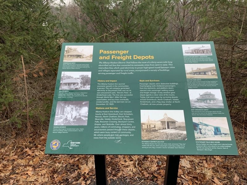
The Albany-Hudson Electric Trail follows the route of a thirty-seven-mile-long electrified rail line that connected its namesake cities from 1900 to 1929. This interurban line, which used electricity to power high-speed travel between cities and villages separated by rural areas, incorporated a variety of buildings serving passenger and freight traffic.
History and Impact
The Albany-Hudson line spurred economic growth in the communities it served. The rail company generated electricity at Stuyvesant Falls and ran its own amusement park, "Electric Park," at Kinderhook Lake. The line was successful through World War I. After the war, automobiles and bus lines eventually eroded profits, and the last train ran on December 22, 1929.
Stations and Service
Albany Hudson line trolley cars stopped hourly at East Greenbush, East Schodack, Nassau, North Chatham, Electric Park, Niverville, Valatie, Kinderhook, Stuyvesant Falls, Rossman Crossing, Stockport Centre, Empire, and Stottville. Over almost thirty years, millions of commuters, shoppers, and excursionists passed through these depots. which were busy centers of community life where people got mail, packages, and news from the outside world.
Style and Survivors
Passenger depots were distinctive buildings. Overhanging roofs sheltered passengers from the elements, and platform doors opened onto passenger waiting rooms and freight storage. A bay window gave depot agents a clear view of the tracks. Today, trail users pass by surviving depots at East Greenbush, North Chatham, Valatie, Kinderhook, and a flag-stop shelter at North Chatham, all now private property.
(photos counterclockwise from top left)
KINDERHOOK DEPOT
But in 1900 classic passenger depot design was also used of Nassau. Depots were gateways to the outside world for communities along the line. Source: Nassau Village Historian.
VALATIE DEPOT
This 1905 depot was built to replace a dilapidated earlier built freight building. This design, using imitation stone blocks, was copied for the Stottville depot. Source: Lee Sharp.
NASSAU INTERIOR
Nassau depot agents handled ticket sales, freight, mail, and railway safety communications. Source: Nassau Village Historian.
SCHODACK CENTRE FLAG STOP
The Albany-Hudson line had over thirty small unmanned "fag stop" shelters like this one where passengers could stop a trolley car by waving an arm, flag, or lantern. Source: Schodack Town Historian.
STUYVESANT FALLS MILK HOUSE
Albany-Hudson line daily freight trains collected locally produced milk in cans stored in ice-cooled buildings like this one along the rail line Source: Town of Stockport/Alice Engel.
EAST GREENBUSH DEPOT
This unusual two-story passenger depot was the only one of its kind on the Albany-Hudson trolley line. Source: East Greenbush Historian.
ELECTRIC PARK DEPOT
This long narrow depot housed six ticket windows to handle sudden throngs of eager arrivals at Electric Park, the Albany-Hudson line's own amusement park on Kinderhook Lake at Niverville. Source"Nassau Village Historian.
NORTH CHATHAM DEPOT/SUBSTATION
Of the three brick electrical substations providing power for the rail line, this is the only survivor and the only one that doubled as a passenger depot. Source: Nassau Village Historian.
Erected by New York State, Empire State Trail.
Topics. This historical marker is listed in these topic lists: Parks & Recreational Areas • Railroads & Streetcars. A significant historical date for this entry is December 22, 1929.
Location. 42° 21.596′ N, 73° 43.911′ W. Marker is in Stuyvesant Falls, New York, in Columbia County. Marker can be reached from County Route 25A, half a mile north of New Road (County Route 25A). Touch for map. Marker is in this post office area: Kinderhook NY 12106, United States of America. Touch for directions.
Other nearby markers. At least 8 other markers are within 2 miles of this marker, measured as the crow flies. The Empire State Trail (approx. 0.2 miles away); Stuyvesant Falls Overlook Park (approx. 0.2 miles away); Kinderhook Creek (approx. 0.2 miles away); Stuyvesant Falls (approx. ¼ mile away); Stockport-Stuyvesant Line (approx. half a mile away); Farmhands and Fishing (approx. 1½ miles away); An Agrarian Lifestyle… (approx. 1½ miles away); Farm Operations (approx. 1½ miles away). Touch for a list and map of all markers in Stuyvesant Falls.
Credits. This page was last revised on March 6, 2024. It was originally submitted on March 5, 2024, by Steve Stoessel of Niskayuna, New York. This page has been viewed 41 times since then. Photos: 1, 2. submitted on March 5, 2024, by Steve Stoessel of Niskayuna, New York. • Andrew Ruppenstein was the editor who published this page.

