Stuyvesant Falls in Columbia County, New York — The American Northeast (Mid-Atlantic)
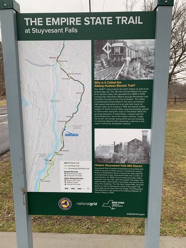
The Empire State Trail
At Stuyvesant Falls
Why is It Called the Albany-Hudson Electric Trail?
The "AHET" name honors the trail's history as well as its present day use. The 36-mile rail-trail follows the route of an electric trolley that operated from 1899 to 1929 running from downtown Albany through Rensselaer and Columbia Counties to the City of Hudson. The trolley revolutionized transportation in the area, providing a high-speed alternative to horse and mule travel on muddy roads. At its heyday in 1915, the electric trolley logged 1.4 million annual riders spurring dramatic growth in communities along the route. In December 1929, the growing popularity of automobiles, coupled with the Great Depression, led to the trolley's demise. Today. the former rail corridor along which you are traveling is owned by National Grid, providing a vital link in the region's electricity distribution network.
Historic Stuyvesant Falls Mill District
Stuyvesant Falls is typical of industrial communities that arose at sources of water power in nineteenth century America. Established along a natural two-step waterfall on Kinderhook Creek, Stuyvesant Falls was a center of rural industry. An 1836 account noted two large cotton factories, two saw mills, grist mill, plaster mill, paper mill satinet (cotton satin) factory, two stores, two taverns and forty-nine dwellings. The Van Alen Cotton Mills, pictured above, as well as spectacular views of the upper and lower falls can be seen from the bridge. The Stuyvesant Falls Mill District was listed on the National Register of Historic Places in 1976.
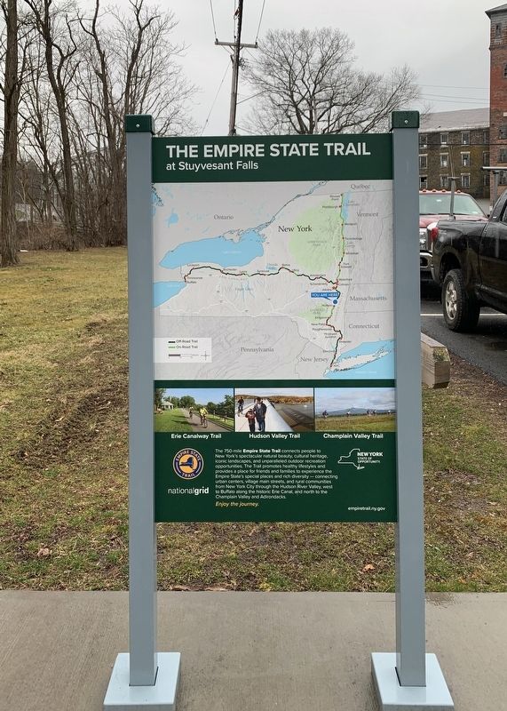
Side 2:
The 750-mile Empire State Trail connects New York's spectacular natural beauty cultural heritage, iconic landscapes and unparalleled outdoor recreational opportunities. The Trail promotes healthy styles and provides a place for friends and families to experience the Empire State's special places and rich diversity - connecting urban centers, village main streets and rural communities from New York City through the Hudson River Valley, west to Buffalo along the historic Erie Canal, and north to the Champlain Valley and Adirondacks. Enjoy the journey.
empiretrail.ny.gov
Erected by New York State, National Grid.
Topics. This historical marker is listed in these topic lists: Industry & Commerce • Parks & Recreational Areas • Railroads & Streetcars. A significant historical month for this entry is December 1929.
Location. 42° 21.485′ N, 73° 44.007′ W. Marker is in Stuyvesant Falls, New York, in Columbia County. Marker is at the intersection of New Street (County Route 25A) and Woods Lane, on the right when traveling north on New Street. Touch for map. Marker is at or near this postal address: 46 New Street, Kinderhook NY 12106, United States of America. Touch for directions.
Other nearby markers. At least 8 other markers are within 2 miles of this marker, measured as the crow flies. Stuyvesant Falls Overlook Park (a few steps from this marker); Kinderhook Creek (within shouting distance of this marker); Stuyvesant Falls (about 700 feet away, measured in a direct line); Passenger and Freight Depots (approx. 0.2 miles away); Stockport-Stuyvesant Line (approx. 0.4 miles away); Farmhands and Fishing (approx. 1.7 miles away); An Agrarian Lifestyle… (approx. 1.7 miles away); Farm Operations (approx. 1.7 miles away). Touch for a list and map of all markers in Stuyvesant Falls.
Also see . . .
1. Albany Hudson Electric Trail. (Submitted on March 5, 2024, by Steve Stoessel of Niskayuna, New York.)
2. Empire State Trail. (Submitted on March 5, 2024, by Steve Stoessel of Niskayuna, New York.)
Credits. This page was last revised on March 6, 2024. It was originally submitted on March 4, 2024, by Steve Stoessel of Niskayuna, New York. This page has been viewed 38 times since then. Last updated on March 6, 2024, by Steve Stoessel of Niskayuna, New York. Photos: 1, 2, 3. submitted on March 4, 2024, by Steve Stoessel of Niskayuna, New York. • Devry Becker Jones was the editor who published this page.


