Lincoln Park in Chicago in Cook County, Illinois — The American Midwest (Great Lakes)
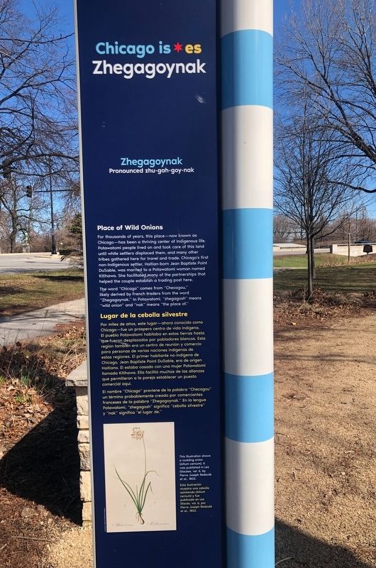
Chicago is Zhegagoynak
Pronounced zhu-gah-goy-nak
Place of Wild Onions
For thousands of years, this place—now known as Chicago—has been a thriving center of Indigenous life. Potawatomi people lived on and took care of this land until white settlers displaced them, and many other tribes gathered here for travel and trade. Chicago's first non-Indigenous settler, Haitian-born Jean Baptiste Point DuSable, was married to a Potawatomi woman named Kitihawa. She facilitated many of the partnerships that helped the couple establish a trading post here.
The word "Chicago" comes from "Checagou," likely derived by French traders from the word "Zhegagoynak." In Potawatomi, "zhegagosh" means "wild onion" and "nak" means "the place of."
Lugar de la cebolla silvestre
Por miles de años, este lugar—ahora conocido como Chicago—fue un próspero centro de vida indígena. El pueblo Potawatomi habitaba en estas tierras hasta que fueron desplazados por pobladores blancos. Esta región también era un centro de reunión y comercio para personas de varias naciones indígenas de estas regiones. El primer habitante no-indígena de Chicago, Jean Baptiste Point DuSable, era de origen Haitiana. Él estaba casado con una mujer Potawatomi Ilamada Kitihawa. Ella facilitó muchas de las alianzas que permitieron a la pareja establecer un puesto comercial aquí.
El nombre "Chicago" proviene de la palabra "Checagou" un término probablemente creado por comerciantes franceses de la palabra "Zhegagoynak." En la lengua Potawatomi, "zhegagosh" significa "cebolla silvestre" y "nak" significa "el lugar de."
[Caption to the right of the photo:]
This illustration shows a nodding onion (Allium cernum). It was published in Les liliacés, vol. 6, by Pierre Joseph Redouté et al., 1802.
Esta ilustración muestra una cebolla asintiendo (Allium cernum) y fue publicada en Les liliacés, vol. 6, by Pierre Joseph Redouté et al., 1802.
[Rear side text:]
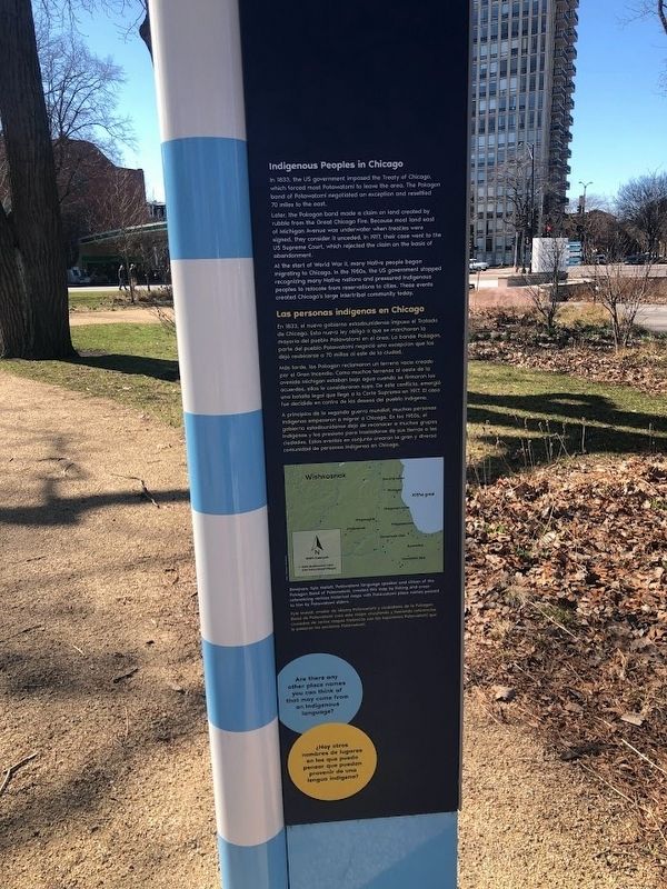
Indigenous Peoples in Chicago
In 1833, the US government imposed the Treaty of Chicago, which forced most Potawatomi to leave the area. The Pokagon band of Potawatomi negotiated an exception and resettled 70 miles to the east.
Later, the Pokagon band made a claim on land created by rubble from the Great Chicago Fire. Because most land east of Michigan Avenue was underwater when treaties were signed, they consider it unceded. In 1917, their case went to the US Supreme Court, which rejected the claim on the basis of abandonment.
At the start of World War II, many Native people began migrating to Chicago. In the 1950s, the US government stopped recognizing many Native nations and pressured Indigenous peoples to relocate from reservations to cities. These events created Chicago's large intertribal community today.
Las personas indígenas en Chicago
En 1833, el nuevo gobierno estadounidense impuso el Tratado de Chicago. Esta nueva ley obligó a que se marcharan la mayoría del pueblo Potawatomi en el área. La banda Pokagon, parte del pueblo Potawatomi negocio una excepción que los dejó reubicarse a 70 millas al este de la ciudad.
Más tarde, los Pokagon reclamaron un terreno vacío creado por el Gran Incendio. Como muchos terrenos al oeste de la avenida Michigan estaban bajo agua cuando se firmaron los acuerdos, ellos lo consideraron suyo. De este conflicto, emergio una batalla legal que llegó a la Corte Suprema en 1917. El caso fue decidido en contra de los deseos del pueblo indigena.
A principios de la segunda guerra mundial, muchas personas Indigenas empezaron a migrar a Chicago. En los 1950s, el gobierno estadounidense dejo de reconocer a muchos grupos Indigenas y los presiono para trasladarse de sus tierras a las ciudades. Estos eventos en conjunto crearon la gran y diversa comunidad de personas Indigenas en Chicago.
[Text below the map, which depicts Potawatomi villages in what is now the Chicago area:]
Bmejwen, Kyle Malott, Potawatomi language
speaker and citizen of the Pokagon Band of Potawatomi, created this map by linking and cross-referencing various historical maps with Potawatomi place names passed to him by Potawatomi elders.
Kyle Malott, orador de idioma Potawatomi y ciudadano de la Pokagon Band de Potawatomi creó este mapa vinculando y haciendo referencias cruzadas de varios mapas históricos con los topónimos Potawatomi que le pasaron los ancianos Potawatomi.
Erected 2021 by Chicago History Museum.
Topics. This historical marker is listed in these topic lists: Native Americans • Settlements & Settlers. A significant historical year for this entry is 1802.
Location. 41° 54.783′ N, 87° 37.914′ W. Marker is in Chicago, Illinois, in Cook County. It is in Lincoln Park. Marker is on West La Salle Drive (Illinois Route 64). The marker is on the Jaffee History Trail on the grounds of the Chicago History Museum. It is the second marker if walking from the north, about 40 yards from the trail's entrance (which is near the Clark and La Salle intersection). Touch for map. Marker is at or near this postal address: 1601 North Clark Street, Chicago IL 60614, United States of America. Touch for directions.
Other nearby markers. At least 8 other markers are within walking distance of this marker. Couch Tomb (a few steps from this marker); The Richard M. and Shirley H. Jaffee History Trail (within shouting distance of this marker); Chicago is Resilient
(within shouting distance of this marker); Chicago is Curious (within shouting distance of this marker); a different marker also named Couch Tomb (within shouting distance of this marker); Chicago is Complex (within shouting distance of this marker); Chicago is Community (about 400 feet away, measured in a direct line); Potter's Field (about 500 feet away). Touch for a list and map of all markers in Chicago.
Credits. This page was last revised on March 9, 2024. It was originally submitted on March 7, 2024, by Sean Flynn of Oak Park, Illinois. This page has been viewed 41 times since then. Photos: 1, 2. submitted on March 7, 2024, by Sean Flynn of Oak Park, Illinois. 3. submitted on March 8, 2024, by Sean Flynn of Oak Park, Illinois. 4. submitted on March 7, 2024, by Sean Flynn of Oak Park, Illinois.


