Devils Lake in Ramsey County, North Dakota — The American Midwest (Upper Plains)
The Origin of Devils Lake
65 million years in the making
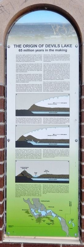
Devils Lake is rightly considered to be largely a product of glaciation, but the geologic events that led to its origin began long before the first glaciers came to North Dakota. An intricate series of events, beginning about 65 million years ago, eventually culminated in the formation of the lowland that is now flooded by Devils Lake.
Before it was glaciated, the landscape in the Devils Lake area, along with much of the rest of North Dakota, was quite different than it is today. Erosion during the long Tertiary Period, which began about 65 million years ago, shaped the gray shale surface of eastern North Dakota into a gently rolling plain that was somewhat less rugged than today's lake-dotted prairie.
North Dakota's climate gradually cooled during Tertiary time, falling from tropical levels at the start, to slightly cooler than they are today by the time the Tertiary Period ended. The Tertiary was followed by the Pleistocene Epoch, or "Ice Age", a time of much colder climate marked by episodes of glaciation interspersed with times of warmth, similar to our modern climate.
When the Ice Age began, about 2.6 million years ago, all of North Dakota was drained by an extensive river system that flowed northward to Hudson Bay. Two rivers dominated the Devils Lake region at that time. One flowed northwestward beneath the area that Devils Lake floods today and joined another, much larger river, somewhere near Churchs Ferry. The larger river was the northeastward, downstream extension of the combined preglacial Knife and Cannonball rivers, and it drained about half of North Dakota. The Knife/Cannonball River continued northward past Churchs Ferry, entering Canada a few miles east of the Turtle Mountains.
North Dakota was glaciated multiple times during the Ice Age as ice sheets that formed near Hudson Bay grew and shrank in response to alternating periods of cold and warmth. Each time the glaciers advanced from the north, they blocked the routes to Hudson Bay and forced the regional drainage southeastward along the edge of the ice sheet. Glacial meltwater that spilled into the old, preglacial river valleys filled them with layers of sand and gravel as much as 300 feet thick in places. In eastern North Dakota, these sands and gravels were later overridden by other glaciers and deeply buried beneath a thick covering of impermeable glacial sediment. Today some of the larger sand and gravel deposits are important aquifers.
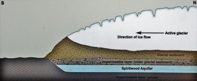
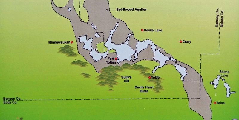
One of the largest aquifers in North Dakota is the Spiritwood Aquifer, a several-hundred-mile-long body of buried sand and gravel that occupies the old, preglacial Knife/Cannonball River valley and several tributaries. Like the ancestral river, the Spiritwood Aquifer passes beneath the area now containing the chain of bays that comprise Devils Lake. It is no coincidence, because it is the aquifer that is chiefly responsible for the lake's origin.
The events preceding the last major southward ice advance of the Pleistocene, the Late Wisconsinan glaciation, set the stage for the eventual formation of Devils Lake. When the Late Wisconsinan glacier flowed into the Devils Lake area about 12,000 years ago, the land was already covered by a thick layer of sediment from earlier glaciations that lay on top of shale of the Cretaceous-age Pierre Formation. The Late Wisconsinan glacier probably flowed over a tundra landscape, a region of permafrost where the ground was frozen to a depth of tens, possibly hundreds of feet.
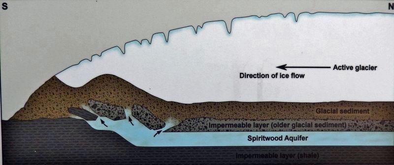
As the glacier advanced southward over what are today Ramsey, Nelson, and Benson counties, it overrode the Spiritwood Aquifer. The aquifer was saturated with groundwater, which had become trapped, a result of being confined between the impermeable, underlying shale, and the thick, equally impermeable covering of glacial sediment and frozen ground. The tremendous weight of the advancing glacier caused the water pressure in the materials beneath and ahead of the glacier to rise until it reached a point where something had to yield. Because the path of least resistance was upward, it was the materials above the pressurized groundwater that eventually gave way and were thrust up, in places along with blocks of shale bedrock, into the path of the advancing glacier, which shoved them a short distance to the south.
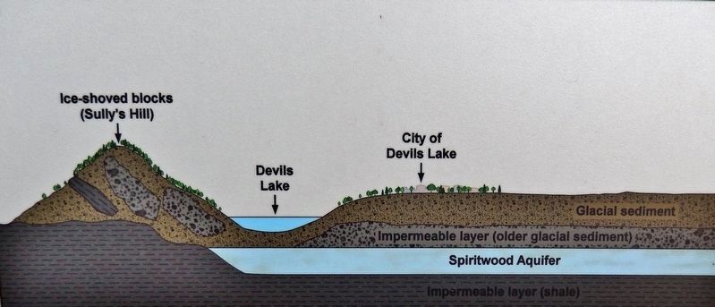
The ice thrusting in the Devils Lake area resulted in a now-flooded, lowland depression and a range of hills consisting of stacked-up slabs of glacial sediment and preglacial shale bedrock. The highest elevations, and the most rugged topography in this range of hills are at Sully's Hill. Here, slabs of shale, interbedded with glacial sediment, are visible in several places. Directly to the north of the ice-thrust hills is the elongate, east-west source depression — in reality a string of poorly connected depressions — that are today flooded by the several bays of Devils Lake and Stump Lake.
During the thrusting event, the high pressures in the groundwater were released as huge volumes of sediment-laden groundwater gushed to the surface. Some escaped through vertical cracks in the glacier, erupting onto the ice like a watery volcano and depositing its load of sediment, mostly sand and gravel, as a cone-shaped hill. Devils Heart Butte, near Tokio in Benson County, may have formed in this way.
Topics. This historical marker is listed in this topic list: Natural Features.
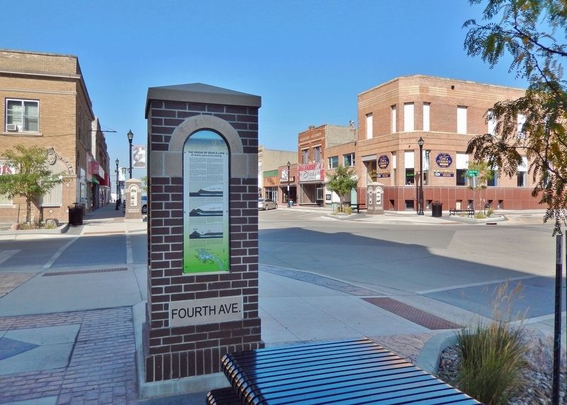
Location. 48° 6.701′ N, 98° 51.614′ W. Marker is in Devils Lake, North Dakota, in Ramsey County. Marker is at the intersection of 4th Street Northeast and 4th Avenue Northeast, on the left when traveling west on 4th Street Northeast. The marker is located on the sidewalk at the southeast corner of the intersection, facing east. Touch for map. Marker is at or near this postal address: 402 4th Street Northeast, Devils Lake ND 58301, United States of America. Touch for directions.
Other nearby markers. At least 8 other markers are within walking distance of this marker. Bangs-Wineman Block (here, next to this marker); History of Devils Lake (a few steps from this marker); The Lake “Mníwakháŋ” (a few steps from this marker); Historic Devils Lake Commercial District (within shouting distance of this marker); Devils Lake Flood Management (within shouting distance of this marker); Devils Lake State Bank (within shouting distance of this marker); Antiques Store (within shouting distance of this marker); Shannon Building (within shouting distance of this marker). Touch for a list and map of all markers in Devils Lake.
Also see . . . Geology of the Devils Lake Basin (U.S.G.S). Excerpt:
Geologic features of the Devils Lake Basin primarily are a result of the depositional and erosional effects of continental glaciation, which ended about 10,000 years ago (Aronow, 1957; Bluemle, 1981). In some areas of the Devils Lake Basin, the glaciers gouged out large depression in the shale. In other areas, such as at Devils Lake, large blocks of shale were detached from their original site of deposition and redeposited in the glacial drift. As the glaciers advanced, they overrode the saturated sediments that had filled the Cannonball River Valley. The weight of the advancing glaciers increased ground-water pressure in the Cannonball River Valley sediments, the overlying material was lifted up into the advancing glacier, and an excavated depression was created. The glaciers then pushed or thrust the material a few miles to the south-southwest. The excavated depression now is occupied by Devils Lake, and the material thrust to the south-southwest is known as Sully's Hill (Bluemle, 1981; J.P. Bluemle, written commun., 1991).(Submitted on March 12, 2024, by Cosmos Mariner of Cape Canaveral, Florida.)
Credits. This page was last revised on March 12, 2024. It was originally submitted on March 11, 2024, by Cosmos Mariner of Cape Canaveral, Florida. This page has been viewed 40 times since then. Photos: 1, 2, 3, 4, 5, 6. submitted on March 12, 2024, by Cosmos Mariner of Cape Canaveral, Florida.
