Saint Anthony Main in Minneapolis in Hennepin County, Minnesota — The American Midwest (Upper Plains)
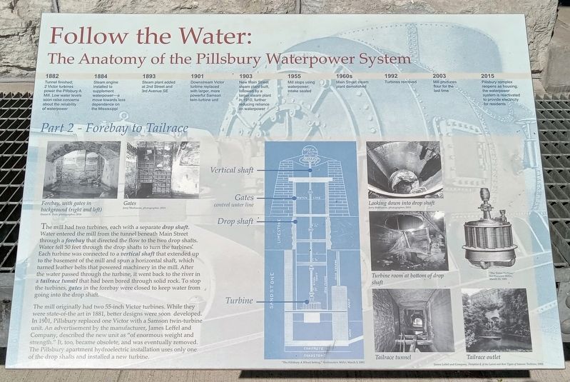
Follow the Water: Part 2 - Forebay to Tailrace
The Anatomy of the Pillsbury Waterpower System
Inscription.
1882
Tunnel finished; 2 Victor turbines power the Pillsbury A Mill. Low water levels soon raise concerns about the reliability of waterpower
1884
Steam engine installed to supplement waterpower—a move towards less dependence on the Mississippi
1893
Steam plant added at 2nd Street and 3rd Avenue SE
1901
Downstream Victor turbine replaced with larger, more powerful Samson twin-turbine unit
1903
New Main Street steam plant built, followed by a larger steam plant in 1910, further reducing reliance on waterpower
1955
Mill stops using waterpower; intake sealed
1960s
Main Street steam plant demolished
1992
Turbines removed
2003
Mill produces flour for the last time
2015
Pillsbury complex reopens as housing; the waterpower system is reactivated to provide electricity for residents
Forebay, with gates in background (right and left)
Daniel R. Pratt, photographer, 2014
Gates
Jerry Mathiason, photographer, 2015
The mill had two turbines, each with a separate drop shaft. Water entered the mill from the tunnel beneath Main Street through a forebay that directed the flow to the two drop shafts. Water fell 50 feet through the drop shafts to turn the turbines. Each turbine was connected to a vertical shaft that extended up to the basement of the mill and spun a horizontal shaft, which turned leather belts that powered machinery in the mill. After the water passed through the turbine, it went back to the river in a tailrace tunnel that had been bored through solid rock. To stop the turbines, gates in the forebay were closed to keep water from going into the drop shaft.
The mill originally had two 55-inch Victor turbines. While they were state-of-the-art in 1881, better designs were soon developed. In 1901, Pillsbury replaced one Victor with a Samson twin-turbine unit. An advertisement by the manufacturer, James Leffel and Company, described the new unit as "of enormous weight and strength." It, too, became obsolete, and was eventually removed. The Pillsbury apartment hydroelectric installation uses only one of the drop shafts and installed a new turbine.
"The Pillsbury A Wheel Setting," Northwestern Miller, March 3, 1992
Looking down into drop shaft
Jerry Mathiason, photographer, 2015
Turbine
room at bottom of drop shaft
"The Victor Turbine," Northwestern Miller, March 25, 1881
Tailrace tunnel
Tailrace outlet
James Leffel and Company, Pamphlet K of the Latest and Best Types of Samson Turbines, 1902
Topics. This historical marker is listed in these topic lists: Industry & Commerce • Waterways & Vessels. A significant historical year for this entry is 1882.
Location. 44° 59.026′ N, 93° 15.201′ W. Marker is in Minneapolis, Minnesota, in Hennepin County. It is in Saint Anthony Main. Marker is at the intersection of SE Main Street and SE 3rd Avenue, on the right when traveling west on SE Main Street. Touch for map. Marker is at or near this postal address: 301 SE Main Street, Minneapolis MN 55414, United States of America. Touch for directions.
Other nearby markers. At least 8 other markers are within walking distance of this marker. Franklin Steele (a few steps from this marker); Pillsbury A Mill (within shouting distance of this marker); Power on the East Side (about 300 feet away, measured in a direct line); Harnessing Waterpower (about 400 feet away); Electricity and Minneapolis (about 400 feet away); Follow the Water: Part 1 - Intake and Tunnel (about 400 feet away); The Falls That Built the City (about 400 feet away); a different marker also named The Pillsbury A Mill (about 400 feet away). Touch for a list and map of all markers in Minneapolis.
Credits. This page was last revised on March 23, 2024. It was originally submitted on March 23, 2024, by McGhiever of Minneapolis, Minnesota. This page has been viewed 42 times since then. Photos: 1, 2, 3, 4. submitted on March 23, 2024, by McGhiever of Minneapolis, Minnesota.


