Near Oktaha in Muskogee County, Oklahoma — The American South (West South Central)
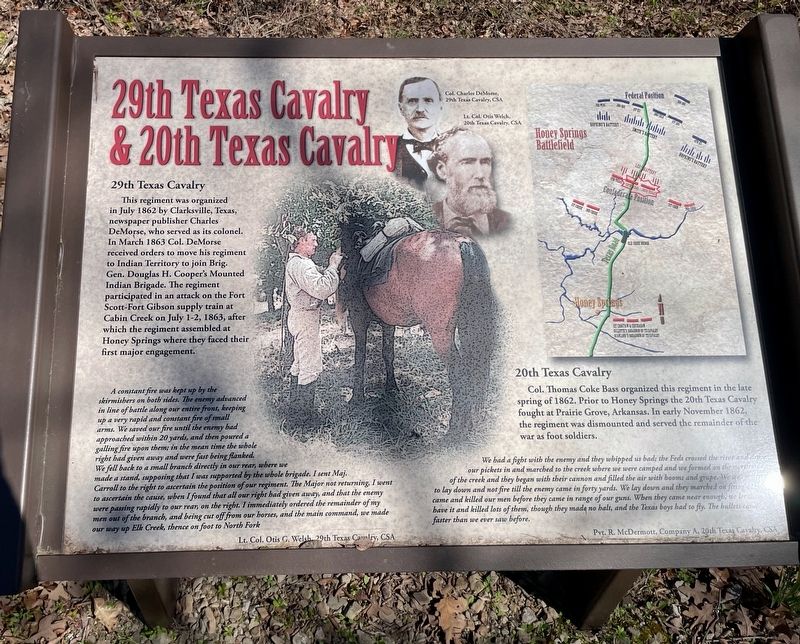
29th Texas Cavalry & 20th Texas Cavalry
Honey Springs Battlefield
— Interpretive Trail Three · Confederate Line —
29th Texas Cavalry
This regiment was organized in July 1862 by Clarksville, Texas, newspaper publisher Charles DeMorse, who served as its colonel. In March 1863 Col. DeMorse received orders to move his regiment to Indian Territory to join Brig. Gen. Douglas H. Cooper's Mounted Indian Brigade. The regiment participated in an attack on the Fort Scott-Fort Gibson supply train at Cabin Creek on July 1-2, 1863, after which the regiment assembled at Honey Springs where they faced their first major engagement.
A constant fire was kept up by the skirmishers on both sides. The enemy advanced in line of battle along our entire front, keeping up a very rapid and constant fire of small arms. We saved our fire until the enemy had approached within 20 yards, and then poured a galling fire upon them; in the mean time the whole right had given away and were fast being flanked. We fell back to a small branch directly in our rear, where we made a stand, supposing that I was supported by the whole brigade. I sent Maj. Carroll to the right to ascertain the position of our regiment. The Major not returning, I went to ascertain the cause, when I found that all our right had given away, and that the enemy were passing rapidly to our rear, on the right. I immediately ordered the remainder of my men out of the branch, and being cut off from our horses, and the main command, we made our way up Elk Creek, thence on foot to North Fork
Lt. Col. Otis G. Welsh, 29th Texas Cavalry, CSA
20th Texas Cavalry
Col. Thomas Coke Bass organized this regiment in the late spring of 1862. Prior to Honey Springs the 20th Texas Cavalry fought at Prairie Grove, Arkansas. In early November 1862, the regiment was dismounted and served the remainder of the war as foot soldiers.
We had a fight with the enemy and they whipped us bad; the Feds crossed the river and drove our pickets in and marched to the creek where we were camped and we formed on the north side of the creek and they began with their cannon and filled the air with booms and grape. We was ordered to lay down and not fire till the enemy came in forty yards. We lay down and they marched on firing as they came and killed our men before they came in range of our guns. When they came near enough, we let them have it and killed lots of them, though they made no halt, and the Texas boys had to fly. The bullets came faster than we ever saw before.
Pvt. R. McDermott, Company A, 20th Texas Cavalry, CSA
[Captions:]
Col. Charles DeMorse,
29th Texas Cavalry, CSA
Lt. Col. Otis Welch,
20th Texas Cavalry, CSA
Erected 2019 by Friends of Honey Springs Battlefield.
Topics and series. This historical marker is listed in this topic list: War, US Civil. In addition, it is included in the Honey Springs Battlefield series list. A significant historical month for this entry is March 1863.
Location. 35° 33.463′ N, 95° 28.318′ W. Marker is near Oktaha, Oklahoma, in Muskogee County. Marker can be reached from Honey Springs Battlefield Road, 1.9 miles north of East 1020 Road, on the right when traveling north. Touch for map. Marker is in this post office area: Oktaha OK 74450, United States of America. Touch for directions.
Other nearby markers. At least 8 other markers are within walking distance of this marker. The Texas Road (within shouting distance of this marker); Breaking the Line, Hand-to-Hand Combat (within shouting distance of this marker); The Confederate Right (within shouting distance of this marker); 1st and 2nd Regiments of Cherokee Mounted Rifles (within shouting distance of this marker); 5th Texas Partisan Rangers and Lee's Light Battery (about 300 feet away, measured in a direct line); The Confederate Center (about 300 feet away); 1st and 2nd Regiments of Creek Mounted Volunteers (about 300 feet away); Primitive Trail to Elk Creek Overlook (about 400 feet away). Touch for a list and map of all markers in Oktaha.
Credits. This page was last revised on March 24, 2024. It was originally submitted on March 24, 2024, by Mark Hilton of Montgomery, Alabama. This page has been viewed 80 times since then. Photos: 1, 2. submitted on March 24, 2024, by Mark Hilton of Montgomery, Alabama.

