
Valliant in McCurtain County, Oklahoma — The American South (West South Central)
Clear Creek Water Mill
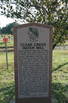
Photographed by Byron Hooks, October 20, 2009
1. Clear Creek Water Mill Marker
Erected 1995 by Oklahoma Historical Society. (Marker Number 196.)
Topics and series. This historical marker is listed in these topic lists: African Americans • Industry & Commerce • Settlements & Settlers. In addition, it is included in the Oklahoma Historical Society series list. A significant historical year for this entry is 1819.
Location. 34° 0.38′ N, 95° 7.165′ W. Marker is in Valliant, Oklahoma, in McCurtain County. It is on U.S. 70 east of Oklahoma Highway N4450, on the left when traveling west. Located at the Valliant Cemetery. Touch for map. Marker is in this post office area: Valliant OK 74764, United States of America. Touch for directions.

Regionally, this marker is in Oklahoma’s Choctaw Nation. It is also in the American South, specifically in the Piney Woods, on the prairies, and on the Southern Plains. Globally, it is in North America, the Western Hemisphere, the Western World, and the Anglosphere. Historically, it finds itself in what was once New Spain, the territory of the Mississippian Culture,
this page online
Other nearby markers. At least 8 other markers are within 8 miles of this marker, measured as the crow flies: Elliott Academy (here, next to this marker); Jesse B. Bowman (approx. 5.9 miles away in Texas); Jane Chandler Gill (approx. 5.9 miles away in Texas); Jonesboro (approx. 5.9 miles away in Texas); Near Here at the Old Jonesboro Crossing Sam Houston (approx. 5.9 miles away in Texas); The Choctaw Nation of Oklahoma (approx. 6.2 miles away); Arnold E. A. Roitsch Archeological Site (approx. 7.1 miles away in Texas); Wheelock Mission (approx. 7½ miles away).

Photographed by Byron Hooks, October 20, 2009
2. Clear Creek Water Mill Marker

Photographed by Jimmy Emerson, May 2024
3. Clear Creek Water Mill & Elliott Academy Markers
Credits. This page was last revised on May 1, 2026. It was originally submitted on November 11, 2009, by Byron Hooks of Sandy Springs, Georgia. This page has been viewed 2,583 times since then and 60 times this year. Photos: 1, 2. submitted on November 11, 2009, by Byron Hooks of Sandy Springs, Georgia. 3. submitted on May 1, 2026, by Jimmy Emerson of Dalton, Georgia. • Kevin W. was the editor who published this page.
