Victoria Park in Kitchener in Waterloo Region, Ontario — Central Canada (North America)
Joseph Schneider Haus

Photographed by Tim Boyd, March 31, 2024
1. Joseph Schneider Haus Marker

this page online
Erected 2000.
Topics and series. This historical marker is listed in these topic lists: Architecture • Industry & Commerce • Settlements & Settlers. In addition, it is included in the Canada, Historic Sites and Monuments Board series list. A significant historical year for this entry is 1816.
Location. 43° 26.694′ N, 80° 29.665′ W. Marker is in Kitchener, Ontario, in Waterloo Region. It is in Victoria Park. It is at the intersection of Queen Street South and Mill Street, on the right when traveling south on Queen Street South. Touch for map. Marker is at or near this postal address: 462 Queen Street S, Kitchener ON N2G 1W7, Canada. Touch for directions.

Regionally, this marker is in the Huron-Perth-Waterloo-Wellington Area and in Southwestern Ontario. It is also in Central Canada. Globally, it is in North America, the Western Hemisphere, the Western World, and the Anglosphere. Historically,

Photographed by Tim Boyd, March 31, 2024
2. Joseph Schneider Haus Marker
Other nearby markers. At least 8 other markers are within walking distance of this marker: The Joseph Schneider House 1820 (here, next to this marker); Centennial of Victoria Park (1896-1996) (about 210 meters away, measured in a direct line); Friedensfest 1871 Denkmal (about 210 meters away); Kitchener Cenotaph (approx. 0.8 kilometers away); St. Mary Our Lady of the Seven Sorrows Roman Catholic Parish (approx. 0.9 kilometers away); Waterloo County (approx. one kilometer away); Waterloo County Registry Office (approx. 1.1 kilometers away); William Lyon Mackenzie King, 1874-1950 (approx. 1.1 kilometers away). Touch for a list and map of all markers in Kitchener.
Also see . . . Dictionary of Canadian Biography - Schneider, Joseph.
Joseph Schneider was an active figure among the Mennonite settlers and, with Benjamin Eby, is often regarded as a founder of Kitchener. He helped open the first local road, which ran from his farmstead to the Dundas road and was known as Schneider’s(Submitted on April 4, 2024, by Tim Boyd of Hamilton, Ontario.)road until the 1870s. In 1808–9 he and four other heads of families hired a teacher to open the first school in the area. He was involved four years later in the building of the first Mennonite meeting-house, headed by Eby; in 1834 Schneider participated in the construction of a new church. Perhaps as early as 1816 he had built a sawmill on what is still known as Schneider’s Creek, and in the 1820s a blacksmith shop and tavern were erected by Phineas Varnum on land leased from Schneider.Photographed by Tim Boyd, March 31, 20243. The Joseph Schneider Haus

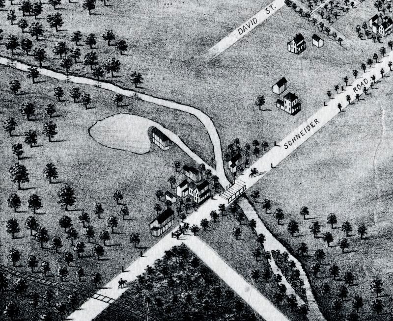
1875
4. Joseph Schneider house and mill, 1875
From a bird’s eye map of Berlin (Kitchener) (Source: University of Waterloo)
Credits. This page was last revised on April 9, 2024. It was originally submitted on April 4, 2024, by Tim Boyd of Hamilton, Ontario. This page has been viewed 244 times since then and 34 times this year. Photos: 1, 2, 3, 4. submitted on April 4, 2024, by Tim Boyd of Hamilton, Ontario. • Andrew Ruppenstein was the editor who published this page.
