Bowmanville in Clarington in Durham Region, Ontario — Central Canada (North America)
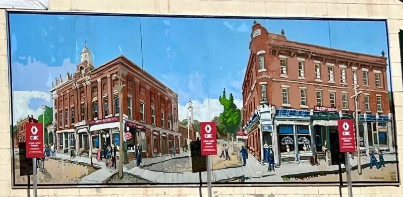
Market Square, Town Hall & Horsey Block, 1880.
Historic Bowmanville

Photographed by Tim Boyd, April 7, 2024
1. Market Square, Town Hall & Horsey Block, 1880. Marker
Bowmanville's second town hall was built in 1885. It was a well used building and included local shops, a jail, library and a second floor council chamber that doubled as a music hall. The building was torn down and replaced by the current town hall in 1903.
Horsey Block was originally called the 'McFeeters Building’ after James McFeeters, Bowmanville's first mayor. The building was purchased and renamed after William Horsey, who served as mayor 1886-87.
This mural was made possible by Loblaws. Friends of Bowmanville.
Erected by Loblaws. Friends of Bowmanville.
Topics. This historical marker is listed in this topic list: Industry & Commerce. A significant historical year for this entry is 1880.
Location. 43° 54.755′ N, 78° 41.325′ W. Marker is in Clarington, Ontario, in Durham Region. It is in Bowmanville. It is at the intersection
this page online

Regionally, this marker is in Greater Toronto, specifically on the Golden Horseshoe, in the York, Durham and Headwaters Area, and in the Toronto Metropolitan Area. It is also in Central Canada. Globally, it is in North America, on the Great Lakes, in the Western Hemisphere, in the Western World, and in the Anglosphere. Historically, it finds itself in what was once a British colony, the Viceroyalty of New France, the Haudenosaunee (Iroquois) Confederacy, and Rupert’s Land.
Other nearby markers. At least 8 other markers are within walking distance of this marker: Lt.-Col. Charles Robert McCullough (within shouting distance of this marker); Bowmanville Cenotaph (within shouting distance of this marker); Bowmanville's First Volunteers, W.W. I (within shouting distance of this marker); Church and Temperance Street, circa 1880 (within shouting distance of this marker); Clarington Municipal Administration Centre (within

Photographed by Tim Boyd, April 7, 2024
2. Market Square, Town Hall & Horsey Block, 1880. Marker
Also see . . . Bowmanville! 150 Years of Celebrating Community.
The area of the downtown on Temperance Street between Church Street and King Street was known as Market Square. Bordered by the Town Hall, the post office and the fire hall people met here to debate, and celebrate. It was here that the residents celebrated historical events such as Queen Victoria's Diamond Jubilee on May 24, 1897 and later the Coronation of her son Edward VII.(Submitted on April 19, 2024, by Tim Boyd of Hamilton, Ontario.)
Photographed by Tim Boyd, April 7, 2018
3. Market Square, Town Hall & Horsey Block, 1880 mural

1917
4. The Horsey Block, 1917
Source: British Library (public domain)
Credits. This page was last revised on April 23, 2024. It was originally submitted on April 19, 2024, by Tim Boyd of Hamilton, Ontario. This page has been viewed 283 times since then and 38 times this year. Photos: 1, 2, 3, 4. submitted on April 19, 2024, by Tim Boyd of Hamilton, Ontario. • Andrew Ruppenstein was the editor who published this page.
