Pennsauken Township in Camden County, New Jersey — The American Northeast (Mid-Atlantic)
Look Listen and Live
Vehicular Safety "Blankout" Signals
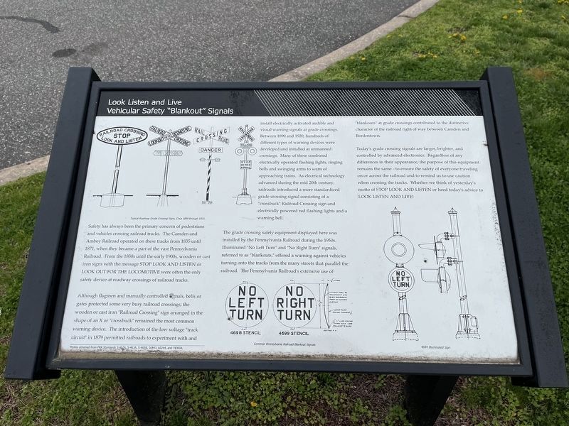
Safety has always been the primary concern of pedestrians and vehicles crossing railroad tracks. The Camden and Amboy Railroad operated on these tracks from 1835 until 1871, when they became a part of the vast Pennsylvania Railroad. From the 1830s until the early 1900s, wooden or cast iron signs with the message Stop Look and Listen or Look Out for the Locomotive were the only safety device at roadway crossings of railroad tracks.
Although flagmen manually controlled signals, bells or gates protected some very busy railroad crossings, the wooden or cast iron "Railroad Crossing" sign arranged in the shape of an X or "crossbuck" remained the most common warning device. The introduction of the low voltage "track circuit" in 1879 permitted railroads to experiment with and install electrically activated audible and visual warning signals at grade crossings. Between 1890 and 1920, hundreds of different types of warning devices were developed and installed at unmanned crossings. Many of these combined electrically operated flashing lights, ringing bells and swinging arms to warn of approaching trains. As electrical technology advanced during the mid 20th century, railroads introduced a more standardized grade crossing signal consisting of a "crossbuck" Railroad Crossing sign and electrically powered red flashing lights and a warning bell.
The grade crossing safety equipment displayed here was installed by the Pennsylvania Railroad during the 1950s. Illuminated "No Left Turn" and "No Right Turn" signals referred to as "blankouts," offered a warning against vehicles turning onto the tracks from the many streets that parallel the railroad. The Pennsylvania Railroad's extensive use of "blankouts" at grade crossings contribute to the distinctive character of the railroad right of way between Camden and Bordentown.
Today's grade crossing signals are larger, brighter, and controlled by advanced electronics. Regardless of any differences in their appearance, the purpose of this equipment remains the same - to ensure the safety of everyone traveling on or across the railroad and to remind us to use caution when crossing the tracks. Whether we think of yesterday's motto of Stop Look and Listen or heed today's advice to Look Listen and Live!
Erected by New Jersey Transit Corporation.
Topics and series. This historical marker is listed in these topic lists: Communications • Railroads & Streetcars • Roads & Vehicles. In addition, it is included in the Pennsylvania Railroad (PRR) series list. A significant historical year for this entry is 1835.
Location. 39° 57.665′ N, 75°
Other nearby markers. At least 8 other markers are within 3 miles of this marker, measured as the crow flies. Advancements in Electrified Railroads (within shouting distance of this marker); South Jersey Vietnam Veterans Memorial (approx. 2.1 miles away); Newton Friends Meetinghouse (approx. 2.2 miles away); Benjamin Franklin Bridge (approx. 2.3 miles away); Lewis L. Coriell, MD, PhD (approx. 2.3 miles away); Bascom S. Waugh, MD (approx. 2.3 miles away); Route 30/130 Cooper River Bridge: A Component of the Cooper River Park (approx. 2.4 miles away); The Cathedral of the Immaculate Conception (approx. 2.4 miles away). Touch for a list and map of all markers in Pennsauken Township.
Credits. This page was last revised on April 19, 2024. It was originally submitted on April 19, 2024, by Devry Becker Jones of Washington, District of Columbia. This page has been viewed 40 times since then. Photos: 1, 2. submitted on April 19, 2024, by Devry Becker Jones of Washington, District of Columbia.

