Rineyville in Hardin County, Kentucky — The American South (East South Central)
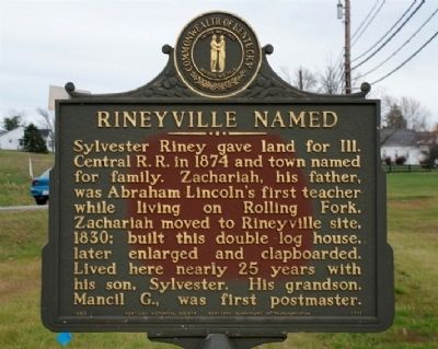
Rineyville Named
Erected 1982 by the Kentucky Historical Society and the Kentucky Department of Transportation. (Marker Number 1711.)
Topics and series. This historical marker is listed in these topic lists: Railroads & Streetcars • Settlements & Settlers. In addition, it is included in the Former U.S. Presidents: #16 Abraham Lincoln, and the Kentucky Historical Society series lists. A significant historical year for this entry is 1874.
Location. Marker has been reported missing. It was located near 37° 44.991′ N, 85° 58.086′ W. Marker was in Rineyville, Kentucky, in Hardin County. Marker was at the intersection of Rineyville Road (State Highway 1600) and Rineyville-Big Springs Road (State Highway 220), on the right when traveling south on Rineyville Road. Touch for map. Marker was in this post office area: Rineyville KY 40162, United States of America. Touch for directions.
Other nearby markers. At least 8 other markers are within 7 miles of this location, measured as the crow flies. Route of Lincolns (approx. 4.3 miles away); The Haycraft Inn (approx. 4.8 miles away); Lincoln Heritage House (approx. 5.6 miles away); Sarah Bush Johnston Lincoln (approx. 5.6 miles away); Helm Cemetery (approx. 5.9 miles away); John Larue Helm, 1802-1867 (approx. 5.9 miles away); John Young Brown (1835-1904) (approx. 6.3 miles away); Van Meter Fort (approx. 6.6 miles away).
Additional commentary.
1. Marker reported missing in 2013.
The state transportation department built a roundabout at the intersection in 2013 to improve traffic flow. The marker has been missing since that time and it was hoped it had been removed for safe keeping because of the construction. The state highway department was contacted but it is still missing. Source about missing marker:
— Submitted October 27, 2019, by Mark Hilton of Montgomery, Alabama.
2. Update to missing marker: Found
Less than 48 hours after this marker, missing for 6 years, was featured in a recent newspaper article, it was returned to Rineyville, dropped alongside KY Highway 220. Source about returned marker:
— Submitted October 29, 2019, by Mark Hilton of Montgomery, Alabama.
Credits. This page was last revised on October 29, 2019. It was originally submitted on November 14, 2009, by Pattie Anne Robinson of Rineyville, Kentucky. This page has been viewed 1,565 times since then and 37 times this year. Photo 1. submitted on November 14, 2009, by Pattie Anne Robinson of Rineyville, Kentucky. • Kevin W. was the editor who published this page.
Editor’s want-list for this marker. Wide area picture of the marker and its surroundings. • Can you help?
