Near Bullock Creek in York County, South Carolina — The American South (South Atlantic)
Lacey's Fort
[Marker Front]
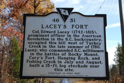
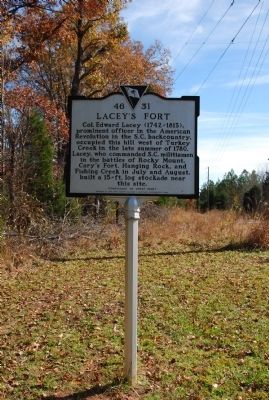
Col. Edward Lacey (1742-1813), prominent officer in the American Revolution in the S.C. backcountry, occupied this hill west of Turkey Creek in the late summer of 1780. Lacey, who commanded S.C. militiamen in the battles of Rocky Mount, Cary's Fort, Hanging Rock, and Fishing Creek in July and August, built a 15-ft. log stockade near this site.
[Marker Reverse]
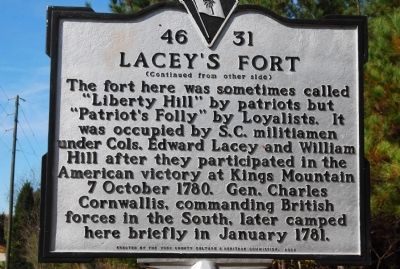
The fort here was sometimes called "Liberty Hill" by patriots but "Patriot's Folly" by Loyalists. It was occupied by S.C. militiamen under Cols. Edward Lacey and William Hill after they participated in the American victory at Kings Mountain 7 October 1780. Gen. Charles Cornwallis, commanding British forces in the South, later camped here briefly in January 1781.
Erected 2001 by York County Historical Commission. (Marker Number 46-31.)
Topics and series. This historical marker is listed in these topic lists: Forts and Castles • War, US Revolutionary. In addition, it is included in the South Carolina, York County Historical Commission series list. A significant historical month for this entry is January 1781.
Location. 34° 51.42′ N, 81° 20.88′ W. Marker is near Bullock Creek, South Carolina, in York County. Marker is at the intersection of West McConnell's Highway (State Highway 322) and Blanton Road, on the left when traveling east on West McConnell's Highway. Touch for map. Marker is in this post office area: Sharon SC 29742, United States of America. Touch for directions.
Other nearby markers. At least 10 other markers are within 8 miles of this marker, measured as the crow flies. Blairsville Schools (approx. 3.4 miles away); Bullock Creek Revolutionary War Monument (approx. 3˝ miles away); Bullock Creek Presbyterian Church (approx. 3.6 miles away); Dickey - Sherer House (approx. 4 miles away); First National Bank of Sharon (approx. 6˝ miles away); Town of Sharon / Sharon (approx. 6.6 miles away); Town of Sharon Stone Marker (approx. 6.6 miles away); McConnells (approx. 6.9 miles away); “Thirteen Original Colonies Bicentennial Covered Wagon Train” (approx. 7 miles away); The Mill Village of Lockhart (approx. 7.9 miles away).
Also see . . .
1. Battle of Rocky Mount. The Battle of Rocky Mount took place on August 1, 1780 as part of the American War of Independence. (Submitted on January 6, 2010, by Brian Scott of Anderson, South Carolina.)
2. The Skirmish at Cary's Fort. Brig. Gen. Thomas Sumter got the approval from Maj. Gen. Horatio Gates for a secondary effort against the British line of communications between Camden and Charleston. (Submitted on January 6, 2010, by Brian Scott of Anderson, South Carolina.)
3. Battle of Hanging Rock. The Battle of Hanging Rock (August 6, 1780) was a battle in the Revolutionary War that occurred between the American Colonies and the British. (Submitted on January 6, 2010, by Brian Scott of Anderson, South Carolina.)
4. The Battle of Hanging Rock. After making plans and arrangements on the 5th, Sumter with 300, mostly mounted, men under Col. William Hill, Maj. Richard Winn, Capt. Edward Lacey, and Capt. John McClure and about 500 North Carolina (mostly Mecklenburg) militia under Col. Robert Irwin, which included some 80 cavalry and mounted militia under Maj. William Richardson Davie, moved to attack the British post at Hanging Rock. (Submitted on January 6, 2010, by Brian Scott of Anderson, South Carolina.)
5. Battle of Fishing Creek. The Battle of Fishing Creek, also called War on Sugar Creek, was an American Revolutionary War battle fought on August 18, 1780, between American and British forces including the 71st Foot. (Submitted on January 6, 2010, by Brian Scott of Anderson, South Carolina.)
6. The Battle of Fishing Creek. On August 16, after the Battle of Camden, Capt. Nathaniel Martin and a couple of dragoons were sent to warn Col. Thomas Sumter of the American loss and to appoint a rendezvous near Charlotte. (Submitted on January 6, 2010, by Brian Scott of Anderson, South Carolina.)
Credits. This page was last revised on April 18, 2021. It was originally submitted on November 15, 2009, by Michael Sean Nix of Spartanburg, South Carolina. This page has been viewed 2,893 times since then and 109 times this year. Photos: 1, 2, 3. submitted on November 15, 2009, by Michael Sean Nix of Spartanburg, South Carolina. • Kevin W. was the editor who published this page.


