Cambridge in Cambridgeshire, England, United Kingdom — Northwestern Europe (the British Isles)
Mill Road Cemetery
Photographed by Ray Gurganus, March 26, 2024
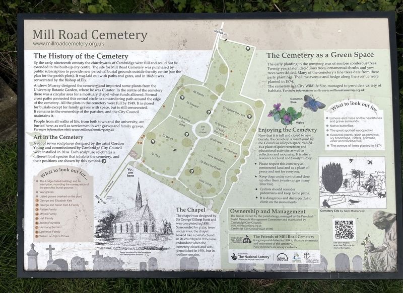
1. Mill Road Cemetery Marker
The History of the Cemetery
By the early nineteenth century the churchyards of Cambridge were full and could not be extended in the built-up city centre. The site for Mill Road Cemetery was purchased by public subscription to provide new parochial burial grounds outside the city centre (see the plan for the parish plots). It was laid out with paths and gates, and in 1848 it was consecrated by the Bishop of Ely.
Andrew Murray designed the cemetery and imported some plants from the University Botanic Garden, where he was Curator. In the centre of the cemetery there was a circular area for a mortuary chapel when funds allowed. Formal cross paths connected this central circle to a meandering path around the edge of the cemetery. All the plots in the cemetery were full by 1949. It is closed for burials except for family graves with space, but is still consecrated. It remains in the ownership of the parishes, and the City Council maintains it.
People from all walks of life, from both town and the university, are buried here, as well as servicemen in war graves and family graves.
Art in the Cemetery
A set of seven
this page online
The Chapel
The chapel was designed by Sir George Gilbert Scott and was completed in 1858. Surrounded by trees and graves, the chapel looked like a parish church in its churchyard. It became redundant when the cemetery closed and was demolished in 1954, but its outline remains.
The Cemetery as a Green Space
The early planting in the cemetery was of sombre coniferous trees. Twenty years later, deciduous trees, ornamental shrubs and yew trees were added. Many of the cemetery's fine trees date from these early plantings. The lime avenue and hedge along the avenue were planted in 1874.
The cemetery is a City Wildlife Site, managed to provide a variety of habitats.
Ownership and Management
The land is owned by the parish clergy, managed by the Parochial Burial Grounds Management Committee and maintained by Cambridge Cry Council.
Topics. This historical marker is listed in this topic

2. Mill Road Cemetery Chapel
Location. 52° 12.125′ N, 0° 8.17′ E. Marker is in Cambridge, England, in Cambridgeshire. It can be reached from Mill Road. The marker is in the southeast corner of Mill Road Cemetery, about 20 meters in from the Mackenzie Road entrance. Touch for map. Marker is in this post office area: Cambridge, England CB1 2AX, United Kingdom. Touch for directions.

Regionally, this marker is in East Anglia. Globally, it is on the Atlantic Ocean, in the North Atlantic Region, in Europe, in Atlantic Europe, on one of the British Isles, in the Western World, and in the Anglosphere. Historically, it finds itself in what was once the Roman Empire.
Other nearby markers. At least 8 other markers are within 24 kilometers of this marker, measured as the crow flies: Cambridge Station Turntable Pivot Cone (approx. 0.8 kilometers away); Stephen Perse (approx. 1.2 kilometers away); Great St. Mary’s Datum (approx. 1.3 kilometers away); Rupert Brooke (approx. 3.9 kilometers away); Great Shelford (approx. 6 kilometers away); Little Shelford Village Design Key (approx. 6.5 kilometers away); Ely Cemetery (approx. 24.3 kilometers away); a different marker also named Ely Cemetery (approx. 24.3 kilometers away). Touch for a list and map of all markers in Cambridge.
Credits. This page was last revised on May 15, 2024. It was originally submitted on May 13, 2024, by Ray Gurganus of Washington, District of Columbia. This page has been viewed 171 times since then and 29 times this year. Photos: 1, 2. submitted on May 13, 2024, by Ray Gurganus of Washington, District of Columbia. • Andrew Ruppenstein was the editor who published this page.
Editor’s want-list for this marker. photo of the marker within its surroundings • Can you help?
